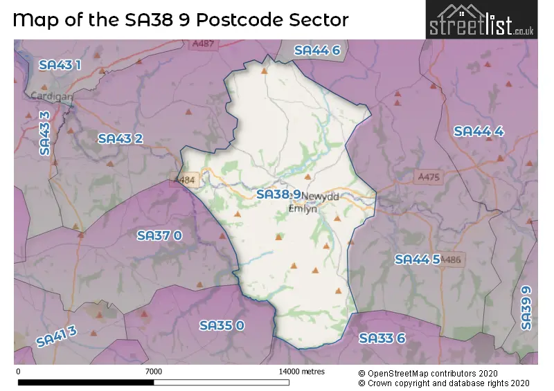
The SA38 9 postcode sector is within the county of Dyfed.
Did you know? According to the 2021 Census, the SA38 9 postcode sector is home to a bustling 4,558 residents!
Given that each sector allows for 400 unique postcode combinations. Letters C, I, K, M, O and V are not allowed in the last two letters of a postcode. With 193 postcodes already in use, this leaves 207 units available.
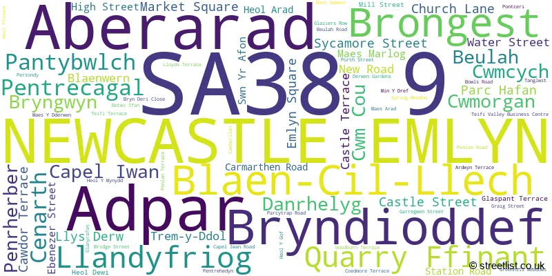
The largest settlement in the SA38 9 postal code is NEWCASTLE EMLYN followed by ADPAR, and CENARTH.
The SA38 9 Postcode shares a border with SA33 6 (CYNWYL ELFED, BRONWYDD, LLANPUMSAINT), SA35 0 (TEGRYN, LLANFYRNACH, CILRHEDYN), SA43 2 (ABERPORTH, LLECHRYD, CILGERRAN), SA37 0 (Blaenffos, BONCATH, NEWCHAPEL), SA44 5 (VELINDRE, RHYDLEWIS, SARON) and SA44 6 (LLANGRANNOG, CROSS INN, SARNAU).
The sector is within the post town of NEWCASTLE EMLYN.
SA38 9 is a postcode sector within the SA38 postcode district which is within the SA Swansea postcode area.
The Royal Mail delivery office for the SA38 9 postal sector is the Llandysul Delivery Office.
The area of the SA38 9 postcode sector is 35.45 square miles which is 91.83 square kilometres or 22,690.78 square acres.

Map of the SA38 9 Postcode Sector
Explore the SA38 9 postcode sector by using our free interactive map.
| S | A | 3 | 8 | - | 9 | X | X |
| S | A | 3 | 8 | Space | 9 | Letter | Letter |
Official List of Streets
Adpar (9 Streets)
Beulah (2 Streets)
NEWCASTLE EMLYN (31 Streets)
Cenarth (4 Streets)
Pentrecagal (1 Streets)
Aberarad (6 Streets)
Cwm Cou (1 Streets)
Unofficial Streets or Alternative Spellings
Beulah
HEOL Y MYNYDDWeather Forecast for SA38 9
Press Button to Show Forecast for Newcastle Emlyn
| Time Period | Icon | Description | Temperature | Rain Probability | Wind |
|---|---|---|---|---|---|
| 00:00 to 03:00 | Heavy rain | 9.0°C (feels like 6.0°C) | 78.00% | SSW 13 mph | |
| 03:00 to 06:00 | Cloudy | 9.0°C (feels like 7.0°C) | 34.00% | SSW 13 mph | |
| 06:00 to 09:00 | Cloudy | 10.0°C (feels like 7.0°C) | 16.00% | SSW 16 mph | |
| 09:00 to 12:00 | Heavy rain | 11.0°C (feels like 7.0°C) | 84.00% | S 20 mph | |
| 12:00 to 15:00 | Heavy rain | 11.0°C (feels like 7.0°C) | 96.00% | S 22 mph | |
| 15:00 to 18:00 | Heavy rain | 11.0°C (feels like 8.0°C) | 82.00% | SSW 18 mph | |
| 18:00 to 21:00 | Light rain | 11.0°C (feels like 8.0°C) | 64.00% | SSW 13 mph | |
| 21:00 to 00:00 | Heavy rain | 10.0°C (feels like 8.0°C) | 87.00% | S 13 mph |
Press Button to Show Forecast for Newcastle Emlyn
| Time Period | Icon | Description | Temperature | Rain Probability | Wind |
|---|---|---|---|---|---|
| 00:00 to 03:00 | Heavy rain | 11.0°C (feels like 7.0°C) | 89.00% | S 18 mph | |
| 03:00 to 06:00 | Heavy rain | 11.0°C (feels like 7.0°C) | 89.00% | SSE 18 mph | |
| 06:00 to 09:00 | Heavy rain | 11.0°C (feels like 7.0°C) | 90.00% | SSE 20 mph | |
| 09:00 to 12:00 | Heavy rain | 11.0°C (feels like 7.0°C) | 92.00% | SSE 20 mph | |
| 12:00 to 15:00 | Heavy rain | 11.0°C (feels like 8.0°C) | 81.00% | S 16 mph | |
| 15:00 to 18:00 | Light rain | 11.0°C (feels like 8.0°C) | 56.00% | S 13 mph | |
| 18:00 to 21:00 | Light rain shower (day) | 11.0°C (feels like 8.0°C) | 38.00% | S 11 mph | |
| 21:00 to 00:00 | Partly cloudy (night) | 9.0°C (feels like 7.0°C) | 8.00% | SSE 9 mph |
Press Button to Show Forecast for Newcastle Emlyn
| Time Period | Icon | Description | Temperature | Rain Probability | Wind |
|---|---|---|---|---|---|
| 00:00 to 03:00 | Clear night | 9.0°C (feels like 6.0°C) | 3.00% | SSE 9 mph | |
| 03:00 to 06:00 | Partly cloudy (night) | 8.0°C (feels like 6.0°C) | 2.00% | SE 9 mph | |
| 06:00 to 09:00 | Partly cloudy (day) | 9.0°C (feels like 6.0°C) | 1.00% | SE 9 mph | |
| 09:00 to 12:00 | Cloudy | 12.0°C (feels like 9.0°C) | 7.00% | SE 11 mph | |
| 12:00 to 15:00 | Cloudy | 13.0°C (feels like 11.0°C) | 9.00% | SSE 9 mph | |
| 15:00 to 18:00 | Cloudy | 13.0°C (feels like 12.0°C) | 8.00% | S 7 mph | |
| 18:00 to 21:00 | Cloudy | 12.0°C (feels like 11.0°C) | 15.00% | WSW 4 mph | |
| 21:00 to 00:00 | Cloudy | 10.0°C (feels like 9.0°C) | 14.00% | W 2 mph |
Press Button to Show Forecast for Newcastle Emlyn
| Time Period | Icon | Description | Temperature | Rain Probability | Wind |
|---|---|---|---|---|---|
| 00:00 to 03:00 | Light rain | 10.0°C (feels like 9.0°C) | 47.00% | N 4 mph | |
| 03:00 to 06:00 | Cloudy | 9.0°C (feels like 8.0°C) | 17.00% | NNW 7 mph | |
| 06:00 to 09:00 | Overcast | 10.0°C (feels like 9.0°C) | 19.00% | NNW 7 mph | |
| 09:00 to 12:00 | Partly cloudy (day) | 12.0°C (feels like 10.0°C) | 13.00% | NNW 9 mph | |
| 12:00 to 15:00 | Overcast | 14.0°C (feels like 12.0°C) | 11.00% | NNW 9 mph | |
| 15:00 to 18:00 | Partly cloudy (day) | 15.0°C (feels like 13.0°C) | 9.00% | NNW 9 mph | |
| 18:00 to 21:00 | Cloudy | 14.0°C (feels like 13.0°C) | 8.00% | NNW 9 mph | |
| 21:00 to 00:00 | Partly cloudy (night) | 11.0°C (feels like 10.0°C) | 5.00% | NNW 7 mph |
House Prices in the SA38 9 Postcode Sector
| Type of Property | 2018 Average | 2018 Sales | 2017 Average | 2017 Sales | 2016 Average | 2016 Sales | 2015 Average | 2015 Sales |
|---|---|---|---|---|---|---|---|---|
| Detached | £232,839 | 41 | £234,753 | 45 | £224,038 | 49 | £191,530 | 42 |
| Semi-Detached | £129,546 | 14 | £140,286 | 14 | £123,194 | 18 | £143,833 | 12 |
| Terraced | £116,500 | 8 | £106,583 | 6 | £101,125 | 8 | £99,000 | 10 |
| Flats | £0 | 0 | £0 | 0 | £166,000 | 1 | £0 | 0 |
Important Postcodes SA38 9 in the Postcode Sector
SA38 9AB is the postcode for Maes Llewelyn Residential Home, Church Lane
SA38 9BA is the postcode for Ysgol Y Ddwylan, New Road
SA38 9JP is the postcode for Cenarth School, Cenarth
SA38 9LN is the postcode for NEWCASTLE EMLYN SPORTS CENTRE, Ysgol Gyfun Emlyn, Ysgol Gyfun Emlyn, LOWER SCHOOL BUILDING, Ysgol Gyfun Emlyn, MAIN SCHOOL, Ysgol Gyfun Emlyn, and Newcastle Emlyn Leisure Centre
SA38 9NS is the postcode for Meddygfa Emlyn, Lloyds Terrace
SA38 9PE is the postcode for Trewen County Primary School, Cwm Cou
SA38 9PT is the postcode for Ysgol Ddwylan, Cwm Cou
| The SA38 9 Sector is within these Local Authorities |
|
|---|---|
| The SA38 9 Sector is within these Counties |
|
| The SA38 9 Sector is within these Water Company Areas |
|