The SG1 6 postcode sector is within the county of Hertfordshire.
Did you know? According to the 2021 Census, the SG1 6 postcode sector is home to a bustling 6,897 residents!
Given that each sector allows for 400 unique postcode combinations. Letters C, I, K, M, O and V are not allowed in the last two letters of a postcode. With 79 postcodes already in use, this leaves 321 units available.
The SG1 6 postal code covers the settlement of STEVENAGE.
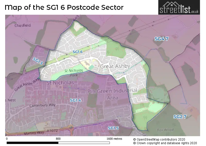
The SG1 6 Postcode shares a border with SG1 3 (STEVENAGE), SG1 4 (STEVENAGE), SG2 7 (STEVENAGE, Walkern, Benington) and SG4 7 (Weston, St. Ippolyts, Little Wymondley).
The sector is within the post town of STEVENAGE.
SG1 6 is a postcode sector within the SG1 postcode district which is within the SG Stevenage postcode area.
The Royal Mail delivery office for the SG1 6 postal sector is the Stevenage Delivery Office.
The area of the SG1 6 postcode sector is 0.46 square miles which is 1.20 square kilometres or 297.36 square acres.

Map of the SG1 6 Postcode Sector
Explore the SG1 6 postcode sector by using our free interactive map.
| S | G | 1 | - | 6 | X | X |
| S | G | 1 | Space | 6 | Letter | Letter |
Official List of Streets
STEVENAGE (45 Streets)
Unofficial Streets or Alternative Spellings
Weather Forecast for SG1 6
Press Button to Show Forecast for Stevenage
| Time Period | Icon | Description | Temperature | Rain Probability | Wind |
|---|---|---|---|---|---|
| 06:00 to 09:00 | Sunny day | 2.0°C (feels like 0.0°C) | 1.00% | NNE 4 mph | |
| 09:00 to 12:00 | Partly cloudy (day) | 7.0°C (feels like 5.0°C) | 1.00% | NE 7 mph | |
| 12:00 to 15:00 | Cloudy | 10.0°C (feels like 9.0°C) | 9.00% | NE 4 mph | |
| 15:00 to 18:00 | Overcast | 10.0°C (feels like 10.0°C) | 12.00% | NE 4 mph | |
| 18:00 to 21:00 | Cloudy | 9.0°C (feels like 7.0°C) | 10.00% | ENE 9 mph | |
| 21:00 to 00:00 | Cloudy | 5.0°C (feels like 3.0°C) | 9.00% | ENE 7 mph |
Press Button to Show Forecast for Stevenage
| Time Period | Icon | Description | Temperature | Rain Probability | Wind |
|---|---|---|---|---|---|
| 00:00 to 03:00 | Cloudy | 4.0°C (feels like 1.0°C) | 11.00% | ENE 7 mph | |
| 03:00 to 06:00 | Cloudy | 3.0°C (feels like 0.0°C) | 14.00% | ENE 7 mph | |
| 06:00 to 09:00 | Cloudy | 4.0°C (feels like 1.0°C) | 21.00% | NE 7 mph | |
| 09:00 to 12:00 | Cloudy | 8.0°C (feels like 6.0°C) | 20.00% | ENE 9 mph | |
| 12:00 to 15:00 | Cloudy | 11.0°C (feels like 9.0°C) | 16.00% | E 9 mph | |
| 15:00 to 18:00 | Cloudy | 12.0°C (feels like 9.0°C) | 18.00% | E 11 mph | |
| 18:00 to 21:00 | Cloudy | 10.0°C (feels like 8.0°C) | 19.00% | ENE 9 mph | |
| 21:00 to 00:00 | Light rain | 8.0°C (feels like 5.0°C) | 52.00% | NE 11 mph |
Press Button to Show Forecast for Stevenage
| Time Period | Icon | Description | Temperature | Rain Probability | Wind |
|---|---|---|---|---|---|
| 00:00 to 03:00 | Heavy rain | 8.0°C (feels like 5.0°C) | 73.00% | NE 11 mph | |
| 03:00 to 06:00 | Heavy rain | 8.0°C (feels like 6.0°C) | 75.00% | ENE 9 mph | |
| 06:00 to 09:00 | Light rain shower (day) | 9.0°C (feels like 7.0°C) | 41.00% | SE 9 mph | |
| 09:00 to 12:00 | Heavy rain | 10.0°C (feels like 8.0°C) | 71.00% | SE 9 mph | |
| 12:00 to 15:00 | Light rain | 11.0°C (feels like 9.0°C) | 53.00% | S 11 mph | |
| 15:00 to 18:00 | Light rain shower (day) | 13.0°C (feels like 10.0°C) | 42.00% | SSW 11 mph | |
| 18:00 to 21:00 | Light rain shower (day) | 11.0°C (feels like 9.0°C) | 35.00% | SW 11 mph | |
| 21:00 to 00:00 | Partly cloudy (night) | 9.0°C (feels like 7.0°C) | 6.00% | WSW 7 mph |
House Prices in the SG1 6 Postcode Sector
| Type of Property | 2018 Average | 2018 Sales | 2017 Average | 2017 Sales | 2016 Average | 2016 Sales | 2015 Average | 2015 Sales |
|---|---|---|---|---|---|---|---|---|
| Detached | £461,687 | 24 | £446,797 | 32 | £451,285 | 34 | £388,661 | 31 |
| Semi-Detached | £334,878 | 45 | £329,903 | 36 | £316,641 | 41 | £292,768 | 34 |
| Terraced | £292,202 | 49 | £294,097 | 67 | £277,770 | 83 | £253,125 | 78 |
| Flats | £161,408 | 19 | £164,839 | 28 | £166,421 | 24 | £149,413 | 23 |
Important Postcodes SG1 6 in the Postcode Sector
SG1 6NH is the postcode for Round Diamond Primary School, Whitehorse Lane
| The SG1 6 Sector is within these Local Authorities |
|
|---|---|
| The SG1 6 Sector is within these Counties |
|
| The SG1 6 Sector is within these Water Company Areas |
|