The SG2 7 postcode sector is within the county of Hertfordshire.
Did you know? According to the 2021 Census, the SG2 7 postcode sector is home to a bustling 7,517 residents!
Given that each sector allows for 400 unique postcode combinations. Letters C, I, K, M, O and V are not allowed in the last two letters of a postcode. With 172 postcodes already in use, this leaves 228 units available.
The largest settlement in the SG2 7 postal code is STEVENAGE followed by Walkern, and Benington.
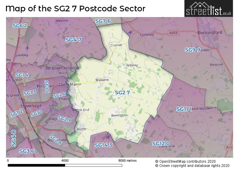
The SG2 7 Postcode shares a border with SG1 4 (STEVENAGE), SG1 6 (STEVENAGE), SG2 0 (STEVENAGE), SG2 8 (STEVENAGE), SG2 9 (STEVENAGE), SG9 9 (BUNTINGFORD, Cottered, Westmill), SG11 1 (Puckeridge, Standon, High Cross), SG12 0 (WARE, Dane End, Thundridge), SG14 3 (HERTFORD, Watton At Stone, Stapleford), SG1 5 (STEVENAGE), SG4 7 (Weston, St. Ippolyts, Little Wymondley), SG7 6 (BALDOCK, Clothall, Wallington) and SG9 0 (Sandon, Furneux Pelham, Rushden).
The sector is within the post town of STEVENAGE.
SG2 7 is a postcode sector within the SG2 postcode district which is within the SG Stevenage postcode area.
The Royal Mail delivery office for the SG2 7 postal sector is the Stevenage Delivery Office.
The area of the SG2 7 postcode sector is 15.31 square miles which is 39.64 square kilometres or 9,796.12 square acres.
Waterways within the SG2 7 postcode sector include the River Beane.

Map of the SG2 7 Postcode Sector
Explore the SG2 7 postcode sector by using our free interactive map.
| S | G | 2 | - | 7 | X | X |
| S | G | 2 | Space | 7 | Letter | Letter |
Official List of Streets
STEVENAGE (30 Streets)
Aston (14 Streets)
Walkern (26 Streets)
Benington (16 Streets)
Cromer (3 Streets)
Ardeley (5 Streets)
Unofficial Streets or Alternative Spellings
STEVENAGE
ALEXANDER GATE BLACKWELL CLOSE BROADHALL WAY BROADWATER CRESCENT FAIRLANDS WAY FERRIER ROAD MANOR HOUSE DRIVE SWEYNS MEAD WHEATLANDSWeather Forecast for SG2 7
Press Button to Show Forecast for Benington Lordship
| Time Period | Icon | Description | Temperature | Rain Probability | Wind |
|---|---|---|---|---|---|
| 12:00 to 15:00 | Overcast | 9.0°C (feels like 6.0°C) | 16.00% | NE 11 mph | |
| 15:00 to 18:00 | Cloudy | 10.0°C (feels like 8.0°C) | 13.00% | NE 11 mph | |
| 18:00 to 21:00 | Cloudy | 9.0°C (feels like 6.0°C) | 18.00% | NE 11 mph | |
| 21:00 to 00:00 | Light rain | 8.0°C (feels like 5.0°C) | 60.00% | NE 11 mph |
Press Button to Show Forecast for Benington Lordship
| Time Period | Icon | Description | Temperature | Rain Probability | Wind |
|---|---|---|---|---|---|
| 00:00 to 03:00 | Heavy rain | 7.0°C (feels like 4.0°C) | 87.00% | NNE 13 mph | |
| 03:00 to 06:00 | Heavy rain | 7.0°C (feels like 4.0°C) | 88.00% | NNE 11 mph | |
| 06:00 to 09:00 | Heavy rain | 8.0°C (feels like 5.0°C) | 87.00% | NE 9 mph | |
| 09:00 to 12:00 | Heavy rain | 8.0°C (feels like 5.0°C) | 82.00% | NW 9 mph | |
| 12:00 to 15:00 | Heavy rain | 8.0°C (feels like 5.0°C) | 77.00% | WNW 11 mph | |
| 15:00 to 18:00 | Light rain | 9.0°C (feels like 6.0°C) | 50.00% | W 11 mph | |
| 18:00 to 21:00 | Light rain | 9.0°C (feels like 8.0°C) | 42.00% | W 7 mph | |
| 21:00 to 00:00 | Partly cloudy (night) | 7.0°C (feels like 5.0°C) | 3.00% | SW 7 mph |
Press Button to Show Forecast for Benington Lordship
| Time Period | Icon | Description | Temperature | Rain Probability | Wind |
|---|---|---|---|---|---|
| 00:00 to 03:00 | Partly cloudy (night) | 6.0°C (feels like 4.0°C) | 3.00% | SW 7 mph | |
| 03:00 to 06:00 | Clear night | 5.0°C (feels like 3.0°C) | 2.00% | SSW 7 mph | |
| 06:00 to 09:00 | Sunny day | 6.0°C (feels like 4.0°C) | 1.00% | S 7 mph | |
| 09:00 to 12:00 | Partly cloudy (day) | 11.0°C (feels like 9.0°C) | 1.00% | S 9 mph | |
| 12:00 to 15:00 | Partly cloudy (day) | 13.0°C (feels like 11.0°C) | 3.00% | S 11 mph | |
| 15:00 to 18:00 | Partly cloudy (day) | 14.0°C (feels like 12.0°C) | 1.00% | S 11 mph | |
| 18:00 to 21:00 | Sunny day | 13.0°C (feels like 11.0°C) | 1.00% | S 9 mph | |
| 21:00 to 00:00 | Clear night | 9.0°C (feels like 7.0°C) | 1.00% | SE 7 mph |
Press Button to Show Forecast for Benington Lordship
| Time Period | Icon | Description | Temperature | Rain Probability | Wind |
|---|---|---|---|---|---|
| 00:00 to 03:00 | Clear night | 8.0°C (feels like 6.0°C) | 1.00% | SE 7 mph | |
| 03:00 to 06:00 | Clear night | 7.0°C (feels like 5.0°C) | 3.00% | SE 7 mph | |
| 06:00 to 09:00 | Partly cloudy (day) | 8.0°C (feels like 6.0°C) | 6.00% | ESE 7 mph | |
| 09:00 to 12:00 | Partly cloudy (day) | 12.0°C (feels like 11.0°C) | 5.00% | SE 9 mph | |
| 12:00 to 15:00 | Cloudy | 15.0°C (feels like 13.0°C) | 10.00% | SE 9 mph | |
| 15:00 to 18:00 | Cloudy | 16.0°C (feels like 14.0°C) | 13.00% | SE 9 mph | |
| 18:00 to 21:00 | Cloudy | 14.0°C (feels like 13.0°C) | 12.00% | ESE 9 mph | |
| 21:00 to 00:00 | Cloudy | 11.0°C (feels like 10.0°C) | 10.00% | ESE 7 mph |
Schools and Places of Education Within the SG2 7 Postcode Sector
Ardeley St Lawrence Church of England Voluntary Aided Primary School
Voluntary aided school
School Lane, Stevenage, Hertfordshire, SG2 7AJ
Head: Mrs Barbara Young
Ofsted Rating: Good
Inspection: 2022-09-22 (583 days ago)
Website: Visit Ardeley St Lawrence Church of England Voluntary Aided Primary School Website
Phone: 01438861284
Number of Pupils: 74
Aston St Mary's Church of England Aided Primary School
Voluntary aided school
School Lane, Stevenage, Hertfordshire, SG2 7HA
Head: Mrs Julie Winwood
Ofsted Rating: Outstanding
Inspection: 2014-12-12 (3424 days ago)
Website: Visit Aston St Mary's Church of England Aided Primary School Website
Phone: 01438880212
Number of Pupils: 127
Benington Church of England Primary School
Voluntary controlled school
Walkern Road, Stevenage, Hertfordshire, SG2 7LP
Head: Mrs Anja Tyler
Ofsted Rating: Good
Inspection: 2018-11-07 (1998 days ago)
Website: Visit Benington Church of England Primary School Website
Phone: 01438869254
Number of Pupils: 91
Walkern Primary School
Community school
High Street, Stevenage, Hertfordshire, SG2 7NS
Head: Mr Jonty Hall
Ofsted Rating: Good
Inspection: 2020-02-26 (1522 days ago)
Website: Visit Walkern Primary School Website
Phone: 01438861285
Number of Pupils: 114
House Prices in the SG2 7 Postcode Sector
| Type of Property | 2018 Average | 2018 Sales | 2017 Average | 2017 Sales | 2016 Average | 2016 Sales | 2015 Average | 2015 Sales |
|---|---|---|---|---|---|---|---|---|
| Detached | £494,184 | 38 | £542,338 | 37 | £511,097 | 59 | £499,103 | 50 |
| Semi-Detached | £385,017 | 26 | £332,512 | 40 | £367,194 | 37 | £334,303 | 33 |
| Terraced | £293,247 | 30 | £267,027 | 37 | £245,607 | 43 | £276,430 | 49 |
| Flats | £194,667 | 3 | £206,250 | 10 | £207,545 | 11 | £142,899 | 5 |
Important Postcodes SG2 7 in the Postcode Sector
SG2 7EL is the postcode for Stevenage Golf Centre, Aston Lane
SG2 7HA is the postcode for Aston St Marys C Of E Primary School, School Lane
SG2 7LP is the postcode for MAIN BLOCK, Benington C of E Primary School, Walkern Road
SG2 7NS is the postcode for Walkern Primary School, High Street
| The SG2 7 Sector is within these Local Authorities |
|
|---|---|
| The SG2 7 Sector is within these Counties |
|
| The SG2 7 Sector is within these Water Company Areas |
|