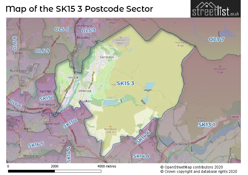
The SK15 3 postcode sector stands on the Derbyshire and Greater Manchester border.
Did you know? According to the 2021 Census, the SK15 3 postcode sector is home to a bustling 9,800 residents!
Given that each sector allows for 400 unique postcode combinations. Letters C, I, K, M, O and V are not allowed in the last two letters of a postcode. With 222 postcodes already in use, this leaves 178 units available.
The largest settlement in the SK15 3 postal code is STALYBRIDGE followed by Carrbrook, and Millbrook.
The SK15 3 Postcode shares a border with OL3 7 (Greenfield), OL5 9 (Mossley), SK15 2 (STALYBRIDGE, Matley), OL6 9 (ASHTON-UNDER-LYNE), SK13 1 (Hadfield, Tintwistle, Padfield), SK14 6 (Mottram, Broadbottom) and SK15 1 (STALYBRIDGE).
The sector is within the post town of STALYBRIDGE.
SK15 3 is a postcode sector within the SK15 postcode district which is within the SK Stockport postcode area.
The Royal Mail delivery office for the SK15 3 postal sector is the Ashton Under Lyne Delivery Office.
The area of the SK15 3 postcode sector is 7.45 square miles which is 19.31 square kilometres or 4,770.60 square acres.
Waterways within the SK15 3 postcode sector include the Huddersfield Narrow Canal.

Map of the SK15 3 Postcode Sector
Explore the SK15 3 postcode sector by using our free interactive map.
| S | K | 1 | 5 | - | 3 | X | X |
| S | K | 1 | 5 | Space | 3 | Letter | Letter |
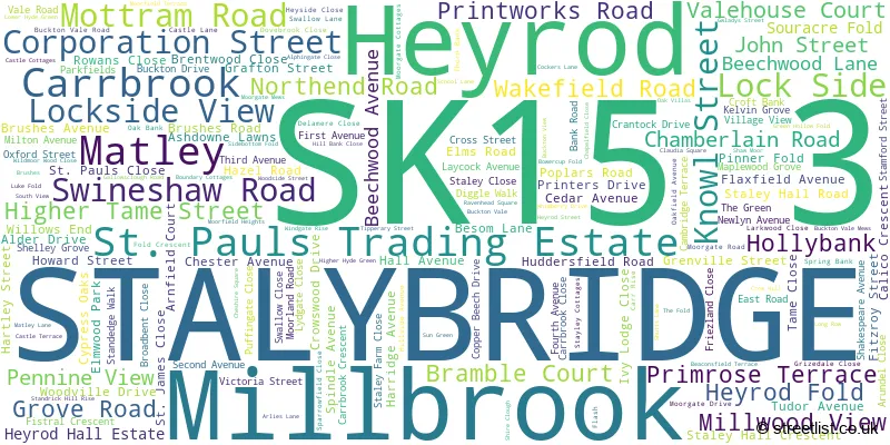
Official List of Streets
STALYBRIDGE (63 Streets)
Carrbrook (60 Streets)
Millbrook (26 Streets)
Heyrod (8 Streets)
Matley (2 Streets)
St. Pauls Trading Estate (1 Streets)
Unofficial Streets or Alternative Spellings
STALYBRIDGE
BARLEYWOOD WALK COPLEY PARK MEWS CORN MILL LANE DEAN STREET FAWNS KEEP LOCKSIDE VIEW LONGRIDGE AVENUE LUKE FOLD SHAWFIELDS STAMFORD STREET TRINITY STREET WALKERWOOD DRIVESt. Pauls Trading Estate
DEMESNE DRIVEMossley
LOWER BEESTOW LUZLEY ROADMatley
MOTTRAM ROADGreenfield
MANCHESTER ROADMottram
HOBSON MOOR ROADWeather Forecast for SK15 3
Press Button to Show Forecast for Millbrook (Greater Manchester)
| Time Period | Icon | Description | Temperature | Rain Probability | Wind |
|---|---|---|---|---|---|
| 03:00 to 06:00 | Light rain | 10.0°C (feels like 8.0°C) | 46.00% | SSW 7 mph | |
| 06:00 to 09:00 | Overcast | 10.0°C (feels like 8.0°C) | 16.00% | SSW 7 mph | |
| 09:00 to 12:00 | Overcast | 11.0°C (feels like 10.0°C) | 12.00% | SSW 9 mph | |
| 12:00 to 15:00 | Cloudy | 13.0°C (feels like 12.0°C) | 11.00% | SSW 9 mph | |
| 15:00 to 18:00 | Cloudy | 14.0°C (feels like 13.0°C) | 13.00% | SSW 9 mph | |
| 18:00 to 21:00 | Cloudy | 14.0°C (feels like 13.0°C) | 11.00% | SW 4 mph | |
| 21:00 to 00:00 | Cloudy | 11.0°C (feels like 11.0°C) | 9.00% | SSE 4 mph |
Press Button to Show Forecast for Millbrook (Greater Manchester)
| Time Period | Icon | Description | Temperature | Rain Probability | Wind |
|---|---|---|---|---|---|
| 00:00 to 03:00 | Partly cloudy (night) | 10.0°C (feels like 9.0°C) | 6.00% | S 4 mph | |
| 03:00 to 06:00 | Cloudy | 10.0°C (feels like 9.0°C) | 9.00% | S 4 mph | |
| 06:00 to 09:00 | Cloudy | 10.0°C (feels like 9.0°C) | 9.00% | S 4 mph | |
| 09:00 to 12:00 | Cloudy | 12.0°C (feels like 12.0°C) | 10.00% | SSE 4 mph | |
| 12:00 to 15:00 | Cloudy | 14.0°C (feels like 13.0°C) | 16.00% | SE 7 mph | |
| 15:00 to 18:00 | Cloudy | 15.0°C (feels like 14.0°C) | 16.00% | WSW 7 mph | |
| 18:00 to 21:00 | Cloudy | 14.0°C (feels like 13.0°C) | 17.00% | SW 7 mph | |
| 21:00 to 00:00 | Partly cloudy (night) | 12.0°C (feels like 11.0°C) | 11.00% | WNW 7 mph |
Schools and Places of Education Within the SK15 3 Postcode Sector
Copley Academy
Academy converter
Huddersfield Road, Stalybridge, Cheshire, SK15 3RR
Head: Mrs Ruth Craven
Ofsted Rating: Requires improvement
Inspection: 2021-12-01 (885 days ago)
Website: Visit Copley Academy Website
Phone: 01613386684
Number of Pupils: 603
Millbrook Primary School
Community school
Bank Road, Stalybridge, Cheshire, SK15 3JX
Head: Miss Elizabeth Turner
Ofsted Rating: Outstanding
Inspection: 2023-12-06 (150 days ago)
Website: Visit Millbrook Primary School Website
Phone: 01457834314
Number of Pupils: 233
St Raphael's Catholic Primary School
Voluntary aided school
Huddersfield Road, Stalybridge, Cheshire, SK15 3JL
Head: Mrs Lynn Lakner
Ofsted Rating: Good
Inspection: 2019-12-11 (1606 days ago)
Website: Visit St Raphael's Catholic Primary School Website
Phone: 01613384095
Number of Pupils: 214
House Prices in the SK15 3 Postcode Sector
| Type of Property | 2018 Average | 2018 Sales | 2017 Average | 2017 Sales | 2016 Average | 2016 Sales | 2015 Average | 2015 Sales |
|---|---|---|---|---|---|---|---|---|
| Detached | £280,426 | 35 | £274,395 | 19 | £237,431 | 32 | £207,893 | 66 |
| Semi-Detached | £166,469 | 55 | £162,619 | 37 | £147,534 | 57 | £139,254 | 77 |
| Terraced | £139,635 | 48 | £123,368 | 45 | £135,848 | 56 | £125,833 | 35 |
| Flats | £91,833 | 18 | £97,357 | 14 | £84,625 | 12 | £82,455 | 11 |
Important Postcodes SK15 3 in the Postcode Sector
SK15 3BJ is the postcode for Millbrook Medical Practice, Hollybank House, Hollybank
SK15 3ET is the postcode for Active Copley, Huddersfield Road
SK15 3JL is the postcode for St. Raphael's Catholic Primary School, Huddersfield Road
SK15 3JX is the postcode for Millbrook Primary School, Bank Road
SK15 3NU is the postcode for Buckton Vale Primary School, Swallow Lane
SK15 3RR is the postcode for Copley Academy, Huddersfield Rd, and Copley Academy, Huddersfield Road
| The SK15 3 Sector is within these Local Authorities |
|
|---|---|
| The SK15 3 Sector is within these Counties |
|
| The SK15 3 Sector is within these Water Company Areas |
|
Tourist Attractions within the SK15 3 Postcode Area
We found 1 visitor attractions within the SK15 postcode area
| Astley Cheetham Art Gallery |
|---|
| Museums & Art Galleries |
| Museum and / or Art Gallery |
| View Astley Cheetham Art Gallery on Google Maps |