The SK15 2 postcode sector is within the county of Greater Manchester.
Did you know? According to the 2021 Census, the SK15 2 postcode sector is home to a bustling 9,271 residents!
Given that each sector allows for 400 unique postcode combinations. Letters C, I, K, M, O and V are not allowed in the last two letters of a postcode. With 217 postcodes already in use, this leaves 183 units available.
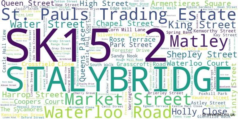
The largest settlements in the SK15 2 postal code are STALYBRIDGE and Matley.
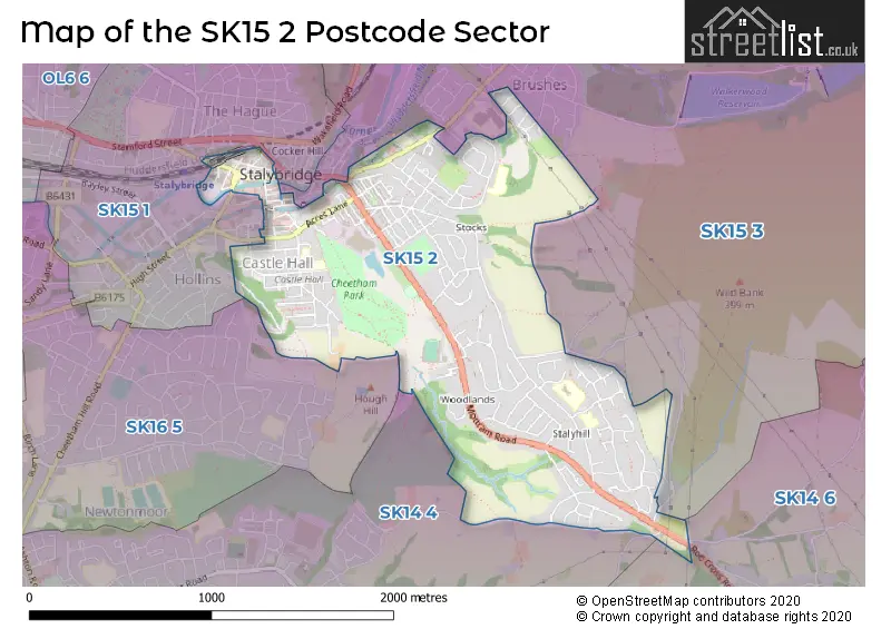
The SK15 2 Postcode shares a border with SK14 4 (HYDE), SK14 6 (Mottram, Broadbottom), SK15 1 (STALYBRIDGE), SK15 3 (STALYBRIDGE, Carrbrook, Millbrook) and SK16 5 (DUKINFIELD).
The sector is within the post town of STALYBRIDGE.
SK15 2 is a postcode sector within the SK15 postcode district which is within the SK Stockport postcode area.
The Royal Mail delivery office for the SK15 2 postal sector is the Ashton Under Lyne Delivery Office.
The area of the SK15 2 postcode sector is 1.20 square miles which is 3.10 square kilometres or 767.10 square acres.
Waterways within the SK15 2 postcode sector include the Huddersfield Narrow Canal.

Map of the SK15 2 Postcode Sector
Explore the SK15 2 postcode sector by using our free interactive map.
| S | K | 1 | 5 | - | 2 | X | X |
| S | K | 1 | 5 | Space | 2 | Letter | Letter |
Official List of Streets
STALYBRIDGE (151 Streets)
St. Pauls Trading Estate (1 Streets)
Matley (2 Streets)
Unofficial Streets or Alternative Spellings
STALYBRIDGE
CAROLINE STREET CASTLE STREET LEECH STREET RASSBOTTOM STREET SHUTTS LANE STAMFORD STREETCarrbrook
HUDDERSFIELD ROAD BACK GROSVENOR STREET BACK MELBOURNE STREET BAKER STREET BENNETT STREET BERRY STREET BLANDFORD STREET BOWERFOLD CROSSLEY STREET DEARDEN STREET FORRESTER DRIVE GIGGLE GAGGLE GORDON STREET GORSE HALL DRIVE HULLY STREET LAWTON STREET PERCY STREET SPRING STREET TONGE GREEN WALMSLEY STREET WINTON STREET WOOD STREETMottram
HOBSON MOOR ROAD OLD ROAD ROE CROSS ROADMatley
GALLOWSCLOUGH ROADWeather Forecast for SK15 2
Press Button to Show Forecast for Stalybridge
| Time Period | Icon | Description | Temperature | Rain Probability | Wind |
|---|---|---|---|---|---|
| 21:00 to 00:00 | Cloudy | 14.0°C (feels like 12.0°C) | 7.00% | ESE 9 mph |
Press Button to Show Forecast for Stalybridge
| Time Period | Icon | Description | Temperature | Rain Probability | Wind |
|---|---|---|---|---|---|
| 00:00 to 03:00 | Cloudy | 13.0°C (feels like 12.0°C) | 4.00% | E 7 mph | |
| 03:00 to 06:00 | Cloudy | 13.0°C (feels like 11.0°C) | 5.00% | ENE 9 mph | |
| 06:00 to 09:00 | Cloudy | 13.0°C (feels like 11.0°C) | 7.00% | NE 9 mph | |
| 09:00 to 12:00 | Cloudy | 15.0°C (feels like 14.0°C) | 9.00% | E 9 mph | |
| 12:00 to 15:00 | Cloudy | 16.0°C (feels like 15.0°C) | 12.00% | E 9 mph | |
| 15:00 to 18:00 | Cloudy | 16.0°C (feels like 15.0°C) | 50.00% | E 9 mph | |
| 18:00 to 21:00 | Light rain | 15.0°C (feels like 15.0°C) | 48.00% | SE 4 mph | |
| 21:00 to 00:00 | Light rain | 14.0°C (feels like 14.0°C) | 50.00% | E 4 mph |
Press Button to Show Forecast for Stalybridge
| Time Period | Icon | Description | Temperature | Rain Probability | Wind |
|---|---|---|---|---|---|
| 00:00 to 03:00 | Cloudy | 13.0°C (feels like 13.0°C) | 37.00% | S 4 mph | |
| 03:00 to 06:00 | Light rain shower (night) | 12.0°C (feels like 12.0°C) | 43.00% | ESE 4 mph | |
| 06:00 to 09:00 | Light rain shower (day) | 13.0°C (feels like 13.0°C) | 41.00% | ESE 2 mph | |
| 09:00 to 12:00 | Cloudy | 16.0°C (feels like 16.0°C) | 11.00% | SSW 2 mph | |
| 12:00 to 15:00 | Cloudy | 18.0°C (feels like 18.0°C) | 13.00% | SW 4 mph | |
| 15:00 to 18:00 | Cloudy | 19.0°C (feels like 18.0°C) | 23.00% | NNW 4 mph | |
| 18:00 to 21:00 | Light rain shower (day) | 18.0°C (feels like 17.0°C) | 41.00% | N 4 mph | |
| 21:00 to 00:00 | Cloudy | 15.0°C (feels like 15.0°C) | 15.00% | N 4 mph |
Press Button to Show Forecast for Stalybridge
| Time Period | Icon | Description | Temperature | Rain Probability | Wind |
|---|---|---|---|---|---|
| 00:00 to 03:00 | Partly cloudy (night) | 14.0°C (feels like 13.0°C) | 6.00% | N 4 mph | |
| 03:00 to 06:00 | Cloudy | 12.0°C (feels like 12.0°C) | 6.00% | NW 4 mph | |
| 06:00 to 09:00 | Partly cloudy (day) | 13.0°C (feels like 12.0°C) | 7.00% | NW 4 mph | |
| 09:00 to 12:00 | Overcast | 14.0°C (feels like 14.0°C) | 14.00% | NW 4 mph | |
| 12:00 to 15:00 | Cloudy | 17.0°C (feels like 16.0°C) | 13.00% | NNW 7 mph | |
| 15:00 to 18:00 | Light rain shower (day) | 18.0°C (feels like 17.0°C) | 39.00% | NNW 7 mph | |
| 18:00 to 21:00 | Light rain shower (day) | 17.0°C (feels like 16.0°C) | 39.00% | NNW 7 mph | |
| 21:00 to 00:00 | Clear night | 15.0°C (feels like 14.0°C) | 9.00% | NE 7 mph |
Press Button to Show Forecast for Stalybridge
| Time Period | Icon | Description | Temperature | Rain Probability | Wind |
|---|---|---|---|---|---|
| 00:00 to 03:00 | Clear night | 13.0°C (feels like 12.0°C) | 5.00% | NE 7 mph | |
| 03:00 to 06:00 | Clear night | 12.0°C (feels like 11.0°C) | 5.00% | NE 4 mph | |
| 06:00 to 09:00 | Partly cloudy (day) | 12.0°C (feels like 12.0°C) | 4.00% | NNE 4 mph | |
| 09:00 to 12:00 | Cloudy | 15.0°C (feels like 14.0°C) | 7.00% | N 7 mph | |
| 12:00 to 15:00 | Partly cloudy (day) | 17.0°C (feels like 16.0°C) | 9.00% | NNE 7 mph | |
| 15:00 to 18:00 | Cloudy | 18.0°C (feels like 16.0°C) | 17.00% | N 9 mph | |
| 18:00 to 21:00 | Sunny day | 17.0°C (feels like 15.0°C) | 12.00% | NNE 9 mph | |
| 21:00 to 00:00 | Clear night | 14.0°C (feels like 13.0°C) | 4.00% | NNE 7 mph |
Schools and Places of Education Within the SK15 2 Postcode Sector
Gorse Hall Primary and Nursery School
Community school
Forester Drive, Stalybridge, Cheshire, SK15 2DP
Head: Miss Alexandra Flood
Ofsted Rating: Good
Inspection: 2023-07-04 (315 days ago)
Website: Visit Gorse Hall Primary and Nursery School Website
Phone: 01613384262
Number of Pupils: 424
St Paul's CofE Primary School, Stalybridge
Academy sponsor led
Huddersfield Road, Stalybridge, Cheshire, SK15 2PT
Head: Mr Simon Wright
Ofsted Rating: Good
Inspection: 2020-01-29 (1567 days ago)
Website: Visit St Paul's CofE Primary School, Stalybridge Website
Phone: 01613382060
Number of Pupils: 224
St Peter's Catholic Primary School
Voluntary aided school
Hough Hill Road, Stalybridge, Cheshire, SK15 2HB
Head: Mrs Katherine Ryan
Ofsted Rating: Good
Inspection: 2023-12-06 (160 days ago)
Website: Visit St Peter's Catholic Primary School Website
Phone: 01613383303
Number of Pupils: 231
Stalyhill Infant School
Community school
Stalyhill Drive, Stalybridge, Cheshire, SK15 2TR
Head: Mrs Lisa Lockett
Ofsted Rating: Good
Inspection: 2022-02-16 (818 days ago)
Website: Visit Stalyhill Infant School Website
Phone: 01457763598
Number of Pupils: 175
Stalyhill Junior School
Community school
Hereford Way, Stalybridge, Cheshire, SK15 2TD
Head: Mrs Lisa Lockett
Ofsted Rating: Good
Inspection: 2019-12-11 (1616 days ago)
Website: Visit Stalyhill Junior School Website
Phone: 01613384290
Number of Pupils: 231
House Prices in the SK15 2 Postcode Sector
| Type of Property | 2018 Average | 2018 Sales | 2017 Average | 2017 Sales | 2016 Average | 2016 Sales | 2015 Average | 2015 Sales |
|---|---|---|---|---|---|---|---|---|
| Detached | £332,931 | 66 | £336,575 | 55 | £316,999 | 65 | £294,684 | 38 |
| Semi-Detached | £201,561 | 33 | £193,615 | 24 | £191,095 | 35 | £177,650 | 20 |
| Terraced | £126,948 | 78 | £119,176 | 82 | £113,724 | 74 | £106,882 | 77 |
| Flats | £127,914 | 11 | £90,577 | 13 | £116,931 | 8 | £90,792 | 6 |
Important Postcodes SK15 2 in the Postcode Sector
SK15 2AE is the postcode for Staveleigh Medical Centre, King Street
SK15 2AU is the postcode for Springleigh and CAMHS Unit, Waterloo Road, Tameside Metropolitan Borough Council, 2 Waterloo Road, and Pennine Care NHS Foundation Trust, Springleigh/Stalybridge Clinic
SK15 2AX is the postcode for 15 WATERLOO ROAD
SK15 2BN is the postcode for Stalybridge Civic Centre, Trinity Street, and Stalybridge Library, 3 Trinity Street
SK15 2DP is the postcode for Nursery, Gorse Hall Primary School, Forester Drive, Main School, Gorse Hall Primary School, Forester Drive, and Gorse Hall Primary School, Forester Drive
SK15 2HB is the postcode for St Peters Catholic Primary School, Hough Hill Road, and St. Peters RC Primary & Nursery School, Hough Hill Road
SK15 2PG is the postcode for Wild Bank Community School, Demesne Drive
SK15 2PT is the postcode for St. Pauls C of E Primary School, Huddersfield Road, and Lockside Medical Centre, 85 Huddersfield Road
SK15 2TD is the postcode for Stalyhill Junior School, Hereford Way
SK15 2TR is the postcode for Stalyhill Infant School, Stalyhill Drive
| The SK15 2 Sector is within these Local Authorities |
|
|---|---|
| The SK15 2 Sector is within these Counties |
|
| The SK15 2 Sector is within these Water Company Areas |
|