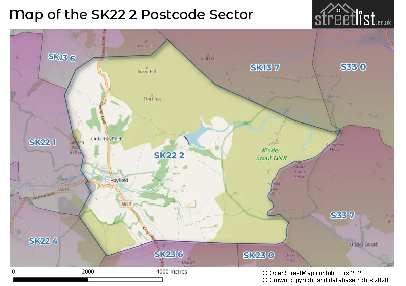
The SK22 2 postcode sector is within the county of Derbyshire.
Did you know? According to the 2021 Census, the SK22 2 postcode sector is home to a bustling 2,280 residents!
Given that each sector allows for 400 unique postcode combinations. Letters C, I, K, M, O and V are not allowed in the last two letters of a postcode. With 78 postcodes already in use, this leaves 322 units available.
The largest settlements in the SK22 2 postal code are Hayfield and Little Hayfield.
The SK22 2 Postcode shares a border with SK23 6 (Chinley), SK13 6 (GLOSSOP, Gamesley), SK13 7 (GLOSSOP), SK22 1 (Birch Vale, Rowarth), SK22 4 (New Mills), SK23 0 (Chapel-en-le-Frith) and S33 7 (Edale).
The sector is within the post town of HIGH PEAK.
SK22 2 is a postcode sector within the SK22 postcode district which is within the SK Stockport postcode area.
The Royal Mail delivery office for the SK22 2 postal sector is the Stockport Central Delivery Office and Hayfield Scale Payment Delivery Office.
The area of the SK22 2 postcode sector is 10.15 square miles which is 26.30 square kilometres or 6,497.99 square acres.
Waterways within the SK22 2 postcode sector include the River Kinder.

Map of the SK22 2 Postcode Sector
Explore the SK22 2 postcode sector by using our free interactive map.
| S | K | 2 | 2 | - | 2 | X | X |
| S | K | 2 | 2 | Space | 2 | Letter | Letter |
Official List of Streets
Hayfield (46 Streets)
Unofficial Streets or Alternative Spellings
Weather Forecast for SK22 2
Press Button to Show Forecast for Kinder Low
| Time Period | Icon | Description | Temperature | Rain Probability | Wind |
|---|---|---|---|---|---|
| 00:00 to 03:00 | Partly cloudy (night) | 13.0°C (feels like 10.0°C) | 4.00% | SE 16 mph | |
| 03:00 to 06:00 | Clear night | 12.0°C (feels like 10.0°C) | 3.00% | SE 11 mph | |
| 06:00 to 09:00 | Partly cloudy (day) | 12.0°C (feels like 9.0°C) | 4.00% | SSE 13 mph | |
| 09:00 to 12:00 | Cloudy | 12.0°C (feels like 9.0°C) | 6.00% | SSE 13 mph | |
| 12:00 to 15:00 | Cloudy | 14.0°C (feels like 10.0°C) | 4.00% | SSE 20 mph | |
| 15:00 to 18:00 | Cloudy | 15.0°C (feels like 11.0°C) | 5.00% | SSE 20 mph | |
| 18:00 to 21:00 | Cloudy | 14.0°C (feels like 10.0°C) | 11.00% | SSE 20 mph | |
| 21:00 to 00:00 | Cloudy | 12.0°C (feels like 8.0°C) | 11.00% | SE 20 mph |
Press Button to Show Forecast for Kinder Low
| Time Period | Icon | Description | Temperature | Rain Probability | Wind |
|---|---|---|---|---|---|
| 00:00 to 03:00 | Cloudy | 10.0°C (feels like 7.0°C) | 16.00% | SE 20 mph | |
| 03:00 to 06:00 | Light rain | 10.0°C (feels like 6.0°C) | 52.00% | ESE 18 mph | |
| 06:00 to 09:00 | Light rain | 10.0°C (feels like 7.0°C) | 56.00% | ESE 16 mph | |
| 09:00 to 12:00 | Heavy rain | 11.0°C (feels like 8.0°C) | 80.00% | ESE 16 mph | |
| 12:00 to 15:00 | Heavy rain | 12.0°C (feels like 9.0°C) | 79.00% | ESE 18 mph | |
| 15:00 to 18:00 | Heavy rain | 12.0°C (feels like 10.0°C) | 77.00% | SE 16 mph | |
| 18:00 to 21:00 | Light rain shower (day) | 11.0°C (feels like 9.0°C) | 47.00% | SE 11 mph | |
| 21:00 to 00:00 | Cloudy | 10.0°C (feels like 7.0°C) | 20.00% | SE 11 mph |
Press Button to Show Forecast for Kinder Low
| Time Period | Icon | Description | Temperature | Rain Probability | Wind |
|---|---|---|---|---|---|
| 00:00 to 03:00 | Cloudy | 8.0°C (feels like 6.0°C) | 11.00% | SE 11 mph | |
| 03:00 to 06:00 | Partly cloudy (night) | 7.0°C (feels like 5.0°C) | 4.00% | ESE 11 mph | |
| 06:00 to 09:00 | Mist | 8.0°C (feels like 6.0°C) | 18.00% | E 11 mph | |
| 09:00 to 12:00 | Cloudy | 11.0°C (feels like 8.0°C) | 12.00% | ESE 11 mph | |
| 12:00 to 15:00 | Light rain shower (day) | 13.0°C (feels like 11.0°C) | 36.00% | ESE 11 mph | |
| 15:00 to 18:00 | Light rain shower (day) | 13.0°C (feels like 11.0°C) | 36.00% | SE 11 mph | |
| 18:00 to 21:00 | Light rain shower (day) | 13.0°C (feels like 11.0°C) | 33.00% | SE 9 mph | |
| 21:00 to 00:00 | Clear night | 9.0°C (feels like 7.0°C) | 3.00% | ESE 9 mph |
Press Button to Show Forecast for Kinder Low
| Time Period | Icon | Description | Temperature | Rain Probability | Wind |
|---|---|---|---|---|---|
| 00:00 to 03:00 | Clear night | 8.0°C (feels like 6.0°C) | 4.00% | E 7 mph | |
| 03:00 to 06:00 | Mist | 7.0°C (feels like 5.0°C) | 13.00% | E 7 mph | |
| 06:00 to 09:00 | Mist | 9.0°C (feels like 7.0°C) | 15.00% | E 7 mph | |
| 09:00 to 12:00 | Sunny day | 12.0°C (feels like 11.0°C) | 5.00% | S 4 mph | |
| 12:00 to 15:00 | Cloudy | 14.0°C (feels like 13.0°C) | 13.00% | SSW 7 mph | |
| 15:00 to 18:00 | Light rain shower (day) | 14.0°C (feels like 13.0°C) | 31.00% | SSW 7 mph | |
| 18:00 to 21:00 | Light rain shower (day) | 13.0°C (feels like 12.0°C) | 29.00% | NW 9 mph | |
| 21:00 to 00:00 | Partly cloudy (night) | 10.0°C (feels like 8.0°C) | 4.00% | SW 9 mph |
Schools and Places of Education Within the SK22 2 Postcode Sector
Hayfield Primary School
Community school
Swallow House Lane, High Peak, Derbyshire, SK22 2HB
Head: Mr Stefan Papadopoulos
Ofsted Rating: Good
Inspection: 2022-01-20 (844 days ago)
Website: Visit Hayfield Primary School Website
Phone: 01663742357
Number of Pupils: 198
House Prices in the SK22 2 Postcode Sector
| Type of Property | 2018 Average | 2018 Sales | 2017 Average | 2017 Sales | 2016 Average | 2016 Sales | 2015 Average | 2015 Sales |
|---|---|---|---|---|---|---|---|---|
| Detached | £376,143 | 14 | £339,182 | 11 | £401,644 | 19 | £380,570 | 14 |
| Semi-Detached | £221,833 | 15 | £233,929 | 7 | £249,611 | 9 | £222,667 | 9 |
| Terraced | £253,265 | 13 | £192,636 | 11 | £197,216 | 16 | £183,153 | 18 |
| Flats | £145,400 | 5 | £158,000 | 5 | £183,333 | 3 | £168,250 | 4 |
Important Postcodes SK22 2 in the Postcode Sector
SK22 2HB is the postcode for Hayfield Primary School, Swallow House Lane, and Main Building, Hayfield Primary School, Swallow House Lane
| The SK22 2 Sector is within these Local Authorities |
|
|---|---|
| The SK22 2 Sector is within these Counties |
|
| The SK22 2 Sector is within these Water Company Areas |
|