The SK5 6 postcode sector is within the county of Greater Manchester.
Did you know? According to the 2021 Census, the SK5 6 postcode sector is home to a bustling 15,097 residents!
Given that each sector allows for 400 unique postcode combinations. Letters C, I, K, M, O and V are not allowed in the last two letters of a postcode. With 277 postcodes already in use, this leaves 123 units available.
The largest settlements in the SK5 6 postal code are STOCKPORT and Reddish.
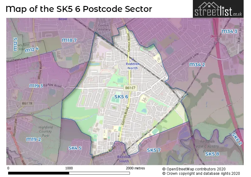
The SK5 6 Postcode shares a border with SK4 5 (STOCKPORT, Heaton Chapel), M18 7 (MANCHESTER, Gorton), M34 2 (Denton), SK5 7 (STOCKPORT) and M19 3 (MANCHESTER, Levenshulme).
The sector is within the post town of STOCKPORT.
SK5 6 is a postcode sector within the SK5 postcode district which is within the SK Stockport postcode area.
The Royal Mail delivery office for the SK5 6 postal sector is the Stockport Central Delivery Office and Stockport 5 Delivery Office and Stockport 1 Delivery Office.
The area of the SK5 6 postcode sector is 1.03 square miles which is 2.67 square kilometres or 659.98 square acres.

Map of the SK5 6 Postcode Sector
Explore the SK5 6 postcode sector by using our free interactive map.
| S | K | 5 | - | 6 | X | X |
| S | K | 5 | Space | 6 | Letter | Letter |
Official List of Streets
STOCKPORT (189 Streets)
Unofficial Streets or Alternative Spellings
STOCKPORT
BROADSTONE ROAD LYNMOUTH AVENUE NELSTROP ROAD NORTH REDDISH ROADDenton
ANSON ROAD ARRAS GROVE ASH ROAD BLUESTONE ROAD GRANADA ROAD LABURNUM ROAD LUXOR GROVE THORNLEY LANE SOUTH WINDMILL LANE ASHBROOK LANE BURGESS BRIDGE CHICKEN LANE CORPORATION YARD DOVER STREET DURHAM STREET FALLOWFIELD LOOP HOLLOW VALE ROAD OADBY PLACE SANDFORD LANE SELBOURNE COURT SKIPTON COURT SORRELL BANK ST ELISABETHS WAY TYRREL ROADMANCHESTER
BROADACRE ROAD CRANBROOK ROAD REDDISH LANEMANCHESTER,
LONGFORD ROAD WESTWeather Forecast for SK5 6
Press Button to Show Forecast for Reddish
| Time Period | Icon | Description | Temperature | Rain Probability | Wind |
|---|---|---|---|---|---|
| 12:00 to 15:00 | Cloudy | 8.0°C (feels like 7.0°C) | 10.00% | E 7 mph | |
| 15:00 to 18:00 | Cloudy | 9.0°C (feels like 8.0°C) | 7.00% | E 7 mph | |
| 18:00 to 21:00 | Cloudy | 8.0°C (feels like 6.0°C) | 7.00% | E 9 mph | |
| 21:00 to 00:00 | Cloudy | 6.0°C (feels like 4.0°C) | 4.00% | ENE 7 mph |
Press Button to Show Forecast for Reddish
| Time Period | Icon | Description | Temperature | Rain Probability | Wind |
|---|---|---|---|---|---|
| 00:00 to 03:00 | Cloudy | 5.0°C (feels like 3.0°C) | 4.00% | ENE 7 mph | |
| 03:00 to 06:00 | Cloudy | 4.0°C (feels like 3.0°C) | 5.00% | NE 4 mph | |
| 06:00 to 09:00 | Partly cloudy (day) | 5.0°C (feels like 3.0°C) | 1.00% | NE 4 mph | |
| 09:00 to 12:00 | Cloudy | 8.0°C (feels like 5.0°C) | 4.00% | ENE 9 mph | |
| 12:00 to 15:00 | Cloudy | 10.0°C (feels like 7.0°C) | 10.00% | ENE 11 mph | |
| 15:00 to 18:00 | Cloudy | 9.0°C (feels like 7.0°C) | 11.00% | ENE 9 mph | |
| 18:00 to 21:00 | Cloudy | 9.0°C (feels like 7.0°C) | 8.00% | ENE 9 mph | |
| 21:00 to 00:00 | Cloudy | 7.0°C (feels like 5.0°C) | 4.00% | NE 7 mph |
Press Button to Show Forecast for Reddish
| Time Period | Icon | Description | Temperature | Rain Probability | Wind |
|---|---|---|---|---|---|
| 00:00 to 03:00 | Cloudy | 6.0°C (feels like 3.0°C) | 4.00% | NE 7 mph | |
| 03:00 to 06:00 | Cloudy | 5.0°C (feels like 3.0°C) | 7.00% | NNE 7 mph | |
| 06:00 to 09:00 | Cloudy | 6.0°C (feels like 3.0°C) | 44.00% | N 9 mph | |
| 09:00 to 12:00 | Light rain | 7.0°C (feels like 5.0°C) | 47.00% | NNW 7 mph | |
| 12:00 to 15:00 | Overcast | 9.0°C (feels like 7.0°C) | 19.00% | NW 9 mph | |
| 15:00 to 18:00 | Cloudy | 10.0°C (feels like 8.0°C) | 13.00% | WNW 11 mph | |
| 18:00 to 21:00 | Sunny day | 10.0°C (feels like 8.0°C) | 4.00% | W 9 mph | |
| 21:00 to 00:00 | Clear night | 7.0°C (feels like 6.0°C) | 2.00% | SW 7 mph |
Press Button to Show Forecast for Reddish
| Time Period | Icon | Description | Temperature | Rain Probability | Wind |
|---|---|---|---|---|---|
| 00:00 to 03:00 | Partly cloudy (night) | 6.0°C (feels like 4.0°C) | 2.00% | S 7 mph | |
| 03:00 to 06:00 | Clear night | 5.0°C (feels like 2.0°C) | 1.00% | SSE 7 mph | |
| 06:00 to 09:00 | Sunny day | 6.0°C (feels like 3.0°C) | 2.00% | SSE 7 mph | |
| 09:00 to 12:00 | Partly cloudy (day) | 10.0°C (feels like 8.0°C) | 2.00% | S 11 mph | |
| 12:00 to 15:00 | Overcast | 13.0°C (feels like 10.0°C) | 11.00% | S 13 mph | |
| 15:00 to 18:00 | Cloudy | 14.0°C (feels like 11.0°C) | 10.00% | S 13 mph | |
| 18:00 to 21:00 | Cloudy | 13.0°C (feels like 11.0°C) | 8.00% | SSE 11 mph | |
| 21:00 to 00:00 | Partly cloudy (night) | 11.0°C (feels like 8.0°C) | 3.00% | SSE 9 mph |
Press Button to Show Forecast for Reddish
| Time Period | Icon | Description | Temperature | Rain Probability | Wind |
|---|---|---|---|---|---|
| 00:00 to 03:00 | Partly cloudy (night) | 9.0°C (feels like 7.0°C) | 3.00% | SE 9 mph | |
| 03:00 to 06:00 | Partly cloudy (night) | 8.0°C (feels like 6.0°C) | 2.00% | SE 9 mph | |
| 06:00 to 09:00 | Sunny day | 9.0°C (feels like 7.0°C) | 2.00% | ESE 9 mph | |
| 09:00 to 12:00 | Partly cloudy (day) | 12.0°C (feels like 10.0°C) | 4.00% | ESE 11 mph | |
| 12:00 to 15:00 | Partly cloudy (day) | 15.0°C (feels like 12.0°C) | 7.00% | SE 13 mph | |
| 15:00 to 18:00 | Cloudy | 16.0°C (feels like 13.0°C) | 12.00% | SE 11 mph | |
| 18:00 to 21:00 | Partly cloudy (day) | 15.0°C (feels like 13.0°C) | 11.00% | ESE 9 mph | |
| 21:00 to 00:00 | Cloudy | 12.0°C (feels like 11.0°C) | 7.00% | ESE 9 mph |
Schools and Places of Education Within the SK5 6 Postcode Sector
Reddish Hall School
Other independent special school
Denstone Road, Stockport, Cheshire, SK5 6UY
Head: Ms Sarah Makin
Ofsted Rating: Good
Inspection: 2023-09-28 (211 days ago)
Website: Visit Reddish Hall School Website
Phone: 01614421197
Number of Pupils: 112
Vale View Primary School
Community school
Mill Lane, Stockport, Cheshire, SK5 6TP
Head: Mr Michael Harding
Ofsted Rating: Requires improvement
Inspection: 2022-02-10 (806 days ago)
Website: Visit Vale View Primary School Website
Phone: 01612210118
Number of Pupils: 445
House Prices in the SK5 6 Postcode Sector
| Type of Property | 2018 Average | 2018 Sales | 2017 Average | 2017 Sales | 2016 Average | 2016 Sales | 2015 Average | 2015 Sales |
|---|---|---|---|---|---|---|---|---|
| Detached | £251,496 | 13 | £236,100 | 15 | £242,944 | 9 | £211,891 | 11 |
| Semi-Detached | £165,027 | 92 | £146,080 | 111 | £145,439 | 86 | £132,381 | 78 |
| Terraced | £132,422 | 120 | £124,293 | 132 | £110,212 | 127 | £108,801 | 124 |
| Flats | £107,556 | 27 | £108,787 | 30 | £103,843 | 95 | £94,354 | 22 |
Important Postcodes SK5 6 in the Postcode Sector
SK5 6BG is the postcode for JUNIOR, St. Joseph's Catholic Primary, Higginson Road, St. Josephs RC Infant School, Higginson Road, St. Joseph's Catholic Primary, Higginson Road, and St Joseph's RC Junior School, Higginson Road
SK5 6BL is the postcode for St. Elisabeths C of E Primary School, St. Elisabeths Way, ANNEX, St. Elisabeths C of E Primary School, St. Elisabeths Way, and ST ELISABETH'S CE PRIMARY SCHOOL, ST ELISABETH'S WAY, NORTH REDDISH
SK5 6ET is the postcode for Park View Group Practice, 2 Longford Road West, and North Reddish Clinic, Longford Road West
SK5 6JW is the postcode for Fir Tree Primary School, Browning Road
SK5 6QG is the postcode for Dane Bank Primary School, Thornley Lane South, and Dane Bank Primary School, Thornley Lane South, Stockport
SK5 6TP is the postcode for Vale View Primary School, Mill Lane
SK5 6XB is the postcode for North Reddish Junior School, Lewis Road
| The SK5 6 Sector is within these Local Authorities |
|
|---|---|
| The SK5 6 Sector is within these Counties |
|
| The SK5 6 Sector is within these Water Company Areas |
|