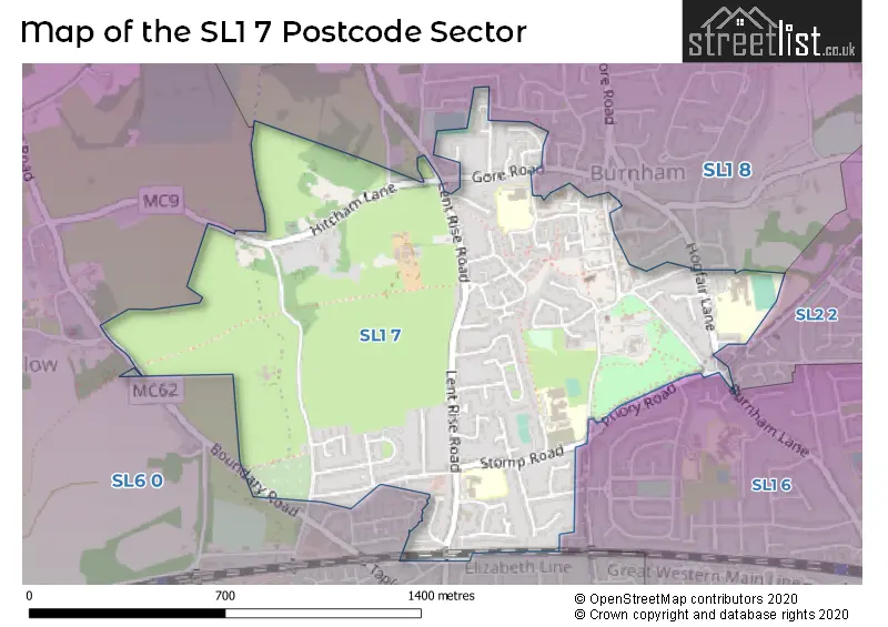
The SL1 7 postcode sector stands on the Berkshire and Buckinghamshire border.
Did you know? According to the 2021 Census, the SL1 7 postcode sector is home to a bustling 5,352 residents!
Given that each sector allows for 400 unique postcode combinations. Letters C, I, K, M, O and V are not allowed in the last two letters of a postcode. With 126 postcodes already in use, this leaves 274 units available.
The SL1 7 postal code covers the settlement of Burnham.
The SL1 7 Postcode shares a border with SL1 6 (SLOUGH, Cippenham, Burnham), SL2 2 (SLOUGH), SL1 8 (Burnham) and SL6 0 (Taplow, Dorney Reach).
The sector is within the post town of SLOUGH.
SL1 7 is a postcode sector within the SL1 postcode district which is within the SL Slough postcode area.
The Royal Mail delivery office for the SL1 7 postal sector is the Slough Delivery Office.
The area of the SL1 7 postcode sector is 0.80 square miles which is 2.07 square kilometres or 511.88 square acres.

Map of the SL1 7 Postcode Sector
Explore the SL1 7 postcode sector by using our free interactive map.
| S | L | 1 | - | 7 | X | X |
| S | L | 1 | Space | 7 | Letter | Letter |
Official List of Streets
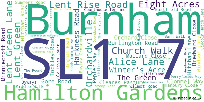
Burnham (55 Streets)
Unofficial Streets or Alternative Spellings
Weather Forecast for SL1 7
Press Button to Show Forecast for Cliveden
| Time Period | Icon | Description | Temperature | Rain Probability | Wind |
|---|---|---|---|---|---|
| 00:00 to 03:00 | Overcast | 7.0°C (feels like 5.0°C) | 18.00% | ENE 9 mph | |
| 03:00 to 06:00 | Light rain | 6.0°C (feels like 4.0°C) | 50.00% | NE 9 mph | |
| 06:00 to 09:00 | Light rain | 6.0°C (feels like 3.0°C) | 50.00% | NE 9 mph | |
| 09:00 to 12:00 | Light rain | 7.0°C (feels like 4.0°C) | 47.00% | NE 11 mph | |
| 12:00 to 15:00 | Overcast | 10.0°C (feels like 7.0°C) | 13.00% | ENE 9 mph | |
| 15:00 to 18:00 | Cloudy | 11.0°C (feels like 9.0°C) | 12.00% | NE 9 mph | |
| 18:00 to 21:00 | Cloudy | 10.0°C (feels like 8.0°C) | 24.00% | NE 11 mph | |
| 21:00 to 00:00 | Light rain | 9.0°C (feels like 6.0°C) | 58.00% | NE 11 mph |
Press Button to Show Forecast for Cliveden
| Time Period | Icon | Description | Temperature | Rain Probability | Wind |
|---|---|---|---|---|---|
| 00:00 to 03:00 | Heavy rain | 8.0°C (feels like 5.0°C) | 85.00% | NNE 11 mph | |
| 03:00 to 06:00 | Heavy rain | 8.0°C (feels like 5.0°C) | 88.00% | NNE 11 mph | |
| 06:00 to 09:00 | Heavy rain | 7.0°C (feels like 5.0°C) | 81.00% | N 9 mph | |
| 09:00 to 12:00 | Heavy rain | 8.0°C (feels like 5.0°C) | 84.00% | NW 9 mph | |
| 12:00 to 15:00 | Light rain | 9.0°C (feels like 6.0°C) | 56.00% | WNW 11 mph | |
| 15:00 to 18:00 | Cloudy | 10.0°C (feels like 8.0°C) | 18.00% | WNW 9 mph | |
| 18:00 to 21:00 | Cloudy | 10.0°C (feels like 9.0°C) | 8.00% | WSW 7 mph | |
| 21:00 to 00:00 | Cloudy | 8.0°C (feels like 7.0°C) | 6.00% | SW 7 mph |
Press Button to Show Forecast for Cliveden
| Time Period | Icon | Description | Temperature | Rain Probability | Wind |
|---|---|---|---|---|---|
| 00:00 to 03:00 | Partly cloudy (night) | 7.0°C (feels like 5.0°C) | 2.00% | SW 4 mph | |
| 03:00 to 06:00 | Clear night | 5.0°C (feels like 4.0°C) | 2.00% | SSW 4 mph | |
| 06:00 to 09:00 | Sunny day | 6.0°C (feels like 5.0°C) | 1.00% | S 4 mph | |
| 09:00 to 12:00 | Partly cloudy (day) | 11.0°C (feels like 10.0°C) | 1.00% | S 9 mph | |
| 12:00 to 15:00 | Cloudy | 14.0°C (feels like 11.0°C) | 5.00% | S 11 mph | |
| 15:00 to 18:00 | Partly cloudy (day) | 15.0°C (feels like 12.0°C) | 4.00% | S 11 mph | |
| 18:00 to 21:00 | Sunny day | 13.0°C (feels like 11.0°C) | 1.00% | S 9 mph | |
| 21:00 to 00:00 | Clear night | 10.0°C (feels like 9.0°C) | 1.00% | SSE 7 mph |
Press Button to Show Forecast for Cliveden
| Time Period | Icon | Description | Temperature | Rain Probability | Wind |
|---|---|---|---|---|---|
| 00:00 to 03:00 | Clear night | 9.0°C (feels like 7.0°C) | 1.00% | SE 7 mph | |
| 03:00 to 06:00 | Clear night | 8.0°C (feels like 7.0°C) | 2.00% | ESE 7 mph | |
| 06:00 to 09:00 | Sunny day | 9.0°C (feels like 8.0°C) | 3.00% | ESE 7 mph | |
| 09:00 to 12:00 | Partly cloudy (day) | 13.0°C (feels like 11.0°C) | 5.00% | ESE 9 mph | |
| 12:00 to 15:00 | Cloudy | 16.0°C (feels like 14.0°C) | 13.00% | SE 9 mph | |
| 15:00 to 18:00 | Cloudy | 16.0°C (feels like 14.0°C) | 10.00% | SE 9 mph | |
| 18:00 to 21:00 | Cloudy | 15.0°C (feels like 14.0°C) | 8.00% | SE 7 mph | |
| 21:00 to 00:00 | Partly cloudy (night) | 12.0°C (feels like 11.0°C) | 5.00% | SE 7 mph |
Schools and Places of Education Within the SL1 7 Postcode Sector
Burnham Grammar School
Academy converter
Hogfair Lane, Slough, Buckinghamshire, SL1 7HG
Head: Dr Andrew Gillespie
Ofsted Rating: Good
Inspection: 2022-12-07 (507 days ago)
Website: Visit Burnham Grammar School Website
Phone: 01628604812
Number of Pupils: 1264
Lent Rise School
Academy converter
Coulson Way, Slough, Buckinghamshire, SL1 7NP
Head: Mrs Jillian Watson
Ofsted Rating: Good
Inspection: 2018-10-18 (2018 days ago)
Website: Visit Lent Rise School Website
Phone: 01628662913
Number of Pupils: 446
St Peter's Church of England Primary School
Voluntary aided school
Minniecroft Road, Burnham, Buckinghamshire, SL1 7DE
Head: Mrs Tanya Morris
Ofsted Rating: Good
Inspection: 2022-02-16 (801 days ago)
Website: Visit St Peter's Church of England Primary School Website
Phone: 01628602295
Number of Pupils: 266
House Prices in the SL1 7 Postcode Sector
| Type of Property | 2018 Average | 2018 Sales | 2017 Average | 2017 Sales | 2016 Average | 2016 Sales | 2015 Average | 2015 Sales |
|---|---|---|---|---|---|---|---|---|
| Detached | £619,500 | 10 | £727,600 | 5 | £533,154 | 13 | £531,200 | 16 |
| Semi-Detached | £448,682 | 22 | £443,286 | 18 | £426,024 | 21 | £392,359 | 26 |
| Terraced | £405,208 | 12 | £367,675 | 20 | £371,398 | 20 | £334,309 | 27 |
| Flats | £221,875 | 4 | £251,813 | 8 | £229,536 | 11 | £204,279 | 21 |
Important Postcodes SL1 7 in the Postcode Sector
SL1 7DE is the postcode for Burnham Health Centre, Minniecroft Road, St Peters Church Of England Combined School, Minniecroft Road, St. Peters C of E Combined School, Minniecroft Road, and Burnham Resource Centre, Minniecroft Road
SL1 7HG is the postcode for Burnham Grammar School, Hogfair Lane
SL1 7HR is the postcode for Buckinghamshire County Council, Burnham Library, Windsor Lane, Burnham Parish Council, Burnham Park Hall, Windsor Lane, and Burnham Park Hall, Windsor Lane
SL1 7LZ is the postcode for DINING & SPORTS BLOCK, Burnham Park E-ACT Academy, Opendale Road, HUMANITIES, Burnham Park E-ACT Academy, Opendale Road, and MAIN BLOCK, Burnham Park E-ACT Academy, Opendale Road
SL1 7NP is the postcode for Lent Rise School, Coulson Way, and Lent Rise School, Coulson Way, Burnham
| The SL1 7 Sector is within these Local Authorities |
|
|---|---|
| The SL1 7 Sector is within these Counties |
|
| The SL1 7 Sector is within these Water Company Areas |
|