The SO19 8 postcode sector is within the county of Hampshire.
Did you know? According to the 2021 Census, the SO19 8 postcode sector is home to a bustling 8,147 residents!
Given that each sector allows for 400 unique postcode combinations. Letters C, I, K, M, O and V are not allowed in the last two letters of a postcode. With 168 postcodes already in use, this leaves 232 units available.
The SO19 8 postal code covers the settlement of SOUTHAMPTON.
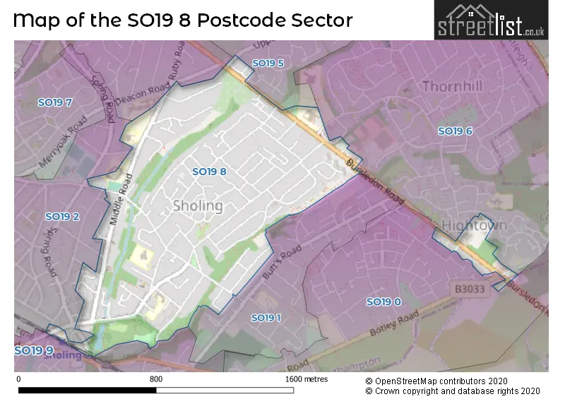
The SO19 8 Postcode shares a border with SO19 0 (SOUTHAMPTON), SO19 1 (SOUTHAMPTON), SO19 6 (SOUTHAMPTON), SO19 2 (SOUTHAMPTON), SO19 5 (SOUTHAMPTON), SO19 7 (SOUTHAMPTON) and SO19 9 (SOUTHAMPTON).
The sector is within the post town of SOUTHAMPTON.
SO19 8 is a postcode sector within the SO19 postcode district which is within the SO Southampton postcode area.
The Royal Mail delivery office for the SO19 8 postal sector is the Bitterne Manor.
The area of the SO19 8 postcode sector is 0.63 square miles which is 1.64 square kilometres or 405.32 square acres.


Map of the SO19 8 Postcode Sector
Explore the SO19 8 postcode sector by using our free interactive map.
| S | O | 1 | 9 | - | 8 | X | X |
| S | O | 1 | 9 | Space | 8 | Letter | Letter |
Official List of Streets
SOUTHAMPTON (68 Streets)
Unofficial Streets or Alternative Spellings
Weather Forecast for SO19 8
Press Button to Show Forecast for Sholing
| Time Period | Icon | Description | Temperature | Rain Probability | Wind |
|---|---|---|---|---|---|
| 18:00 to 21:00 | Heavy rain | 10.0°C (feels like 7.0°C) | 96.00% | NNE 9 mph | |
| 21:00 to 00:00 | Heavy rain | 9.0°C (feels like 6.0°C) | 92.00% | NNE 13 mph |
Press Button to Show Forecast for Sholing
| Time Period | Icon | Description | Temperature | Rain Probability | Wind |
|---|---|---|---|---|---|
| 00:00 to 03:00 | Heavy rain | 8.0°C (feels like 5.0°C) | 92.00% | NNE 13 mph | |
| 03:00 to 06:00 | Heavy rain | 8.0°C (feels like 5.0°C) | 90.00% | N 11 mph | |
| 06:00 to 09:00 | Light rain | 7.0°C (feels like 4.0°C) | 54.00% | NNW 11 mph | |
| 09:00 to 12:00 | Heavy rain | 7.0°C (feels like 3.0°C) | 79.00% | WNW 13 mph | |
| 12:00 to 15:00 | Light rain | 8.0°C (feels like 5.0°C) | 54.00% | W 11 mph | |
| 15:00 to 18:00 | Cloudy | 11.0°C (feels like 9.0°C) | 10.00% | WSW 11 mph | |
| 18:00 to 21:00 | Cloudy | 11.0°C (feels like 9.0°C) | 5.00% | WSW 9 mph | |
| 21:00 to 00:00 | Partly cloudy (night) | 8.0°C (feels like 7.0°C) | 1.00% | SW 7 mph |
Press Button to Show Forecast for Sholing
| Time Period | Icon | Description | Temperature | Rain Probability | Wind |
|---|---|---|---|---|---|
| 00:00 to 03:00 | Clear night | 8.0°C (feels like 6.0°C) | 0.00% | SW 7 mph | |
| 03:00 to 06:00 | Clear night | 7.0°C (feels like 5.0°C) | 1.00% | SSW 7 mph | |
| 06:00 to 09:00 | Sunny day | 9.0°C (feels like 7.0°C) | 0.00% | S 9 mph | |
| 09:00 to 12:00 | Partly cloudy (day) | 12.0°C (feels like 9.0°C) | 2.00% | S 13 mph | |
| 12:00 to 15:00 | Sunny day | 13.0°C (feels like 10.0°C) | 2.00% | S 16 mph | |
| 15:00 to 18:00 | Partly cloudy (day) | 13.0°C (feels like 10.0°C) | 1.00% | S 13 mph | |
| 18:00 to 21:00 | Sunny day | 13.0°C (feels like 11.0°C) | 0.00% | SSE 11 mph | |
| 21:00 to 00:00 | Clear night | 10.0°C (feels like 8.0°C) | 1.00% | SE 9 mph |
Press Button to Show Forecast for Sholing
| Time Period | Icon | Description | Temperature | Rain Probability | Wind |
|---|---|---|---|---|---|
| 00:00 to 03:00 | Clear night | 10.0°C (feels like 8.0°C) | 1.00% | SE 9 mph | |
| 03:00 to 06:00 | Clear night | 9.0°C (feels like 7.0°C) | 1.00% | SE 9 mph | |
| 06:00 to 09:00 | Sunny day | 10.0°C (feels like 8.0°C) | 2.00% | SE 9 mph | |
| 09:00 to 12:00 | Sunny day | 13.0°C (feels like 11.0°C) | 7.00% | SSE 11 mph | |
| 12:00 to 15:00 | Partly cloudy (day) | 14.0°C (feels like 12.0°C) | 10.00% | SSE 11 mph | |
| 15:00 to 18:00 | Partly cloudy (day) | 15.0°C (feels like 13.0°C) | 10.00% | SSE 11 mph | |
| 18:00 to 21:00 | Sunny day | 14.0°C (feels like 12.0°C) | 8.00% | SE 7 mph | |
| 21:00 to 00:00 | Cloudy | 11.0°C (feels like 10.0°C) | 10.00% | ESE 7 mph |
Press Button to Show Forecast for Sholing
| Time Period | Icon | Description | Temperature | Rain Probability | Wind |
|---|---|---|---|---|---|
| 00:00 to 03:00 | Cloudy | 10.0°C (feels like 9.0°C) | 9.00% | ESE 4 mph | |
| 03:00 to 06:00 | Mist | 9.0°C (feels like 9.0°C) | 19.00% | E 4 mph | |
| 06:00 to 09:00 | Cloudy | 10.0°C (feels like 9.0°C) | 11.00% | ENE 4 mph | |
| 09:00 to 12:00 | Cloudy | 14.0°C (feels like 13.0°C) | 17.00% | ESE 4 mph | |
| 12:00 to 15:00 | Cloudy | 16.0°C (feels like 15.0°C) | 13.00% | SE 7 mph | |
| 15:00 to 18:00 | Cloudy | 16.0°C (feels like 15.0°C) | 16.00% | SSE 7 mph | |
| 18:00 to 21:00 | Cloudy | 15.0°C (feels like 14.0°C) | 18.00% | SSW 4 mph | |
| 21:00 to 00:00 | Light rain shower (night) | 13.0°C (feels like 12.0°C) | 40.00% | WNW 4 mph |
Schools and Places of Education Within the SO19 8 Postcode Sector
Oasis Academy Sholing
Academy sponsor led
Middle Road, Southampton, , SO19 8PH
Head: Mr Martin Brown
Ofsted Rating: Requires improvement
Inspection: 2022-10-12 (563 days ago)
Website: Visit Oasis Academy Sholing Website
Phone: 02380448861
Number of Pupils: 1040
Sholing Junior School
Academy converter
Middle Road, Southampton, Hampshire, SO19 8PT
Head: Mr Matthew Abbott
Ofsted Rating: Good
Inspection: 2022-06-29 (668 days ago)
Website: Visit Sholing Junior School Website
Phone: 02380447448
Number of Pupils: 351
House Prices in the SO19 8 Postcode Sector
| Type of Property | 2018 Average | 2018 Sales | 2017 Average | 2017 Sales | 2016 Average | 2016 Sales | 2015 Average | 2015 Sales |
|---|---|---|---|---|---|---|---|---|
| Detached | £293,222 | 29 | £268,897 | 33 | £247,567 | 26 | £235,259 | 40 |
| Semi-Detached | £228,630 | 68 | £230,233 | 65 | £215,765 | 62 | £194,338 | 54 |
| Terraced | £214,642 | 30 | £212,957 | 35 | £184,611 | 28 | £176,279 | 36 |
| Flats | £134,135 | 26 | £120,503 | 38 | £118,051 | 32 | £102,318 | 48 |
Important Postcodes SO19 8 in the Postcode Sector
SO19 8ES is the postcode for St. Monica Primary School, St. Monica Road, ENDEAVOUR SITE, St. Monica Primary School, St. Monica Road, and Endeavour Building, St. Monica Primary School, St. Monica Road
SO19 8EZ is the postcode for INSPIRE SITE, St. Monica Primary School, Bay Road, Inspire Early Years Building, St. Monica Primary School, Bay Road, Inspire Building, St. Monica Primary School, Bay Road, and St. Monica Primary School, Bay Road
SO19 8PH is the postcode for SPORTS BLOCK, Oasis Academy Sholing, Middle Road, ART BLOCK, Oasis Academy Sholing, Middle Road, SCIENCE BLOCK, Oasis Academy Sholing, Middle Road, Oasis Academy Sholing, Middle Road, HUMANITIES BLOCK, Oasis Academy Sholing, Middle Road, and MAIN SCHOOL, Oasis Academy Sholing, Middle Road
SO19 8PT is the postcode for SHOLING JUNIOR SCHOOL, MIDDLE ROAD, SOUTHAMPTON, and Sholing Junior School, Middle Road
| The SO19 8 Sector is within these Local Authorities |
|
|---|---|
| The SO19 8 Sector is within these Counties |
|
| The SO19 8 Sector is within these Water Company Areas |
|