The SO52 9 postcode sector is within the county of Hampshire.
Did you know? According to the 2021 Census, the SO52 9 postcode sector is home to a bustling 7,205 residents!
Given that each sector allows for 400 unique postcode combinations. Letters C, I, K, M, O and V are not allowed in the last two letters of a postcode. With 173 postcodes already in use, this leaves 227 units available.
The SO52 9 postal code covers the settlement of North Baddesley.
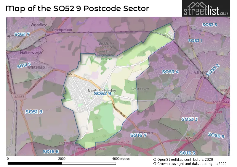
The SO52 9 Postcode shares a border with SO53 1 (Chandler's Ford), SO53 4 (Chandler's Ford), SO16 7 (SOUTHAMPTON, Chilworth), SO16 8 (SOUTHAMPTON, Rownhams, Nursling), SO51 9 (Ampfield, ROMSEY, Crampmoor) and SO53 5 (Chandler's Ford).
The sector is within the post town of SOUTHAMPTON.
SO52 9 is a postcode sector within the SO51 postcode district which is within the SO Southampton postcode area.
The Royal Mail delivery office for the SO52 9 postal sector is the Romsey Delivery Office.
The area of the SO52 9 postcode sector is 3.32 square miles which is 8.59 square kilometres or 2,122.37 square acres.
The SO52 9 postcode sector is crossed by the M27 motorway.
Waterways within the SO52 9 postcode sector include the Tanners Brook.

Map of the SO52 9 Postcode Sector
Explore the SO52 9 postcode sector by using our free interactive map.
| S | O | 5 | 2 | - | 9 | X | X |
| S | O | 5 | 2 | Space | 9 | Letter | Letter |
Official List of Streets
North Baddesley (101 Streets)
Unofficial Streets or Alternative Spellings
Chilworth
CHILWORTH OLD VILLAGE CHILWORTH ROADChandler's Ford
BADDESLEY ROAD CASTLE LANE BEECHWOOD CLOSE CAMELIA CLOSE DIRTY DRIVE GAINSBOROUGH COURT KNIGHTS MEADOWS LIINDEN WALK MANOR FARM OFFICES NUTBURN MEADOWS ROSSLYN MEWS ST JAMES PARK ST. GEORGES COURTAmpfield
POUND LANEROMSEY
PACKRIDGE LANEWeather Forecast for SO52 9
Press Button to Show Forecast for Sir Harold Hillier Gardens And Arboretum Ampfield
| Time Period | Icon | Description | Temperature | Rain Probability | Wind |
|---|---|---|---|---|---|
| 06:00 to 09:00 | Cloudy | 6.0°C (feels like 3.0°C) | 8.00% | ENE 7 mph | |
| 09:00 to 12:00 | Cloudy | 8.0°C (feels like 5.0°C) | 9.00% | ENE 9 mph | |
| 12:00 to 15:00 | Overcast | 10.0°C (feels like 8.0°C) | 19.00% | E 7 mph | |
| 15:00 to 18:00 | Overcast | 10.0°C (feels like 9.0°C) | 19.00% | E 7 mph | |
| 18:00 to 21:00 | Cloudy | 10.0°C (feels like 9.0°C) | 13.00% | ENE 7 mph | |
| 21:00 to 00:00 | Cloudy | 6.0°C (feels like 4.0°C) | 11.00% | E 7 mph |
Press Button to Show Forecast for Sir Harold Hillier Gardens And Arboretum Ampfield
| Time Period | Icon | Description | Temperature | Rain Probability | Wind |
|---|---|---|---|---|---|
| 00:00 to 03:00 | Cloudy | 5.0°C (feels like 3.0°C) | 15.00% | ENE 7 mph | |
| 03:00 to 06:00 | Light rain | 6.0°C (feels like 3.0°C) | 51.00% | ENE 7 mph | |
| 06:00 to 09:00 | Light rain | 6.0°C (feels like 3.0°C) | 47.00% | ENE 9 mph | |
| 09:00 to 12:00 | Cloudy | 9.0°C (feels like 6.0°C) | 16.00% | ENE 11 mph | |
| 12:00 to 15:00 | Overcast | 12.0°C (feels like 9.0°C) | 18.00% | E 11 mph | |
| 15:00 to 18:00 | Light rain | 12.0°C (feels like 9.0°C) | 52.00% | ENE 11 mph | |
| 18:00 to 21:00 | Light rain | 10.0°C (feels like 8.0°C) | 54.00% | ENE 11 mph | |
| 21:00 to 00:00 | Heavy rain | 9.0°C (feels like 6.0°C) | 74.00% | ENE 11 mph |
Press Button to Show Forecast for Sir Harold Hillier Gardens And Arboretum Ampfield
| Time Period | Icon | Description | Temperature | Rain Probability | Wind |
|---|---|---|---|---|---|
| 00:00 to 03:00 | Heavy rain | 8.0°C (feels like 5.0°C) | 76.00% | ENE 11 mph | |
| 03:00 to 06:00 | Heavy rain shower (night) | 8.0°C (feels like 5.0°C) | 61.00% | ENE 9 mph | |
| 06:00 to 09:00 | Light rain | 8.0°C (feels like 6.0°C) | 52.00% | E 9 mph | |
| 09:00 to 12:00 | Light rain shower (day) | 11.0°C (feels like 9.0°C) | 38.00% | NE 9 mph | |
| 12:00 to 15:00 | Light rain shower (day) | 12.0°C (feels like 10.0°C) | 38.00% | SW 11 mph | |
| 15:00 to 18:00 | Light rain shower (day) | 11.0°C (feels like 9.0°C) | 41.00% | SW 11 mph | |
| 18:00 to 21:00 | Light rain shower (day) | 11.0°C (feels like 9.0°C) | 33.00% | W 9 mph | |
| 21:00 to 00:00 | Partly cloudy (night) | 7.0°C (feels like 6.0°C) | 4.00% | WSW 7 mph |
Schools and Places of Education Within the SO52 9 Postcode Sector
North Baddesley Infant School
Community school
Botley Road, Southampton, Hampshire, SO52 9EE
Head: Mrs Carla Lashmar
Ofsted Rating: Good
Inspection: 2023-03-08 (415 days ago)
Website: Visit North Baddesley Infant School Website
Phone: 02380412412
Number of Pupils: 299
North Baddesley Junior School
Community school
Fleming Avenue, Southampton, Hampshire, SO52 9EP
Head: Miss Lucy Wootten
Ofsted Rating: Good
Inspection: 2023-02-08 (443 days ago)
Website: Visit North Baddesley Junior School Website
Phone: 02380411100
Number of Pupils: 316
House Prices in the SO52 9 Postcode Sector
| Type of Property | 2018 Average | 2018 Sales | 2017 Average | 2017 Sales | 2016 Average | 2016 Sales | 2015 Average | 2015 Sales |
|---|---|---|---|---|---|---|---|---|
| Detached | £440,277 | 47 | £430,327 | 44 | £371,168 | 35 | £385,023 | 79 |
| Semi-Detached | £312,974 | 39 | £287,131 | 34 | £274,110 | 36 | £269,866 | 56 |
| Terraced | £252,109 | 35 | £257,187 | 30 | £251,593 | 27 | £216,320 | 37 |
| Flats | £167,000 | 3 | £166,250 | 8 | £154,000 | 7 | £140,963 | 8 |
Important Postcodes SO52 9 in the Postcode Sector
SO52 9EE is the postcode for North Baddesley Infant School, 140 Botley Road
SO52 9EP is the postcode for North Baddesley Junior School, Fleming Avenue, and North Baddesley Health Centre, Fleming Avenue
| The SO52 9 Sector is within these Local Authorities |
|
|---|---|
| The SO52 9 Sector is within these Counties |
|
| The SO52 9 Sector is within these Water Company Areas |
|