The SP10 3 postcode sector is within the county of Hampshire.
Did you know? According to the 2021 Census, the SP10 3 postcode sector is home to a bustling 13,138 residents!
Given that each sector allows for 400 unique postcode combinations. Letters C, I, K, M, O and V are not allowed in the last two letters of a postcode. With 315 postcodes already in use, this leaves 85 units available.
The SP10 3 postal code covers the settlement of ANDOVER.
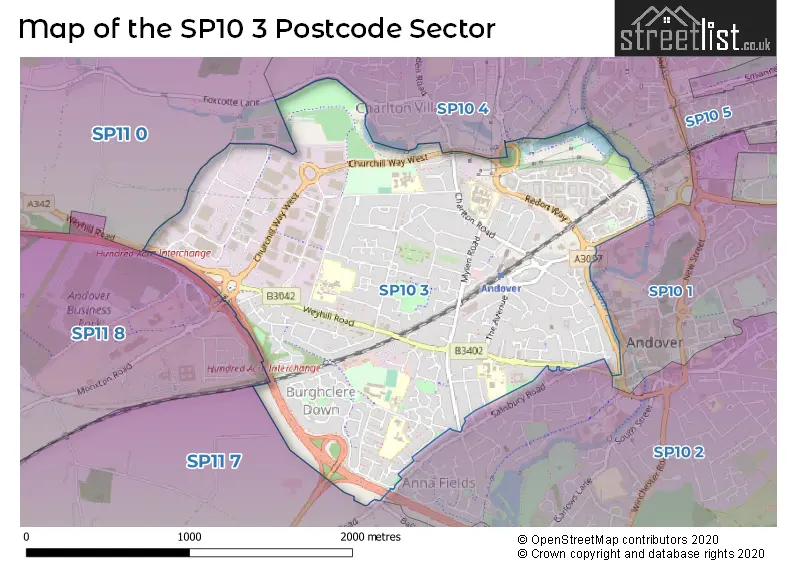
The SP10 3 Postcode shares a border with SP10 2 (ANDOVER), SP10 4 (ANDOVER, Charlton), SP11 8 (Weyhill, Thruxton, Amport), SP10 1 (ANDOVER), SP11 0 (Weyhill, Hurstbourne Tarrant, Vernham Dean) and SP11 7 (Abbotts Ann, Goodworth Clatford, Anna Valley).
The sector is within the post town of ANDOVER.
SP10 3 is a postcode sector within the SP10 postcode district which is within the SP Salisbury postcode area.
The Royal Mail delivery office for the SP10 3 postal sector is the Andover Delivery Office.
The area of the SP10 3 postcode sector is 1.72 square miles which is 4.46 square kilometres or 1,102.85 square acres.
The SP10 3 postcode sector is crossed by the A303 Major A road.
Waterways within the SP10 3 postcode sector include the River Anton.

Map of the SP10 3 Postcode Sector
Explore the SP10 3 postcode sector by using our free interactive map.
| S | P | 1 | 0 | - | 3 | X | X |
| S | P | 1 | 0 | Space | 3 | Letter | Letter |
Official List of Streets
ANDOVER (181 Streets)
Unofficial Streets or Alternative Spellings
ANDOVER
EDISON GATE NORTHERN AVENUE PARNELL COURT WEST STREET WESTERN AVENUE WESTERN ROAD ANTON LAKES CYCLE PATH ANTON LAKES PARKING ANTON LAKES PATH BISHOPS COURT CHARLTON LAKES CYCLE PATH FILTCHES GROVE FOLLY ROUNDABOUT FOLLY ROUNDABOUT CYCLE PATH GOCH WAY GOGH WAY HARDY COURT HENRY GAMMAN DRIVE HILLSIDE COURT HUNDRED ACRE INTERCHANGE KEEBLE PLACE KENYONS YARD KILWORTH COURT MACADAM WAY PORTERS CLOSE POYNTERS CLOSE REDON WAY SAXON FIELDS CYCLE PATH SMEATON ROAD SOPWITH PARK THE CROSSWAYS THE LAURELS WARNER COURT WESTERN AVENUE CYCLE PATH (WEST) WOODCUTTERS COURT WYKEHAM COURTAbbotts Ann
SALISBURY ROADRed Post Bridge
MONXTON ROADPenton Corner
WEYHILL ROADWeather Forecast for SP10 3
Press Button to Show Forecast for Andover
| Time Period | Icon | Description | Temperature | Rain Probability | Wind |
|---|---|---|---|---|---|
| 00:00 to 03:00 | Cloudy | 7.0°C (feels like 4.0°C) | 5.00% | NE 7 mph | |
| 03:00 to 06:00 | Cloudy | 6.0°C (feels like 3.0°C) | 7.00% | ENE 7 mph | |
| 06:00 to 09:00 | Cloudy | 5.0°C (feels like 2.0°C) | 7.00% | ENE 7 mph | |
| 09:00 to 12:00 | Cloudy | 7.0°C (feels like 5.0°C) | 8.00% | ENE 9 mph | |
| 12:00 to 15:00 | Cloudy | 10.0°C (feels like 8.0°C) | 17.00% | E 9 mph | |
| 15:00 to 18:00 | Cloudy | 10.0°C (feels like 9.0°C) | 16.00% | ENE 7 mph | |
| 18:00 to 21:00 | Overcast | 9.0°C (feels like 8.0°C) | 18.00% | ENE 7 mph | |
| 21:00 to 00:00 | Cloudy | 7.0°C (feels like 4.0°C) | 11.00% | ENE 7 mph |
Press Button to Show Forecast for Andover
| Time Period | Icon | Description | Temperature | Rain Probability | Wind |
|---|---|---|---|---|---|
| 00:00 to 03:00 | Cloudy | 5.0°C (feels like 3.0°C) | 17.00% | ENE 7 mph | |
| 03:00 to 06:00 | Light rain | 5.0°C (feels like 2.0°C) | 50.00% | ENE 7 mph | |
| 06:00 to 09:00 | Overcast | 5.0°C (feels like 3.0°C) | 23.00% | NE 9 mph | |
| 09:00 to 12:00 | Cloudy | 8.0°C (feels like 5.0°C) | 18.00% | ENE 11 mph | |
| 12:00 to 15:00 | Overcast | 11.0°C (feels like 9.0°C) | 20.00% | ENE 11 mph | |
| 15:00 to 18:00 | Light rain | 11.0°C (feels like 9.0°C) | 51.00% | ENE 11 mph | |
| 18:00 to 21:00 | Light rain | 10.0°C (feels like 8.0°C) | 52.00% | ENE 11 mph | |
| 21:00 to 00:00 | Light rain | 9.0°C (feels like 6.0°C) | 54.00% | NE 11 mph |
Press Button to Show Forecast for Andover
| Time Period | Icon | Description | Temperature | Rain Probability | Wind |
|---|---|---|---|---|---|
| 00:00 to 03:00 | Heavy rain | 8.0°C (feels like 5.0°C) | 75.00% | NE 13 mph | |
| 03:00 to 06:00 | Heavy rain | 8.0°C (feels like 5.0°C) | 76.00% | NE 11 mph | |
| 06:00 to 09:00 | Heavy rain | 8.0°C (feels like 6.0°C) | 72.00% | ENE 9 mph | |
| 09:00 to 12:00 | Light rain shower (day) | 10.0°C (feels like 8.0°C) | 37.00% | NE 9 mph | |
| 12:00 to 15:00 | Light rain shower (day) | 12.0°C (feels like 9.0°C) | 40.00% | SW 11 mph | |
| 15:00 to 18:00 | Light rain shower (day) | 11.0°C (feels like 9.0°C) | 37.00% | W 11 mph | |
| 18:00 to 21:00 | Light rain shower (day) | 10.0°C (feels like 8.0°C) | 33.00% | W 9 mph | |
| 21:00 to 00:00 | Partly cloudy (night) | 7.0°C (feels like 6.0°C) | 6.00% | W 7 mph |
Schools and Places of Education Within the SP10 3 Postcode Sector
Balksbury Infant School
Community school
Floral Way, Andover, Hampshire, SP10 3QP
Head: Miss Katy Thompson
Ofsted Rating: Good
Inspection: 2022-04-27 (730 days ago)
Website: Visit Balksbury Infant School Website
Phone: 01264352801
Number of Pupils: 269
Balksbury Junior School
Community school
Floral Way, Andover, Hampshire, SP10 3QP
Head: Miss Katy Thompson
Ofsted Rating: Good
Inspection: 2019-10-23 (1647 days ago)
Website: Visit Balksbury Junior School Website
Phone: 01264365642
Number of Pupils: 350
Harrow Way Community School
Community school
Harrow Way, Andover, Hampshire, SP10 3RH
Head: Mrs Dawn German
Ofsted Rating: Good
Inspection: 2022-07-15 (651 days ago)
Website: Visit Harrow Way Community School Website
Phone: 01264364533
Number of Pupils: 981
John Hanson Community School
Community school
Floral Way, Andover, Hampshire, SP10 3PB
Head: Mr Russell Stevens
Ofsted Rating: Good
Inspection: 2018-10-17 (2018 days ago)
Website: Visit John Hanson Community School Website
Phone: 01264352546
Number of Pupils: 1002
Portway Infant School
Community school
Ashfield Road, Andover, Hampshire, SP10 3PE
Head: Miss Sara Allen
Ofsted Rating: Outstanding
Inspection: 2012-07-04 (4314 days ago)
Website: Visit Portway Infant School Website
Phone: 01264323716
Number of Pupils: 272
Portway Junior School
Community school
Upper Drove, Andover, Hampshire, SP10 3NA
Head: Miss Vicky Windross
Ofsted Rating: Good
Inspection: 2019-02-12 (1900 days ago)
Website: Visit Portway Junior School Website
Phone: 01264352060
Number of Pupils: 405
St John the Baptist Catholic Primary School, Andover
Voluntary aided school
Floral Way, Andover, Hampshire, SP10 3PF
Head: Mrs Catherine Whatley
Ofsted Rating: Good
Inspection: 2023-02-08 (443 days ago)
Website: Visit St John the Baptist Catholic Primary School, Andover Website
Phone: 01264361806
Number of Pupils: 215
House Prices in the SP10 3 Postcode Sector
| Type of Property | 2018 Average | 2018 Sales | 2017 Average | 2017 Sales | 2016 Average | 2016 Sales | 2015 Average | 2015 Sales |
|---|---|---|---|---|---|---|---|---|
| Detached | £367,817 | 41 | £388,949 | 68 | £382,434 | 49 | £322,071 | 43 |
| Semi-Detached | £280,528 | 53 | £277,210 | 75 | £255,719 | 81 | £234,893 | 60 |
| Terraced | £239,300 | 67 | £230,579 | 65 | £216,683 | 72 | £194,818 | 63 |
| Flats | £155,777 | 38 | £138,349 | 37 | £137,101 | 41 | £134,554 | 41 |
Important Postcodes SP10 3 in the Postcode Sector
SP10 3AJ is the postcode for Test Valley Borough Council, Beech Hurst, Weyhill Road
SP10 3JY is the postcode for Charlton Hill Surgery, Charlton Road
SP10 3LB is the postcode for ANDOVER WAR MEMORIAL & ST JOHNS WING, War Memorial Hospital, Charlton Road, and Winchester and Eastleigh Healthcare NHS Trust, War Memorial Hospital
SP10 3LF is the postcode for Charlton Sports Centre, West Portway, Portway Business Park, Charlton Sports Centre, West Portway, and Portway Stadium, West Portway
SP10 3NA is the postcode for Portway Junior School, Upper Drove
SP10 3PB is the postcode for HALL AND ADMIN BLOCK, John Hanson Community School, Floral Way, John Hanson Community School, Floral Way, MAIN TEACHING BUILDING, John Hanson Community School, Floral Way, SPORTS HALL AND CHANGING ROOMS, John Hanson Community School, Floral Way, OTHER BUILDINGS, John Hanson Community School, Floral Way, and PERFORMING ARTS BLOCK, John Hanson Community School, Floral Way
SP10 3PE is the postcode for PORTWAY JUNIOR SCHOOL, Portway County Infant School, Ashfield Road, Portway Junior School, Ashfield Road, PORTWAY INFANTS SCHOOL, Portway County Infant School, Ashfield Road, and Portway Infant School, Ashfield Road
SP10 3PF is the postcode for St. John the Baptist RC Primary School, Floral Way
SP10 3QP is the postcode for Balksbury County Infant School, Salisbury Road, BALKSBURY COUNTY INFANT SCHOOL, FLORAL WAY, ANDOVER, and Balksbury Junior School, Salisbury Road
SP10 3RH is the postcode for MAIN BUILDING, Harrow Way Community School, Harrow Way, Harrow Way Community School, Harrow Way, SIXTH FE EXTENSION, Harrow Way Community School, Harrow Way, and SPORTS HALL, Harrow Way Community School, Harrow Way
SP10 3XW is the postcode for Portway, Test Valley Borough Council, Macadam Way, West Portway, and Test Valley Borough Council, Macadam Way, West Portway
| The SP10 3 Sector is within these Local Authorities |
|
|---|---|
| The SP10 3 Sector is within these Counties |
|
| The SP10 3 Sector is within these Water Company Areas |
|