The ST6 2 postcode sector is within the county of Staffordshire.
Did you know? According to the 2021 Census, the ST6 2 postcode sector is home to a bustling 3,641 residents!
Given that each sector allows for 400 unique postcode combinations. Letters C, I, K, M, O and V are not allowed in the last two letters of a postcode. With 137 postcodes already in use, this leaves 263 units available.
The largest settlements in the ST6 2 postal code are STOKE-ON-TRENT and Hot Lane Industrial Estate.
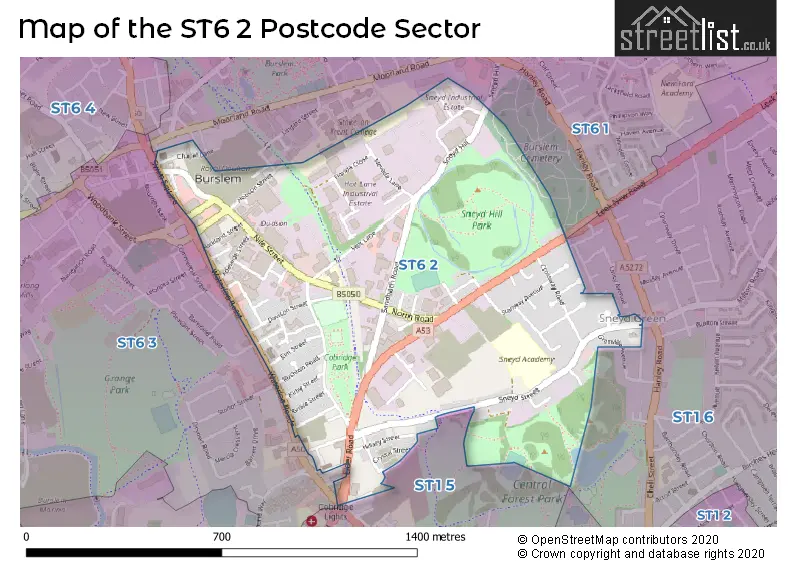
The ST6 2 Postcode shares a border with ST1 5 (STOKE-ON-TRENT), ST1 6 (STOKE-ON-TRENT), ST6 1 (STOKE-ON-TRENT, Smallthorne) and ST6 3 (STOKE-ON-TRENT).
The sector is within the post town of STOKE-ON-TRENT.
ST6 2 is a postcode sector within the ST6 postcode district which is within the ST Stoke-on-Trent postcode area.
The Royal Mail delivery office for the ST6 2 postal sector is the Burslem Delivery Office.
The area of the ST6 2 postcode sector is 0.57 square miles which is 1.48 square kilometres or 364.49 square acres.

Map of the ST6 2 Postcode Sector
Explore the ST6 2 postcode sector by using our free interactive map.
| S | T | 6 | - | 2 | X | X |
| S | T | 6 | Space | 2 | Letter | Letter |
Official List of Streets
STOKE-ON-TRENT (69 Streets)
Hot Lane Industrial Estate (5 Streets)
Unofficial Streets or Alternative Spellings
Stockton Brook
LEEK NEW ROADSTOKE-ON-TRENT
ARTHUR BROCKLEHURST WAY BURSLEY ROAD CLEVELAND STREET COBRIDGE ROAD COMMERCIAL STREET DAIRYFIELDS WAY DOUGLAS STREET ERNEST TYRER AVENUE GRANVILLE AVENUE HARRY EATON GROVE HENRY DUNN AVENUE LINGARD STREET QUEEN STREET STONOR STREET BETTANY ROAD BROWN STREET DOBSON STREET DOULTON STREET ELDER PLACE HAWTHORN STREET HOBART STREET HOLECROFT STREET MACINTYRE STREET MARTIN STREET MASSEY SQUARE MAYER BANK PURBECK STREET SILVESTER STREET SPA STREET SUDLOW STREET ZION STREETWeather Forecast for ST6 2
Press Button to Show Forecast for Burslem
| Time Period | Icon | Description | Temperature | Rain Probability | Wind |
|---|---|---|---|---|---|
| 09:00 to 12:00 | Cloudy | 6.0°C (feels like 5.0°C) | 5.00% | ESE 4 mph | |
| 12:00 to 15:00 | Overcast | 8.0°C (feels like 8.0°C) | 10.00% | E 4 mph | |
| 15:00 to 18:00 | Cloudy | 9.0°C (feels like 8.0°C) | 12.00% | E 4 mph | |
| 18:00 to 21:00 | Cloudy | 8.0°C (feels like 7.0°C) | 8.00% | E 4 mph | |
| 21:00 to 00:00 | Partly cloudy (night) | 5.0°C (feels like 2.0°C) | 7.00% | E 7 mph |
Press Button to Show Forecast for Burslem
| Time Period | Icon | Description | Temperature | Rain Probability | Wind |
|---|---|---|---|---|---|
| 00:00 to 03:00 | Cloudy | 3.0°C (feels like 1.0°C) | 11.00% | E 7 mph | |
| 03:00 to 06:00 | Cloudy | 3.0°C (feels like 0.0°C) | 9.00% | E 7 mph | |
| 06:00 to 09:00 | Cloudy | 4.0°C (feels like 1.0°C) | 9.00% | ENE 7 mph | |
| 09:00 to 12:00 | Cloudy | 7.0°C (feels like 4.0°C) | 9.00% | E 9 mph | |
| 12:00 to 15:00 | Cloudy | 9.0°C (feels like 6.0°C) | 18.00% | E 9 mph | |
| 15:00 to 18:00 | Cloudy | 10.0°C (feels like 7.0°C) | 18.00% | E 9 mph | |
| 18:00 to 21:00 | Cloudy | 9.0°C (feels like 7.0°C) | 18.00% | ENE 9 mph | |
| 21:00 to 00:00 | Cloudy | 6.0°C (feels like 4.0°C) | 16.00% | ENE 9 mph |
Press Button to Show Forecast for Burslem
| Time Period | Icon | Description | Temperature | Rain Probability | Wind |
|---|---|---|---|---|---|
| 00:00 to 03:00 | Cloudy | 6.0°C (feels like 3.0°C) | 20.00% | NE 9 mph | |
| 03:00 to 06:00 | Overcast | 6.0°C (feels like 3.0°C) | 23.00% | NNE 11 mph | |
| 06:00 to 09:00 | Heavy rain | 6.0°C (feels like 3.0°C) | 71.00% | NNE 11 mph | |
| 09:00 to 12:00 | Heavy rain | 7.0°C (feels like 4.0°C) | 77.00% | NNE 11 mph | |
| 12:00 to 15:00 | Heavy rain | 8.0°C (feels like 5.0°C) | 76.00% | N 11 mph | |
| 15:00 to 18:00 | Heavy rain | 9.0°C (feels like 6.0°C) | 72.00% | N 11 mph | |
| 18:00 to 21:00 | Cloudy | 9.0°C (feels like 7.0°C) | 19.00% | N 9 mph | |
| 21:00 to 00:00 | Clear night | 7.0°C (feels like 5.0°C) | 11.00% | WNW 7 mph |
Schools and Places of Education Within the ST6 2 Postcode Sector
North Road Academy
Other independent school
North Road, Stoke-on-trent, Staffordshire, ST6 2BP
Head: Mr Naeem Bashir
Ofsted Rating: Requires improvement
Inspection: 2023-03-02 (421 days ago)
Website: Visit North Road Academy Website
Phone: 01782829870
Number of Pupils: 215
Sneyd Academy
Academy converter
Sneyd Street, Stoke-on-Trent, Staffordshire, ST6 2NS
Head: Mrs Rosina Lee
Ofsted Rating: Good
Inspection: 2023-06-21 (310 days ago)
Website: Visit Sneyd Academy Website
Phone: 01782234460
Number of Pupils: 573
House Prices in the ST6 2 Postcode Sector
| Type of Property | 2018 Average | 2018 Sales | 2017 Average | 2017 Sales | 2016 Average | 2016 Sales | 2015 Average | 2015 Sales |
|---|---|---|---|---|---|---|---|---|
| Detached | £0 | 0 | £241,017 | 3 | £190,000 | 1 | £120,000 | 1 |
| Semi-Detached | £122,122 | 16 | £99,923 | 13 | £101,473 | 13 | £99,732 | 14 |
| Terraced | £55,822 | 43 | £51,254 | 45 | £48,470 | 49 | £50,473 | 28 |
| Flats | £67,500 | 4 | £85,000 | 1 | £0 | 0 | £70,000 | 2 |
Important Postcodes ST6 2 in the Postcode Sector
ST6 2AB is the postcode for Burslem Health Centre, Lucie Wedgwood Health Centre, Chapel Lane, Burslem Health Centre, Lucie Wedgwood Health Centre, and BURSLEM HEALTH CENTRE, CHAPEL LANE, BURSLEM
ST6 2JN is the postcode for Cobridge Community Health Centre, Building A, Church Terrace, Cobridge Community Health Centre, Building B (Sexual Health), Cobridge Community Health Centre, Building A, and Cobridge Community Health Centre, Building B (Sexual Health), Church Terrace
ST6 2NS is the postcode for BUILDING 2, Sneyd Green Primary School, Sneyd Street, MAIN SCHOOL BLOCK, Sneyd Green Primary School, Sneyd Street, and Sneyd Green Primary School, Sneyd Street
| The ST6 2 Sector is within these Local Authorities |
|
|---|---|
| The ST6 2 Sector is within these Counties |
|
| The ST6 2 Sector is within these Water Company Areas |
|