The TA19 0 postcode sector is within the county of Somerset.
Did you know? According to the 2021 Census, the TA19 0 postcode sector is home to a bustling 5,791 residents!
Given that each sector allows for 400 unique postcode combinations. Letters C, I, K, M, O and V are not allowed in the last two letters of a postcode. With 206 postcodes already in use, this leaves 194 units available.
The largest settlement in the TA19 0 postal code is ILMINSTER followed by Shepton Beauchamp, and Seavington.
The TA19 0 Postcode shares a border with TA10 0 (Curry Rivel, Hambridge, Drayton), TA12 6 (MARTOCK, Kingsbury Episcopi, Bower Hinton), TA13 5 (SOUTH PETHERTON, Lopen, Over Stratton), TA17 8 (HINTON ST. GEORGE, Dinnington, Allowenshay), TA3 6 (North Curry, Stoke St. Gregory, Fivehead), TA19 9 (ILMINSTER, Ilton, Horton), TA20 3 (Combe St. Nicholas, Buckland St. Mary, Wadeford) and TA20 4 (Winsham, Thorncombe, Chard Junction).
The sector is within the post town of ILMINSTER.
TA19 0 is a postcode sector within the TA19 postcode district which is within the TA Taunton postcode area.
The Royal Mail delivery office for the TA19 0 postal sector is the Ilminster Scale Payment Delivery Office.
The area of the TA19 0 postcode sector is 14.48 square miles which is 37.50 square kilometres or 9,267.35 square acres.
The TA19 0 postcode sector is crossed by the A303 Major A road.
Waterways within the TA19 0 postcode sector include the Shudrick Stream, Westport Canal, River Isle.

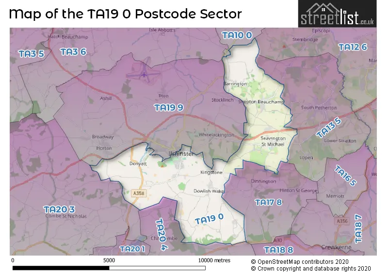
Map of the TA19 0 Postcode Sector
Explore the TA19 0 postcode sector by using our free interactive map.
| T | A | 1 | 9 | - | 0 | X | X |
| T | A | 1 | 9 | Space | 0 | Letter | Letter |
Official List of Streets
ILMINSTER (45 Streets)
Dowlish Wake (3 Streets)
Shepton Beauchamp (18 Streets)
Seavington (11 Streets)
Donyatt (5 Streets)
Cricket Malherbie (1 Streets)
Barrington (9 Streets)
Dowlish Ford (2 Streets)
Moolham (1 Streets)
Unofficial Streets or Alternative Spellings
Shepton Beauchamp
BELMONT TERRACE THE SHAMBLESWestport
RUSKWAY LANEILMINSTER
CANAL WAY CORNHILL HIGH STREET MIANDA TERRACE SUMMERLANDS PARK AVENUE SUMMERLANDS PARK DRIVEHorton
SHAVE LANEWeather Forecast for TA19 0
Press Button to Show Forecast for South Petherton
| Time Period | Icon | Description | Temperature | Rain Probability | Wind |
|---|---|---|---|---|---|
| 12:00 to 15:00 | Light rain | 9.0°C (feels like 6.0°C) | 50.00% | E 11 mph | |
| 15:00 to 18:00 | Light rain | 8.0°C (feels like 6.0°C) | 57.00% | E 9 mph | |
| 18:00 to 21:00 | Light rain | 8.0°C (feels like 6.0°C) | 50.00% | E 7 mph | |
| 21:00 to 00:00 | Light rain | 7.0°C (feels like 5.0°C) | 53.00% | NE 7 mph |
Press Button to Show Forecast for South Petherton
| Time Period | Icon | Description | Temperature | Rain Probability | Wind |
|---|---|---|---|---|---|
| 00:00 to 03:00 | Light rain | 7.0°C (feels like 5.0°C) | 48.00% | ENE 7 mph | |
| 03:00 to 06:00 | Overcast | 7.0°C (feels like 5.0°C) | 19.00% | NE 4 mph | |
| 06:00 to 09:00 | Overcast | 6.0°C (feels like 4.0°C) | 13.00% | ENE 7 mph | |
| 09:00 to 12:00 | Overcast | 8.0°C (feels like 5.0°C) | 13.00% | ENE 9 mph | |
| 12:00 to 15:00 | Overcast | 10.0°C (feels like 8.0°C) | 19.00% | NE 9 mph | |
| 15:00 to 18:00 | Light rain | 11.0°C (feels like 9.0°C) | 48.00% | NNE 9 mph | |
| 18:00 to 21:00 | Cloudy | 10.0°C (feels like 8.0°C) | 52.00% | NNE 9 mph | |
| 21:00 to 00:00 | Light rain | 8.0°C (feels like 6.0°C) | 54.00% | NNE 11 mph |
Press Button to Show Forecast for South Petherton
| Time Period | Icon | Description | Temperature | Rain Probability | Wind |
|---|---|---|---|---|---|
| 00:00 to 03:00 | Heavy rain | 7.0°C (feels like 4.0°C) | 84.00% | N 11 mph | |
| 03:00 to 06:00 | Heavy rain | 7.0°C (feels like 3.0°C) | 88.00% | N 13 mph | |
| 06:00 to 09:00 | Heavy rain | 6.0°C (feels like 3.0°C) | 88.00% | NNW 11 mph | |
| 09:00 to 12:00 | Heavy rain | 8.0°C (feels like 5.0°C) | 76.00% | NNW 11 mph | |
| 12:00 to 15:00 | Cloudy | 11.0°C (feels like 8.0°C) | 14.00% | NW 11 mph | |
| 15:00 to 18:00 | Cloudy | 12.0°C (feels like 10.0°C) | 11.00% | WNW 9 mph | |
| 18:00 to 21:00 | Partly cloudy (day) | 11.0°C (feels like 9.0°C) | 2.00% | WNW 7 mph | |
| 21:00 to 00:00 | Clear night | 6.0°C (feels like 5.0°C) | 5.00% | WSW 4 mph |
Press Button to Show Forecast for South Petherton
| Time Period | Icon | Description | Temperature | Rain Probability | Wind |
|---|---|---|---|---|---|
| 00:00 to 03:00 | Clear night | 5.0°C (feels like 3.0°C) | 0.00% | SSW 4 mph | |
| 03:00 to 06:00 | Clear night | 4.0°C (feels like 2.0°C) | 1.00% | S 4 mph | |
| 06:00 to 09:00 | Partly cloudy (day) | 7.0°C (feels like 5.0°C) | 1.00% | SSE 7 mph | |
| 09:00 to 12:00 | Cloudy | 11.0°C (feels like 9.0°C) | 6.00% | S 13 mph | |
| 12:00 to 15:00 | Cloudy | 13.0°C (feels like 10.0°C) | 6.00% | S 16 mph | |
| 15:00 to 18:00 | Partly cloudy (day) | 13.0°C (feels like 10.0°C) | 3.00% | S 16 mph | |
| 18:00 to 21:00 | Sunny day | 12.0°C (feels like 9.0°C) | 5.00% | SSE 11 mph | |
| 21:00 to 00:00 | Partly cloudy (night) | 10.0°C (feels like 7.0°C) | 4.00% | SE 11 mph |
Press Button to Show Forecast for South Petherton
| Time Period | Icon | Description | Temperature | Rain Probability | Wind |
|---|---|---|---|---|---|
| 00:00 to 03:00 | Partly cloudy (night) | 9.0°C (feels like 7.0°C) | 5.00% | SE 11 mph | |
| 03:00 to 06:00 | Clear night | 9.0°C (feels like 7.0°C) | 7.00% | SE 11 mph | |
| 06:00 to 09:00 | Sunny day | 10.0°C (feels like 7.0°C) | 11.00% | SE 11 mph | |
| 09:00 to 12:00 | Partly cloudy (day) | 13.0°C (feels like 10.0°C) | 13.00% | SE 13 mph | |
| 12:00 to 15:00 | Partly cloudy (day) | 14.0°C (feels like 11.0°C) | 15.00% | SSE 13 mph | |
| 15:00 to 18:00 | Cloudy | 14.0°C (feels like 12.0°C) | 16.00% | SE 13 mph | |
| 18:00 to 21:00 | Sunny day | 13.0°C (feels like 11.0°C) | 11.00% | SE 9 mph | |
| 21:00 to 00:00 | Cloudy | 10.0°C (feels like 9.0°C) | 10.00% | SE 7 mph |
Schools and Places of Education Within the TA19 0 Postcode Sector
Herne View Church of England Primary
Voluntary controlled school
Ditton Street, Ilminster, , TA19 0BL
Head: Miss Claire Oaten
Ofsted Rating: Good
Inspection: 2022-11-30 (513 days ago)
Website: Visit Herne View Church of England Primary Website
Phone: 0146052686
Number of Pupils: 491
House Prices in the TA19 0 Postcode Sector
| Type of Property | 2018 Average | 2018 Sales | 2017 Average | 2017 Sales | 2016 Average | 2016 Sales | 2015 Average | 2015 Sales |
|---|---|---|---|---|---|---|---|---|
| Detached | £427,921 | 38 | £404,756 | 39 | £346,582 | 36 | £368,405 | 38 |
| Semi-Detached | £237,767 | 30 | £237,754 | 42 | £235,100 | 46 | £215,220 | 41 |
| Terraced | £211,316 | 41 | £197,889 | 55 | £181,259 | 45 | £192,953 | 33 |
| Flats | £128,467 | 13 | £158,200 | 11 | £103,094 | 16 | £145,136 | 11 |
Important Postcodes TA19 0 in the Postcode Sector
TA19 0BL is the postcode for Herne View Church Of England Primary School, Ditton Street, Swanmead Community School, Ditton Street, and BLOCK A, Swanmead Community School, Ditton Street
TA19 0DS is the postcode for Greenfylde First School, Silver Street, and Herne View Church Of England Primary School, Silver Street
TA19 0LQ is the postcode for Shepton Beauchamp Primary School, Church Street, Shepton Beauchamp
| The TA19 0 Sector is within these Local Authorities |
|
|---|---|
| The TA19 0 Sector is within these Counties |
|
| The TA19 0 Sector is within these Water Company Areas |
|
Tourist Attractions within the TA19 0 Postcode Area
We found 1 visitor attractions within the TA19 postcode area
| Barrington Court |
|---|
| Historic Properties |
| Historic House / House and Garden / Palace |
| View Barrington Court on Google Maps |