The TF10 7 postcode sector stands on the Shropshire and Staffordshire border.
Did you know? According to the 2021 Census, the TF10 7 postcode sector is home to a bustling 12,478 residents!
Given that each sector allows for 400 unique postcode combinations. Letters C, I, K, M, O and V are not allowed in the last two letters of a postcode. With 318 postcodes already in use, this leaves 82 units available.
The TF10 7 postal code covers the settlement of NEWPORT.
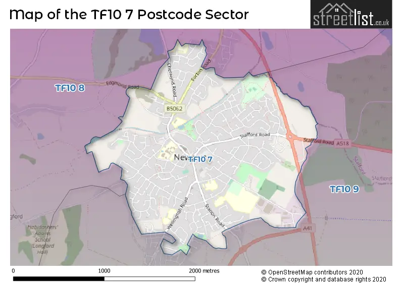
The TF10 7 Postcode shares a border with TF10 8 (Edgmond, Tibberton, NEWPORT) and TF10 9 (Lilleshall, Church Aston, Moreton).
The sector is within the post town of NEWPORT.
TF10 7 is a postcode sector within the TF10 postcode district which is within the TF Telford postcode area.
The Royal Mail delivery office for the TF10 7 postal sector is the Newport (tf) Delivery Office.
The area of the TF10 7 postcode sector is 1.39 square miles which is 3.60 square kilometres or 890.07 square acres.

Map of the TF10 7 Postcode Sector
Explore the TF10 7 postcode sector by using our free interactive map.
| T | F | 1 | 0 | - | 7 | X | X |
| T | F | 1 | 0 | Space | 7 | Letter | Letter |
Official List of Streets
NEWPORT (173 Streets)
Unofficial Streets or Alternative Spellings
NEWPORT
BEECHFIELDS WAY MARKET MEWS PINE TREES THE SQUAREChurch Aston
GREENVALE MOORFIELD LANE WALLSHEAD WAY WELLINGTON ROAD AUDLEY HOUSE MEWS BELLMANS YARD COCK YARD DARK LANE DUN COW YARD NEWBOROUGH COURT PEN-Y-BRYN WAY SANDYCROFT SCHOOL GROUND LANE SHUKERS CLOSE THE MALTINGS THE OLD QUARRY TOWN WELLS TRINITY COURT TRINITY MEWS WELLS MEWSChetwynd
CHESTER ROADWeather Forecast for TF10 7
Press Button to Show Forecast for Newport (Telford & Wrekin)
| Time Period | Icon | Description | Temperature | Rain Probability | Wind |
|---|---|---|---|---|---|
| 15:00 to 18:00 | Light rain shower (day) | 23.0°C (feels like 21.0°C) | 34.00% | SE 9 mph | |
| 18:00 to 21:00 | Light rain shower (day) | 19.0°C (feels like 19.0°C) | 36.00% | WSW 4 mph | |
| 21:00 to 00:00 | Light rain shower (night) | 16.0°C (feels like 16.0°C) | 30.00% | ESE 4 mph |
Press Button to Show Forecast for Newport (Telford & Wrekin)
| Time Period | Icon | Description | Temperature | Rain Probability | Wind |
|---|---|---|---|---|---|
| 00:00 to 03:00 | Partly cloudy (night) | 14.0°C (feels like 14.0°C) | 2.00% | SE 2 mph | |
| 03:00 to 06:00 | Cloudy | 13.0°C (feels like 12.0°C) | 4.00% | SSW 4 mph | |
| 06:00 to 09:00 | Cloudy | 13.0°C (feels like 12.0°C) | 6.00% | S 7 mph | |
| 09:00 to 12:00 | Cloudy | 16.0°C (feels like 13.0°C) | 5.00% | S 11 mph | |
| 12:00 to 15:00 | Cloudy | 18.0°C (feels like 15.0°C) | 5.00% | SSE 13 mph | |
| 15:00 to 18:00 | Cloudy | 19.0°C (feels like 16.0°C) | 10.00% | SSE 16 mph | |
| 18:00 to 21:00 | Cloudy | 17.0°C (feels like 14.0°C) | 14.00% | SSE 13 mph | |
| 21:00 to 00:00 | Light rain | 15.0°C (feels like 13.0°C) | 52.00% | SE 11 mph |
Press Button to Show Forecast for Newport (Telford & Wrekin)
| Time Period | Icon | Description | Temperature | Rain Probability | Wind |
|---|---|---|---|---|---|
| 00:00 to 03:00 | Light rain | 14.0°C (feels like 13.0°C) | 58.00% | SE 9 mph | |
| 03:00 to 06:00 | Light rain | 14.0°C (feels like 12.0°C) | 57.00% | ESE 9 mph | |
| 06:00 to 09:00 | Light rain | 14.0°C (feels like 12.0°C) | 58.00% | ESE 9 mph | |
| 09:00 to 12:00 | Heavy rain | 15.0°C (feels like 13.0°C) | 84.00% | ESE 9 mph | |
| 12:00 to 15:00 | Heavy rain | 16.0°C (feels like 14.0°C) | 85.00% | SE 9 mph | |
| 15:00 to 18:00 | Light rain shower (day) | 16.0°C (feels like 15.0°C) | 47.00% | SSE 9 mph | |
| 18:00 to 21:00 | Cloudy | 16.0°C (feels like 14.0°C) | 24.00% | SE 9 mph | |
| 21:00 to 00:00 | Cloudy | 13.0°C (feels like 12.0°C) | 13.00% | SE 7 mph |
Press Button to Show Forecast for Newport (Telford & Wrekin)
| Time Period | Icon | Description | Temperature | Rain Probability | Wind |
|---|---|---|---|---|---|
| 00:00 to 03:00 | Cloudy | 12.0°C (feels like 11.0°C) | 8.00% | ESE 7 mph | |
| 03:00 to 06:00 | Partly cloudy (night) | 11.0°C (feels like 10.0°C) | 3.00% | ESE 7 mph | |
| 06:00 to 09:00 | Cloudy | 12.0°C (feels like 11.0°C) | 8.00% | ESE 7 mph | |
| 09:00 to 12:00 | Partly cloudy (day) | 15.0°C (feels like 14.0°C) | 11.00% | SE 9 mph | |
| 12:00 to 15:00 | Light rain shower (day) | 17.0°C (feels like 16.0°C) | 36.00% | SE 9 mph | |
| 15:00 to 18:00 | Partly cloudy (day) | 19.0°C (feels like 17.0°C) | 35.00% | SE 9 mph | |
| 18:00 to 21:00 | Sunny day | 18.0°C (feels like 17.0°C) | 8.00% | SSE 7 mph | |
| 21:00 to 00:00 | Clear night | 13.0°C (feels like 12.0°C) | 2.00% | SSE 4 mph |
Press Button to Show Forecast for Newport (Telford & Wrekin)
| Time Period | Icon | Description | Temperature | Rain Probability | Wind |
|---|---|---|---|---|---|
| 00:00 to 03:00 | Clear night | 11.0°C (feels like 11.0°C) | 2.00% | SSE 4 mph | |
| 03:00 to 06:00 | Clear night | 10.0°C (feels like 9.0°C) | 3.00% | SE 4 mph | |
| 06:00 to 09:00 | Sunny day | 12.0°C (feels like 12.0°C) | 4.00% | SSE 4 mph | |
| 09:00 to 12:00 | Partly cloudy (day) | 16.0°C (feels like 16.0°C) | 5.00% | SSE 4 mph | |
| 12:00 to 15:00 | Cloudy | 19.0°C (feels like 18.0°C) | 12.00% | SW 4 mph | |
| 15:00 to 18:00 | Cloudy | 19.0°C (feels like 18.0°C) | 15.00% | WSW 4 mph | |
| 18:00 to 21:00 | Light rain shower (day) | 18.0°C (feels like 17.0°C) | 32.00% | WNW 7 mph | |
| 21:00 to 00:00 | Partly cloudy (night) | 14.0°C (feels like 13.0°C) | 4.00% | WNW 7 mph |
Schools and Places of Education Within the TF10 7 Postcode Sector
Haberdashers' Adams
Academy converter
High Street, Newport, Shropshire, TF10 7BD
Head: Mr Gary Hickey
Ofsted Rating: Good
Inspection: 2022-05-10 (733 days ago)
Website: Visit Haberdashers' Adams Website
Phone: 01952953810
Number of Pupils: 1055
Moorfield Primary School
Foundation school
Wellington Road, Newport, Shropshire, TF10 7QU
Head: Mr Ian Bussey
Ofsted Rating: Outstanding
Inspection: 2014-03-20 (3706 days ago)
Website: Visit Moorfield Primary School Website
Phone: 01952386470
Number of Pupils: 278
Newport Church of England Voluntary Controlled Junior School
Voluntary controlled school
Avenue Road, Newport, Shropshire, TF10 7EA
Head: Mrs Nicola Moody
Ofsted Rating: Good
Inspection: 2023-12-07 (157 days ago)
Website: Visit Newport Church of England Voluntary Controlled Junior School Website
Phone: 01952386600
Number of Pupils: 325
Newport Girls' High School Academy
Academy converter
Wellington Road, Newport, Shropshire, TF10 7HL
Head: Mr Michael Scott
Ofsted Rating: Outstanding
Inspection: 2022-11-02 (557 days ago)
Website: Visit Newport Girls' High School Academy Website
Phone: 01952797550
Number of Pupils: 737
Newport Infant School and Nursery
Community school
Granville Avenue, Newport, Shropshire, TF10 7DX
Head: Mrs Emma Heeley
Ofsted Rating: Good
Inspection: 2023-11-16 (178 days ago)
Website: Visit Newport Infant School and Nursery Website
Phone: 01952386610
Number of Pupils: 255
St Peter and St Paul Catholic Primary School
Voluntary aided school
Coppice Drive, Newport, Shropshire, TF10 7HU
Head: Miss Sarah Staniforth
Ofsted Rating: Outstanding
Inspection: 2012-12-06 (4175 days ago)
Website: Visit St Peter and St Paul Catholic Primary School Website
Phone: 01952386450
Number of Pupils: 197
House Prices in the TF10 7 Postcode Sector
| Type of Property | 2018 Average | 2018 Sales | 2017 Average | 2017 Sales | 2016 Average | 2016 Sales | 2015 Average | 2015 Sales |
|---|---|---|---|---|---|---|---|---|
| Detached | £284,383 | 128 | £269,046 | 145 | £258,436 | 140 | £240,953 | 120 |
| Semi-Detached | £180,330 | 93 | £178,556 | 84 | £179,163 | 99 | £165,982 | 101 |
| Terraced | £163,272 | 40 | £156,126 | 66 | £163,363 | 50 | £145,099 | 71 |
| Flats | £117,056 | 18 | £115,585 | 17 | £118,592 | 20 | £96,684 | 32 |
Important Postcodes TF10 7 in the Postcode Sector
TF10 7AT is the postcode for Telford and Wrekin Council, Newport Library
TF10 7BD is the postcode for Adams Grammar School, High Street, SPORTS HALL, Adams Grammar School, High Street, and MAIN CLASSROOM BLOCK, Adams Grammar School, High Street
TF10 7DS is the postcode for MAIN SCHOOL, Burton Borough School, Audley Avenue, MUSIC HALL, Burton Borough School, Audley Avenue, SPORTS HALL, Burton Borough School, Audley Avenue, Burton Borough School, Audley Avenue, and STEM BLOCK, Burton Borough School, Audley Avenue
TF10 7DX is the postcode for NEWPORT INFANT SCHOOL, GRANVILLE AVENUE, NEWPORT, and Newport Infant School, Granville Avenue
TF10 7EA is the postcode for Newport Junior School, Avenue Road, MAIN BUILDING, Newport Junior School, Avenue Road, and LARGE VICTORIAN BUILDING, Newport Junior School, Avenue Road
TF10 7EN is the postcode for LINDEN HALL SURGERY, STATION ROAD
TF10 7HL is the postcode for Newport Girls High School, Wellington Road
TF10 7HU is the postcode for St. Peter & St. Paul Catholic Primary School, Coppice Drive, and ST PETER AND ST PAUL RC PRIMARY SCHOOL, COPPICE DRIVE, NEWPORT
TF10 7LB is the postcode for Shropshire Fire & Rescue Service, Fire Station, Salters Lane
TF10 7LH is the postcode for NEWPORT SWIMMING POOL, VICTORIA PARK, NEWPORT, Telford & Wrekin Council, Newport Swimming Pool, Victoria Park, and Newport Swimming Pool, Victoria Park
TF10 7QU is the postcode for MAIN BUILDING, Moorfield Primary School, Wellington Road, and Moorfield Primary School, Wellington Road
| The TF10 7 Sector is within these Local Authorities |
|
|---|---|
| The TF10 7 Sector is within these Counties |
|
| The TF10 7 Sector is within these Water Company Areas |
|