Author:


A wide range of spatial data has been analysed to present this overview of the TF10 9 Postcode sector. If you would like anything added, please contact us.

The TF10 9 Newport Postcode Sector


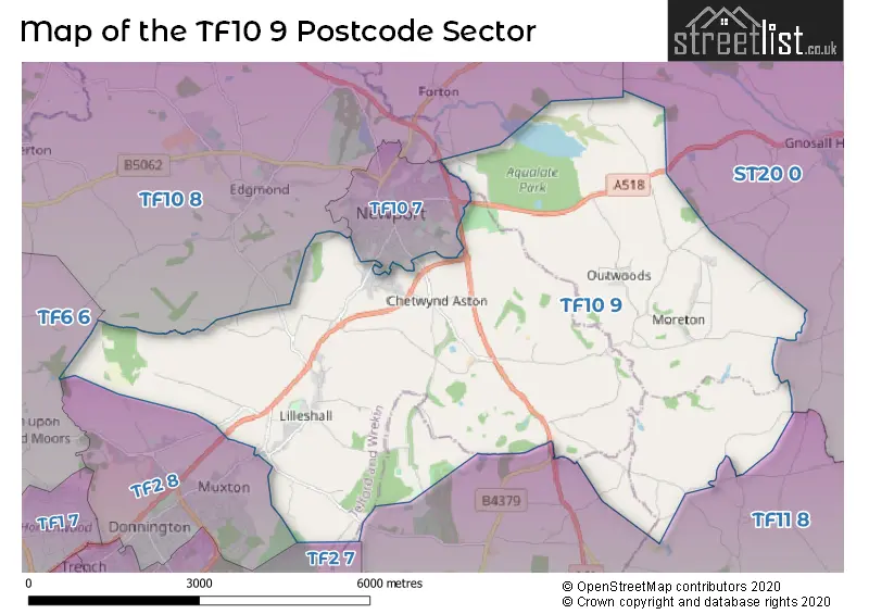
The TF10 9 postcode sector stands on the Shropshire and Staffordshire border.

Did you know? According to the 2021 Census, the TF10 9 postcode sector is home to a bustling 3,548 residents!

Given that each sector allows for 400 unique postcode combinations. Letters C, I, K, M, O and V are not allowed in the last two letters of a postcode. With 136 postcodes already in use, this leaves 264 units available.

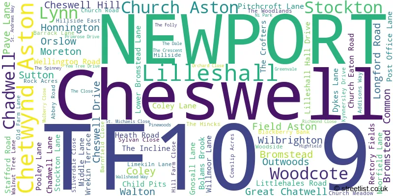
The largest settlement in the TF10 9 postal code is Lilleshall followed by Church Aston, and Moreton.

The TF10 9 Postcode shares a border with TF2 7 (Donnington, Trench, Donnington Wood), TF2 8 (Donnington, Muxton, TELFORD), TF6 6 (High Ercall, Waters Upton, Crudgington), TF10 7 (NEWPORT), TF10 8 (Edgmond, Tibberton, NEWPORT), TF11 8 (SHIFNAL, Weston-under-Lizard, Sheriffhales) and ST20 0 (Gnosall, Church Eaton, Woodseaves).

Map of the TF10 9 Postcode Sector

Explore the TF10 9 postcode sector by using our interactive map.

The sector is within the post town of NEWPORT.

TF10 9 is a postcode sector within the TF10 postcode district which is within the TF Telford postcode area.

The Royal Mail delivery office for the TF10 9 postal sector is the Newport (tf) Delivery Office.

The area of the TF10 9 postcode sector is 20.13 square miles which is 52.12 square kilometres or 12,880.02 square acres.

Advertisement

Your support helps keep this site running!

If you enjoy using this website, consider buying me a coffee to help cover hosting costs.

Map Showing Location of the TF10 postcode Sector
Where is the TF10 Postcode Sector?
A word cloud for the TF10 9 postcode
A word cloud showing place names for the TF10 9 postcode sector, can you see your street?
Postcode format for the TF10 9 postcode sector
T F 1 0 - 9 X X
T F 1 0 Space 9 Letter Letter
Advertisement

Street List for TF10 9

ABBEY ROAD
C-Road

LILLESHALL, Newport, Shropshire

Minor Road USRN:45200003

ADDISONS WAY

LILLESHALL, Newport, Shropshire

Restricted Local Access Road USRN:45200900

BARNFIELD CLOSE

CHURCH ASTON, Newport, Shropshire

Local Road USRN:45224995

BARRACK LANE

LILLESHALL, Newport, Shropshire

Local Road USRN:45200116

BIRCHEY COPPICE
C-Road

Moreton, Staffordshire

Minor Road USRN:37601874

BLACKBERRY BANK

CHURCH ASTON, Newport, Shropshire

Local Road USRN:45200159

BLUEBELL LANE

Newport, Shropshire

Local Road USRN:45224896

BROMSTEAD COMMON LANE

Bromstead Heath, Staffordshire

Local Road USRN:37602050

BROMSTEAD LANE
C-Road

Bromstead Heath, Staffordshire

Minor Road USRN:37601945

BUN LANE
C-Road

Great Chatwell, Staffordshire

Minor Road USRN:36701445

CHATWELL LANE
C-Road

WESTON CROSS ROADS, Blymhill, Shropshire

Minor Road USRN:4300862

CHATWELL LANE
C-Road

WESTON CROSS ROADS, Blymhill, Staffordshire

Minor Road USRN:4300862

CHATWELL LANE
C-Road

Great Chatwell, Staffordshire

Minor Road USRN:36700715

CHESWELL DRIVE
C-Road

CHESWELL, Newport, Shropshire

Minor Road USRN:45200739

CHILD PIT LANE

LILLESHALL, Newport, Shropshire

Local Access Road USRN:4310045

CHILD PIT LANE

LILLESHALL, Newport, Shropshire

Local Access Road USRN:45200727

CHURCH EATON ROAD
C-Road

Bromstead, Staffordshire

Minor Road USRN:37601829

CHURCH LANE
C-Road

Bromstead Heath, Staffordshire

Minor Road USRN:37601943

CHURCH MEADOW

LILLESHALL, Newport, Shropshire

Local Road USRN:45200388

CHURCH ROAD
C-Road

LILLESHALL, Newport, Shropshire

Minor Road USRN:45200395

COWSLIP ACRES

Newport, Shropshire

Local Road USRN:45224901

CROSS LANE

Bromstead Heath, Staffordshire

Local Road USRN:37601811

DAISY CLOSE

Newport, Shropshire

Local Road USRN:45224897

DARK LANE

CHURCH ASTON, Newport, Shropshire

USRN:45210596

DONNINGTON DRIVE

THE HUMBERS, Telford, Shropshire

Local Road USRN:45200551

DYKES LANE

Moreton, Staffordshire

Local Road USRN:37602284

EASTUN CLOSE

Newport, Shropshire

Local Road USRN:45227464

FARMERS GATE

Newport, Shropshire

Local Road USRN:45224899

FIELD ASTON LANE

FIELD ASTON, Newport, Shropshire

Local Road USRN:45210597

GNOSALL LANE
C-Road

Moreton, Staffordshire

Minor Road USRN:37601871

GNOSALL ROAD
C-Road

Beffcote, Staffordshire

Minor Road USRN:37601814

GREAT CHATWELL
C-Road

Newport, Shropshire

Minor Road USRN:36700047

GREAT CHATWELL
C-Road

Newport, Staffordshire

Minor Road USRN:36700047

GREENFIELDS DRIVE

Newport, Shropshire

Local Road USRN:45224895

GREENVALE

CHURCH ASTON, Newport, Shropshire

Local Road USRN:45210379

GROVE GARDENS

Newport, Shropshire

Local Road USRN:45227151

GUILD LANE
C-Road

Aqualate, Staffordshire

Minor Road USRN:37601076

HEATH ROAD
C-Road

Bromstead Heath, Staffordshire

Minor Road USRN:37601872

HIGHFIELD

CHURCH ASTON, Newport, Shropshire

Local Road USRN:45200872

HILL FARM CLOSE

LILLESHALL, Newport, Shropshire

Local Road USRN:45224855

HILLSIDE

LILLESHALL, Newport, Shropshire

Local Road USRN:45200886

HILLSIDE EAST

LILLESHALL, Newport, Shropshire

Local Road USRN:45224574

HUTCHISON LANE

Newport, Shropshire

Local Road USRN:45227463

KELLER DRIVE

Newport, Shropshire

Restricted Local Access Road USRN:45225240

KINGS STREET
C-Road

Great Chatwell, Staffordshire

Minor Road USRN:36701621

KYNNERSLEY DRIVE
C-Road

LILLESHALL, Newport, Shropshire

Minor Road USRN:45201887

LILLESHALL HALL DRIVE

LILLESHALL, Newport, Shropshire

Local Access Road USRN:45225195

LILLESHALL HALL DRIVE

LILLESHALL, Newport, Shropshire

Local Access Road USRN:4310099

LILYHURST ROAD
C-Road

LILLESHALL, Newport, Shropshire

Minor Road USRN:45210625

LIMEKILN LANE
C-Road

LILLESHALL, Newport, Shropshire

Minor Road USRN:45201067

LITTLEHALES ROAD
C-Road

CHETWYND ASTON, Newport, Shropshire

Minor Road USRN:45201082

LITTLEHALES ROAD

Sheriffhales, Shropshire

Local Access Road USRN:4300385

LODGE ROAD

DONNINGTON WOOD, Telford, Shropshire

Local Road USRN:45201087

LONGFORD ROAD
C-Road

Newport, Shropshire

Minor Road USRN:45201095

LOWER BROMSTEAD LANE
C-Road

Bromstead Heath, Staffordshire

Minor Road USRN:37601944

LOWER BROMSTEAD ROAD
C-Road

Moreton, Staffordshire

Minor Road USRN:37601873

LYNN LANE

Great Chatwell, Shropshire

Restricted Local Access Road USRN:36700244

LYNN LANE

Great Chatwell, Staffordshire

Restricted Local Access Road USRN:36700244

MERETOWN LANE
C-Road

Forton, Staffordshire

Minor Road USRN:37601492

MIDDLE LANE

Bromstead Heath, Staffordshire

Restricted Local Access Road USRN:37602782

MOORFIELD LANE
C-Road

Newport, Shropshire

Minor Road USRN:45201232

MOSS DRIVE

Newport, Shropshire

Local Road USRN:45227460

MULBERRY CLOSE

CHURCH ASTON, Newport, Shropshire

Local Road USRN:45201254

NEW TRENCH ROAD A518
A-Road

TRENCH, Telford, Shropshire

A Road USRN:45210421

NEWPORT ROAD A518
A-Road

Swan Pit, Staffordshire

A Road USRN:37601512

NI PARK

Newport, Shropshire

Local Road USRN:45227387

NURSERY LANE
C-Road

LILLESHALL, Newport, Shropshire

Minor Road USRN:45210599

OLD FARM LANE

LILLESHALL, Newport, Shropshire

Local Road USRN:45201312

ORCHARD CLOSE

CHURCH ASTON, Newport, Shropshire

USRN:45224462

ORSLOW

Newport, Staffordshire

Local Road USRN:36700398

OUTWOODS BANK

OUTWOODS, Newport, Staffordshire

Local Road USRN:37602787

OUTWOODS FARM ROAD

Outwoods, Shropshire

Local Road USRN:37602788

OUTWOODS FARM ROAD

Outwoods, Staffordshire

Local Road USRN:37602788

OUTWOODS LANE

Outwoods, Staffordshire

Local Road USRN:37602789

OUTWOODS ROAD
C-Road

Outwoods, Staffordshire

Minor Road USRN:37602045

PAVE LANE
C-Road

CHETWYND ASTON, Newport, Shropshire

Minor Road USRN:45200386

PINEWOODS

CHURCH ASTON, Newport, Shropshire

Local Road USRN:45201397

PITCHCROFT LANE
C-Road

WOODCOTE, Newport, Shropshire

Minor Road USRN:45201401

PLATINUM WAY

Newport, Shropshire

Local Road USRN:45227459

POOLEY LANE
C-Road

Moreton, Staffordshire

Minor Road USRN:37601825

POST OFFICE LANE
C-Road

Moreton, Staffordshire

Minor Road USRN:37601946

PRIMROSE DRIVE

CHURCH ASTON, Newport, Shropshire

Local Road USRN:45201436

RECTORY FIELDS

CHURCH ASTON, Newport, Shropshire

Local Road USRN:45227124

RICHMOND CLOSE

CHURCH ASTON, Newport, Shropshire

Local Road USRN:45201498

ROCK ACRES
C-Road

LILLESHALL, Newport, Shropshire

Minor Road USRN:45201512

SARAHS LANE

Great Chatwell, Staffordshire

Local Road USRN:36700547

SILVERDALE CLOSE

CHURCH ASTON, Newport, Shropshire

Local Road USRN:45201621

ST ANDREWS WAY

CHURCH ASTON, Newport, Shropshire

Local Road USRN:45201687

ST GEORGE WAY

Newport, Shropshire

Local Road USRN:45224898

ST MICHAELS CLOSE

LILLESHALL, Newport, Shropshire

Local Road USRN:45201714

STAFFORD ROAD A518
A-Road

Aqualate, Staffordshire

A Road USRN:37601420

STAFFORD ROAD A518
A-Road

Aqualate, Shropshire

A Road USRN:37601420

STATION ROAD
C-Road

Newport, Shropshire

Minor Road USRN:45201755

STOCKTON LANE

Newport, Shropshire

USRN:45202369

SYLVAN CLOSE

LILLESHALL, Newport, Shropshire

Local Road USRN:45201827

THE CLOSE

CHURCH ASTON, Newport, Shropshire

Local Road USRN:45201864

THE CRESCENT

CHURCH ASTON, Newport, Shropshire

Local Road USRN:45201868

THE DALE
C-Road

CHURCH ASTON, Newport, Shropshire

Minor Road USRN:45201874

THE FOLLY

CHURCH ASTON, Newport, Shropshire

Restricted Local Access Road USRN:45201881

THE INCLINE

LILLESHALL, Newport, Shropshire

Local Access Road USRN:4310170

THE OUTWOODS
C-Road

Outwoods, Staffordshire

Minor Road USRN:37602786

THE SIDINGS

Newport, Shropshire

USRN:45227466

THE SPINNEY

CHURCH ASTON, Newport, Shropshire

Local Road USRN:45201914

THE WOODLANDS

LILLESHALL, Newport, Shropshire

Local Road USRN:45201922

TUDOR LANE

Newport, Shropshire

Local Road USRN:45227461

WALLSHEAD WAY

CHURCH ASTON, Newport, Shropshire

Local Road USRN:45202014

WALNUT TREE LANE

Moreton, Staffordshire

Restricted Local Access Road USRN:37602870

WALTON GRANGE LANE
C-Road

MORETON, Newport, Staffordshire

Minor Road USRN:37601853

WAY FOR THE MILLENNIUM

Stafford, Shropshire

Restricted Local Access Road USRN:37602830

WAY FOR THE MILLENNIUM

Stafford, Staffordshire

Restricted Local Access Road USRN:37602830

WELLINGTON ROAD
C-Road

CHURCH ASTON, Newport, Shropshire

Minor Road USRN:45224563

WELLINGTON ROAD
C-Road

HONNINGTON, Telford, Shropshire

Minor Road USRN:45224573

WELLINGTON ROAD A518
A-Road

LILLESHALL, Newport, Shropshire

A Road USRN:45224562

WHARF DRIVE

Newport, Shropshire

Local Road USRN:45227462

WILBRIGHTON ROAD
C-Road

Bromstead Heath, Staffordshire

Minor Road USRN:37601833

WILLMOOR LANE

LILLESHALL, Newport, Shropshire

Local Road USRN:45202095

WOODSIDE

LILLESHALL, Newport, Shropshire

USRN:45227045

WRIGHT AVENUE

Newport, Shropshire

Local Road USRN:45225477

WYNFORD LANE
C-Road

Brineton, Staffordshire

Minor Road USRN:36700495

YEOMANRY WAY

Newport, Shropshire

Local Road USRN:45227352

YEW TREE DRIVE

LILLESHALL, Newport, Shropshire

Local Road USRN:45202163

Weather Forecast for TF10 9

Weather Forecast for Newport (Telford & Wrekin)

Time PeriodIconDescriptionTemperatureRain ProbabilityWind
06:00 to 09:00symbol for Partly cloudy (day)Partly cloudy (day)14.0°C (feels like 13.0°C) 1.00%SW 7 mph
09:00 to 12:00symbol for Sunny daySunny day18.0°C (feels like 16.0°C) 0.00%WSW 11 mph
12:00 to 15:00symbol for Sunny daySunny day21.0°C (feels like 18.0°C) 1.00%WSW 11 mph
15:00 to 18:00symbol for Sunny daySunny day22.0°C (feels like 19.0°C) 1.00%W 13 mph
18:00 to 21:00symbol for CloudyCloudy19.0°C (feels like 17.0°C) 4.00%W 11 mph
21:00 to 00:00symbol for Partly cloudy (night)Partly cloudy (night)16.0°C (feels like 15.0°C) 0.00%W 9 mph

Time PeriodIconDescriptionTemperatureRain ProbabilityWind
00:00 to 03:00symbol for Partly cloudy (night)Partly cloudy (night)14.0°C (feels like 13.0°C) 0.00%WSW 7 mph
03:00 to 06:00symbol for Partly cloudy (night)Partly cloudy (night)13.0°C (feels like 12.0°C) 1.00%WSW 4 mph
06:00 to 09:00symbol for Partly cloudy (day)Partly cloudy (day)15.0°C (feels like 14.0°C) 1.00%W 4 mph
09:00 to 12:00symbol for Partly cloudy (day)Partly cloudy (day)18.0°C (feels like 17.0°C) 1.00%WNW 4 mph
12:00 to 15:00symbol for CloudyCloudy21.0°C (feels like 20.0°C) 4.00%WNW 7 mph
15:00 to 18:00symbol for Sunny daySunny day22.0°C (feels like 20.0°C) 0.00%NW 7 mph
18:00 to 21:00symbol for Sunny daySunny day20.0°C (feels like 18.0°C) 0.00%NW 9 mph
21:00 to 00:00symbol for Clear nightClear night15.0°C (feels like 15.0°C) 0.00%NNW 7 mph

Time PeriodIconDescriptionTemperatureRain ProbabilityWind
00:00 to 03:00symbol for Clear nightClear night12.0°C (feels like 12.0°C) 0.00%NW 4 mph
03:00 to 06:00symbol for Clear nightClear night11.0°C (feels like 10.0°C) 0.00%NW 2 mph
06:00 to 09:00symbol for Sunny daySunny day14.0°C (feels like 14.0°C) 1.00%NE 2 mph
09:00 to 12:00symbol for Sunny daySunny day19.0°C (feels like 19.0°C) 0.00%ESE 4 mph
12:00 to 15:00symbol for Sunny daySunny day23.0°C (feels like 22.0°C) 0.00%SE 4 mph
15:00 to 18:00symbol for Sunny daySunny day25.0°C (feels like 25.0°C) 0.00%ESE 4 mph
18:00 to 21:00symbol for Partly cloudy (day)Partly cloudy (day)25.0°C (feels like 24.0°C) 0.00%ESE 7 mph
21:00 to 00:00symbol for Partly cloudy (night)Partly cloudy (night)20.0°C (feels like 19.0°C) 1.00%ENE 7 mph

Time PeriodIconDescriptionTemperatureRain ProbabilityWind
00:00 to 03:00symbol for Clear nightClear night18.0°C (feels like 16.0°C) 0.00%ESE 9 mph
03:00 to 06:00symbol for Clear nightClear night16.0°C (feels like 15.0°C) 0.00%SE 7 mph
06:00 to 09:00symbol for Sunny daySunny day17.0°C (feels like 16.0°C) 1.00%SE 7 mph
09:00 to 12:00symbol for CloudyCloudy21.0°C (feels like 19.0°C) 4.00%SE 9 mph
12:00 to 15:00symbol for CloudyCloudy24.0°C (feels like 22.0°C) 4.00%SE 9 mph
15:00 to 18:00symbol for CloudyCloudy25.0°C (feels like 24.0°C) 6.00%SSE 9 mph
18:00 to 21:00symbol for Partly cloudy (day)Partly cloudy (day)25.0°C (feels like 24.0°C) 4.00%S 9 mph
21:00 to 00:00symbol for Clear nightClear night20.0°C (feels like 19.0°C) 3.00%SE 7 mph

Schools and Places of Education Within the TF10 9 Postcode Sector

Church Aston Infant School
Community school

Church Aston, Newport, Shropshire, TF10 9JN
Head: Mrs Jenny Griffiths
Ofsted Rating: Good
Inspection: 2018-12-04 (2387 days ago)
Website: Visit Church Aston Infant School Website
Phone: 01952386390
Number of Pupils: 51

Lilleshall Primary School
Community school

Limekiln Lane, Newport, Shropshire, TF10 9EY
Head: Mrs Christobel Cousins
Ofsted Rating: Outstanding
Inspection: 2013-05-03 (4428 days ago)
Website: Visit Lilleshall Primary School Website
Phone: 01952388430
Number of Pupils: 213

Map of the TF10 9 and surrounding postcode sector

House Prices in the TF10 9 Postcode Sector

Yearly House Price Averages for the TF10 9 Postcode Sector
Type of Property 2018 Average 2018 Sales 2017 Average 2017 Sales 2016 Average 2016 Sales 2015 Average 2015 Sales
Detached £485,208 26 £413,583 42 £341,364 49 £316,599 43
Semi-Detached £227,843 21 £194,094 16 £196,133 12 £178,444 9
Terraced £280,250 6 £338,000 4 £214,738 6 £263,571 7
Flats £0 0 £118,500 2 £0 0 £0 0

Important Postcodes TF10 9 in the Postcode Sector

TF10 9AT

TF10 9AT is the postcode for LILLESHALL HALL, LILLESHALL NATIONAL SPORTS CENTRE, LILLESHALL HALL DRIVE, QUEEN ELIZABETH II HALL, Lilleshall National Sports Centre, Lilleshall Hall, SUTHERLAND HALL, Lilleshall National Sports Centre, Lilleshall Hall, EATON AND COLSON HALLS, Lilleshall National Sports Centre, Lilleshall Hall, FORD HALL, LILLESHALL NATIONAL SPORTS CENTRE, LILLESHALL HALL DRIVE, CLAYTON HALL, Lilleshall National Sports Centre, Lilleshall Hall, KING GEORGE VI AND FORD HALLS, Lilleshall National Sports Centre, Lilleshall Hall, FORD HALL, Lilleshall National Sports Centre, Lilleshall Hall, KENT HALL, Lilleshall National Sports Centre, Lilleshall Hall, WENLOCK OFFICE BLOCK, Lilleshall National Sports Centre, Lilleshall Hall, LILLESHALL HALL, Lilleshall National Sports Centre, Lilleshall Hall, BATTLEBACK CENTRE, Lilleshall National Sports Centre, Lilleshall Hall, WENLOCK HALL, Lilleshall National Sports Centre, Lilleshall Hall, Lilleshall National Sports Centre, Lilleshall Hall, JUBILEE HALL, Lilleshall National Sports Centre, Lilleshall Hall, and KING GEORGE VI, Lilleshall National Sports Centre, Lilleshall Hall

TF10 9EY

TF10 9EY is the postcode for Lilleshall Cp School, Limekiln Lane

The TF10 9 Sector is within these Local Authorities
  • Shropshire
  • South Staffordshire District
  • Stafford District (B)
  • Telford and Wrekin (B)
The TF10 9 Sector is within these Counties
  • Shropshire
  • Staffordshire
The TF10 9 Sector is within these Water Company Areas
  • Severn Trent