The TN24 8 postcode sector is within the county of Kent.
Did you know? According to the 2021 Census, the TN24 8 postcode sector is home to a bustling 7,164 residents!
Given that each sector allows for 400 unique postcode combinations. Letters C, I, K, M, O and V are not allowed in the last two letters of a postcode. With 207 postcodes already in use, this leaves 193 units available.
The TN24 8 postal code covers the settlement of ASHFORD.
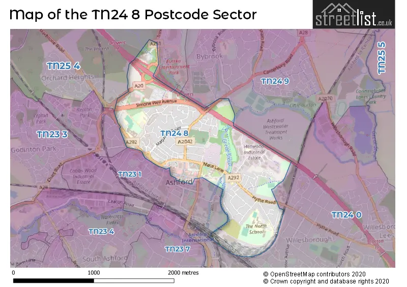
The TN24 8 Postcode shares a border with TN24 9 (Kennington), TN25 4 (ASHFORD, Challock, Kennington), TN23 1 (ASHFORD), TN23 3 (Kingsnorth, ASHFORD, Great Chart) and TN24 0 (Willesborough, ASHFORD, Sevington).
The sector is within the post town of ASHFORD.
TN24 8 is a postcode sector within the TN24 postcode district which is within the TN Tonbridge postcode area.
The Royal Mail delivery office for the TN24 8 postal sector is the Ashford (tn) Delivery Office.
The area of the TN24 8 postcode sector is 0.96 square miles which is 2.48 square kilometres or 612.99 square acres.
The TN24 8 postcode sector is crossed by the M20 motorway.
Waterways within the TN24 8 postcode sector include the Great Stour.

Map of the TN24 8 Postcode Sector
Explore the TN24 8 postcode sector by using our free interactive map.
| T | N | 2 | 4 | - | 8 | X | X |
| T | N | 2 | 4 | Space | 8 | Letter | Letter |
Official List of Streets
ASHFORD (76 Streets)
Henwood Industrial Estate (2 Streets)
Unofficial Streets or Alternative Spellings
ASHFORD
BANK STREET BARROW HILL CASTLE STREET COUNTY SQUARE FORGE LANE FOUGERES WAY GILBERT ROAD MIDDLE ROW REPTON MANOR ROAD TRINITY ROADBilting
CANTERBURY ROAD BARROWHILL PLACE CHAPEL MEWS COLEPAX PLACE DOWNLAND COURT DROVERS INTERCHANGE EDINBURGH ROAD ESSELLA PARK EUREKA SKYLINE BRIDGE GORE COURT GROVES BUSINESS PARK HAVENTHORPE HENWOOD PLACE HERON BUSINESS CENTRE HIGHPOINT BUSINESS PARK PILGRIMS CYCLE TRAIL SERVICE AREA D ST JOHNS LANE ST. JOHNS PASSAGE TAYLORS PASSAGE THE CHURCHYARD THOMSON ROADWillesborough
HYTHE ROADKennington
CEMETERY LANEGreat Chart
CHART ROADCharing
MAIDSTONE ROADWeather Forecast for TN24 8
Press Button to Show Forecast for Ashford
| Time Period | Icon | Description | Temperature | Rain Probability | Wind |
|---|---|---|---|---|---|
| 09:00 to 12:00 | Cloudy | 10.0°C (feels like 9.0°C) | 13.00% | ESE 7 mph | |
| 12:00 to 15:00 | Cloudy | 13.0°C (feels like 11.0°C) | 9.00% | ESE 7 mph | |
| 15:00 to 18:00 | Cloudy | 12.0°C (feels like 11.0°C) | 34.00% | E 9 mph | |
| 18:00 to 21:00 | Light rain | 11.0°C (feels like 9.0°C) | 57.00% | ENE 11 mph | |
| 21:00 to 00:00 | Heavy rain | 10.0°C (feels like 8.0°C) | 89.00% | ENE 9 mph |
Press Button to Show Forecast for Ashford
| Time Period | Icon | Description | Temperature | Rain Probability | Wind |
|---|---|---|---|---|---|
| 00:00 to 03:00 | Heavy rain | 11.0°C (feels like 9.0°C) | 86.00% | E 9 mph | |
| 03:00 to 06:00 | Heavy rain | 10.0°C (feels like 8.0°C) | 75.00% | SSE 11 mph | |
| 06:00 to 09:00 | Heavy rain | 10.0°C (feels like 7.0°C) | 77.00% | SSW 11 mph | |
| 09:00 to 12:00 | Light rain shower (day) | 10.0°C (feels like 7.0°C) | 42.00% | SSW 16 mph | |
| 12:00 to 15:00 | Light rain shower (day) | 11.0°C (feels like 8.0°C) | 40.00% | WSW 18 mph | |
| 15:00 to 18:00 | Cloudy | 11.0°C (feels like 8.0°C) | 16.00% | WSW 16 mph | |
| 18:00 to 21:00 | Partly cloudy (day) | 10.0°C (feels like 8.0°C) | 8.00% | WSW 11 mph | |
| 21:00 to 00:00 | Clear night | 8.0°C (feels like 6.0°C) | 4.00% | SW 9 mph |
Press Button to Show Forecast for Ashford
| Time Period | Icon | Description | Temperature | Rain Probability | Wind |
|---|---|---|---|---|---|
| 00:00 to 03:00 | Partly cloudy (night) | 7.0°C (feels like 5.0°C) | 3.00% | WSW 7 mph | |
| 03:00 to 06:00 | Clear night | 6.0°C (feels like 4.0°C) | 2.00% | SW 7 mph | |
| 06:00 to 09:00 | Sunny day | 9.0°C (feels like 7.0°C) | 1.00% | S 7 mph | |
| 09:00 to 12:00 | Partly cloudy (day) | 12.0°C (feels like 10.0°C) | 3.00% | S 9 mph | |
| 12:00 to 15:00 | Partly cloudy (day) | 13.0°C (feels like 11.0°C) | 3.00% | S 11 mph | |
| 15:00 to 18:00 | Sunny day | 13.0°C (feels like 12.0°C) | 2.00% | S 9 mph | |
| 18:00 to 21:00 | Sunny day | 12.0°C (feels like 11.0°C) | 3.00% | SSE 7 mph | |
| 21:00 to 00:00 | Cloudy | 10.0°C (feels like 8.0°C) | 6.00% | ESE 7 mph |
Press Button to Show Forecast for Ashford
| Time Period | Icon | Description | Temperature | Rain Probability | Wind |
|---|---|---|---|---|---|
| 00:00 to 03:00 | Partly cloudy (night) | 10.0°C (feels like 8.0°C) | 5.00% | ESE 9 mph | |
| 03:00 to 06:00 | Clear night | 9.0°C (feels like 7.0°C) | 6.00% | ESE 7 mph | |
| 06:00 to 09:00 | Cloudy | 10.0°C (feels like 9.0°C) | 9.00% | SE 7 mph | |
| 09:00 to 12:00 | Cloudy | 12.0°C (feels like 11.0°C) | 9.00% | SE 9 mph | |
| 12:00 to 15:00 | Cloudy | 14.0°C (feels like 12.0°C) | 11.00% | SE 9 mph | |
| 15:00 to 18:00 | Cloudy | 15.0°C (feels like 13.0°C) | 10.00% | SE 9 mph | |
| 18:00 to 21:00 | Cloudy | 13.0°C (feels like 12.0°C) | 16.00% | E 7 mph | |
| 21:00 to 00:00 | Overcast | 12.0°C (feels like 10.0°C) | 17.00% | E 7 mph |
Schools and Places of Education Within the TN24 8 Postcode Sector
Cornfields School
Other independent special school
207 Hythe Road, , , TN24 8PL
Head: Ms Alison Hatch
Ofsted Rating: Outstanding
Inspection: 2022-03-17 (772 days ago)
Website: Visit Cornfields School Website
Phone: 01233877046
Number of Pupils: 50
Highworth Grammar School
Academy converter
Maidstone Road, Ashford, Kent, TN24 8UD
Head: Mr Duncan Beer
Ofsted Rating: Outstanding
Inspection: 2013-06-14 (3970 days ago)
Website: Visit Highworth Grammar School Website
Phone: 01233624910
Number of Pupils: 1542
St Teresa's Catholic Primary School
Academy converter
Quantock Drive, Ashford, Kent, TN24 8QN
Head: Mrs H Bennett
Ofsted Rating: Good
Inspection: 2020-01-16 (1563 days ago)
Website: Visit St Teresa's Catholic Primary School Website
Phone: 01233622797
Number of Pupils: 213
House Prices in the TN24 8 Postcode Sector
| Type of Property | 2018 Average | 2018 Sales | 2017 Average | 2017 Sales | 2016 Average | 2016 Sales | 2015 Average | 2015 Sales |
|---|---|---|---|---|---|---|---|---|
| Detached | £365,662 | 10 | £375,706 | 17 | £385,900 | 20 | £340,390 | 25 |
| Semi-Detached | £281,840 | 47 | £294,896 | 39 | £248,307 | 44 | £223,190 | 29 |
| Terraced | £221,885 | 39 | £229,152 | 43 | £213,255 | 39 | £194,618 | 59 |
| Flats | £163,938 | 16 | £150,785 | 43 | £124,551 | 254 | £119,269 | 26 |
Important Postcodes TN24 8 in the Postcode Sector
TN24 8AD is the postcode for Kent County Council, 4 Javelin Way, Ashford Highway Depot, 4 Javelin Way, and ASHFORD HIGHWAY DEPOT, 4 JAVELIN WAY, ASHFORD
TN24 8AL is the postcode for C2 SPORTS HALL, The North School, Essella Road, LAND-BASED CENTRE, The North School, Essella Road, TB3 & C1, The North School, Essella Road, TB1, The North School, Essella Road, The North School, Essella Road, and TB4, The North School, Essella Road
TN24 8BJ is the postcode for Ashford North Youth Centre, Mabledon Avenue
TN24 8DN is the postcode for Sydenham House Medical Practice, Mill Court
TN24 8DR is the postcode for Ashford College, Henwood Industrial Estate
TN24 8EF is the postcode for H M Revenue & Customs, 34 Wellesley Road
TN24 8FL is the postcode for CHIME COMMUNICATIONS LIMITED, Watermelon Research, 3 Henwood
TN24 8QN is the postcode for St. Teresas School, Quantock Drive, ST TERESAS CATHOLIC PRIMARY SCHOOL, QUANTOCK DRIVE, ASHFORD, and St Teresas Catholic Primary School, Quantock Drive
TN24 8TB is the postcode for George Hotel, 68 High Street
TN24 8UD is the postcode for SPORTS HALL, Highworth Grammar School for Girls, Quantock Drive, Highworth Grammar School for Girls, Quantock Drive, and GOWER HOUSE, Highworth Grammar School for Girls, Quantock Drive
TN24 8XU is the postcode for Kroner House, The Eurogate Business Park, and Kent County Council, Kroner House, The Eurogate Business Park
TN24 8YF is the postcode for Kent Fire & Rescue Service, Fire Station, Henwood
| The TN24 8 Sector is within these Local Authorities |
|
|---|---|
| The TN24 8 Sector is within these Counties |
|
| The TN24 8 Sector is within these Water Company Areas |
|
Tourist Attractions within the TN24 8 Postcode Area
We found 1 visitor attractions within the TN24 postcode area
| Ashford Borough Museum |
|---|
| Museums & Art Galleries |
| Museum and / or Art Gallery |
| View Ashford Borough Museum on Google Maps |