The TW11 0 postcode sector is within the county of Greater London.
Did you know? According to the 2021 Census, the TW11 0 postcode sector is home to a bustling 6,987 residents!
Given that each sector allows for 400 unique postcode combinations. Letters C, I, K, M, O and V are not allowed in the last two letters of a postcode. With 166 postcodes already in use, this leaves 234 units available.
The TW11 0 postal code covers the settlement of TEDDINGTON .
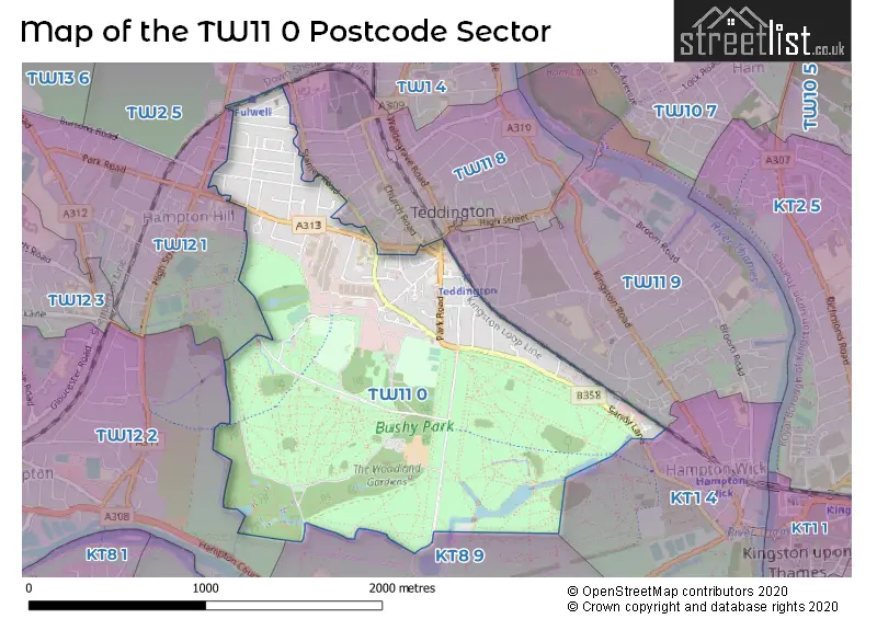
The TW11 0 Postcode shares a border with TW2 5 (TWICKENHAM ), TW11 8 (TEDDINGTON ), TW11 9 (TEDDINGTON ), TW12 2 (HAMPTON ), TW12 1 (HAMPTON HILL , HAMPTON ), KT1 4 (HAMPTON WICK , KINGSTON UPON THAMES ) and KT8 9 (EAST MOLESEY , HAMPTON ).
The sector is within the post town of TEDDINGTON.
TW11 0 is a postcode sector within the TW11 postcode district which is within the TW Twickenham postcode area.
The Royal Mail delivery office for the TW11 0 postal sector is the Teddington Delivery Office.
The area of the TW11 0 postcode sector is 1.31 square miles which is 3.39 square kilometres or 837.44 square acres.

Map of the TW11 0 Postcode Sector
Explore the TW11 0 postcode sector by using our free interactive map.
| T | W | 1 | 1 | - | 0 | X | X |
| T | W | 1 | 1 | Space | 0 | Letter | Letter |
Official List of Streets
TEDDINGTON (59 Streets)
Unofficial Streets or Alternative Spellings
TEDDINGTON
ALLBROOK CLOSE BROAD STREET CHURCH ROAD SOMERSET ROAD STABLEYARD MEWSKINGSTON UPON THAMES,
SANDY LANE BULLARD ROAD BUSHY ROAD CAPITAL JOINERY CHESTNUT AVENUE COBBLERS WALK COLESHILL PASSAGE CROCODILE BRIDGE DARWIN ROAD DUCK BRIDGE EAST ACCESS ROAD ELIZABETH COURT ESSEN WAY GLAZEBROOK ROAD NEW KELVIN AVENUE PETAVEL ROAD RAYLEIGH AVENUE RED BRICK BRIDGE TEDDINGTON HALL TESCO DELIVERY THE CEDARS TUDOR COURT TURING ROAD WELLINGTON COURT WEST ACCESS ROAD WIDTEWING CLOSEHampton Hill
HAMPTON ROAD LAUREL ROADHAMPTON,
WELLINGTON ROADTEDDINGTON,
STANLEY ROADWeather Forecast for TW11 0
Press Button to Show Forecast for Hampton Court Palace
| Time Period | Icon | Description | Temperature | Rain Probability | Wind |
|---|---|---|---|---|---|
| 06:00 to 09:00 | Cloudy | 6.0°C (feels like 3.0°C) | 5.00% | NE 7 mph | |
| 09:00 to 12:00 | Cloudy | 8.0°C (feels like 6.0°C) | 6.00% | ENE 9 mph | |
| 12:00 to 15:00 | Cloudy | 11.0°C (feels like 9.0°C) | 9.00% | ENE 7 mph | |
| 15:00 to 18:00 | Overcast | 11.0°C (feels like 10.0°C) | 16.00% | ENE 7 mph | |
| 18:00 to 21:00 | Cloudy | 11.0°C (feels like 9.0°C) | 13.00% | NE 7 mph | |
| 21:00 to 00:00 | Cloudy | 8.0°C (feels like 6.0°C) | 13.00% | E 7 mph |
Press Button to Show Forecast for Hampton Court Palace
| Time Period | Icon | Description | Temperature | Rain Probability | Wind |
|---|---|---|---|---|---|
| 00:00 to 03:00 | Cloudy | 6.0°C (feels like 4.0°C) | 16.00% | ENE 7 mph | |
| 03:00 to 06:00 | Light rain | 5.0°C (feels like 3.0°C) | 47.00% | NE 7 mph | |
| 06:00 to 09:00 | Cloudy | 6.0°C (feels like 4.0°C) | 18.00% | NE 7 mph | |
| 09:00 to 12:00 | Cloudy | 10.0°C (feels like 8.0°C) | 16.00% | ENE 9 mph | |
| 12:00 to 15:00 | Overcast | 12.0°C (feels like 10.0°C) | 17.00% | E 9 mph | |
| 15:00 to 18:00 | Cloudy | 13.0°C (feels like 10.0°C) | 23.00% | E 11 mph | |
| 18:00 to 21:00 | Light rain | 11.0°C (feels like 9.0°C) | 53.00% | ENE 9 mph | |
| 21:00 to 00:00 | Light rain | 10.0°C (feels like 8.0°C) | 52.00% | NE 11 mph |
Press Button to Show Forecast for Hampton Court Palace
| Time Period | Icon | Description | Temperature | Rain Probability | Wind |
|---|---|---|---|---|---|
| 00:00 to 03:00 | Heavy rain | 10.0°C (feels like 7.0°C) | 70.00% | NE 9 mph | |
| 03:00 to 06:00 | Heavy rain shower (night) | 10.0°C (feels like 8.0°C) | 61.00% | ESE 9 mph | |
| 06:00 to 09:00 | Light rain | 10.0°C (feels like 8.0°C) | 52.00% | ESE 7 mph | |
| 09:00 to 12:00 | Heavy rain | 11.0°C (feels like 9.0°C) | 75.00% | ESE 9 mph | |
| 12:00 to 15:00 | Heavy rain shower (day) | 12.0°C (feels like 11.0°C) | 62.00% | SSE 9 mph | |
| 15:00 to 18:00 | Light rain shower (day) | 14.0°C (feels like 12.0°C) | 40.00% | SW 11 mph | |
| 18:00 to 21:00 | Light rain shower (day) | 12.0°C (feels like 10.0°C) | 35.00% | WSW 11 mph | |
| 21:00 to 00:00 | Partly cloudy (night) | 10.0°C (feels like 9.0°C) | 10.00% | WSW 7 mph |
House Prices in the TW11 0 Postcode Sector
| Type of Property | 2018 Average | 2018 Sales | 2017 Average | 2017 Sales | 2016 Average | 2016 Sales | 2015 Average | 2015 Sales |
|---|---|---|---|---|---|---|---|---|
| Detached | £1,302,750 | 4 | £1,634,158 | 6 | £1,700,000 | 9 | £1,070,500 | 7 |
| Semi-Detached | £1,091,095 | 26 | £1,018,810 | 21 | £1,062,096 | 24 | £1,008,208 | 19 |
| Terraced | £763,555 | 29 | £811,949 | 37 | £771,423 | 28 | £770,187 | 34 |
| Flats | £401,463 | 65 | £427,810 | 58 | £408,010 | 57 | £402,864 | 55 |
Important Postcodes TW11 0 in the Postcode Sector
TW11 0AQ is the postcode for Teddington Police Station, 18 Park Road, 18, Park Road, and Metropolitan Police, Teddington Police Station, 18 Park Road
TW11 0JL is the postcode for TEDDINGTON WAR MEMORIAL HOSPITAL, HAMPTON ROAD, TEDDINGTON, Teddington Memorial Hospital, Hampton Road, TEDDINGTON HEALTH & SOCIAL CARE CENTRE TEDDINGTON MEMORIAL HOSPITAL, Teddington Memorial Hospital, Hampton Road, TEDDINGTON HEALTH & SOCIAL CARE CENTRE, Teddington Memorial Hospital, Hampton Road, and Richmond And Twickenham PCT, Teddington Memorial Hospital
TW11 0JZ is the postcode for National Measurement and Regulation Office, Stanton Avenue, and Office for Product Safety & Standards, Stanton Avenue, Teddington
TW11 0LR is the postcode for Turing House School, 2 Queens Road
TW11 0LW is the postcode for National Physical Laboratory, Hampton Road, BUILDING 51, National Physical Laboratory, Hampton Road, and BUSHY HOUSE, National Physical Laboratory, Hampton Road
| The TW11 0 Sector is within these Local Authorities |
|
|---|---|
| The TW11 0 Sector is within these Counties |
|
| The TW11 0 Sector is within these Water Company Areas |
|