The W2 1 postcode sector is within the county of Greater London.
Did you know? According to the 2021 Census, the W2 1 postcode sector is home to a bustling 7,628 residents!
Given that each sector allows for 400 unique postcode combinations. Letters C, I, K, M, O and V are not allowed in the last two letters of a postcode. With 213 postcodes already in use, this leaves 187 units available.
The largest settlements in the W2 1 postal code are LONDON and CITY OF WESTMINSTER .
The W2 1 Postcode shares a border with NW1 5 (LONDON , BRYANSTON ), NW8 8 (LONDON ), W2 2 (LONDON ), W2 3 (LONDON , BAYSWATER ), W2 6 (LONDON ), W9 2 (LONDON ), NW1 6 (LONDON ) and W9 1 (LONDON ).
The sector is within the post town of LONDON.
W2 1 is a postcode sector within the W2 postcode district which is within the W West London postcode area.
The Royal Mail delivery office for the W2 1 postal sector is the Paddington Sdelivery Office.
The area of the W2 1 postcode sector is 0.23 square miles which is 0.59 square kilometres or 146.27 square acres.
Waterways within the W2 1 postcode sector include the Paddington Basin, Regent's Canal.

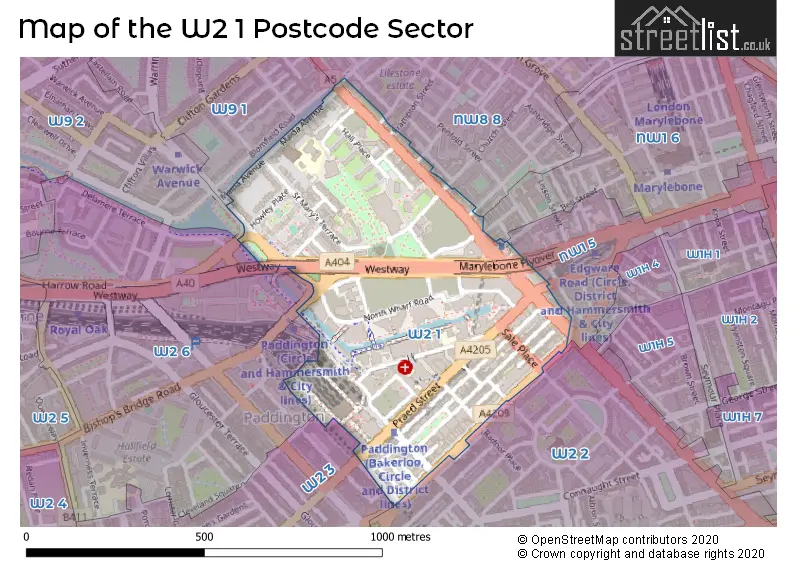
Map of the W2 1 Postcode Sector
Explore the W2 1 postcode sector by using our free interactive map.
| W | 2 | - | 1 | X | X |
| W | 2 | Space | 1 | Letter | Letter |
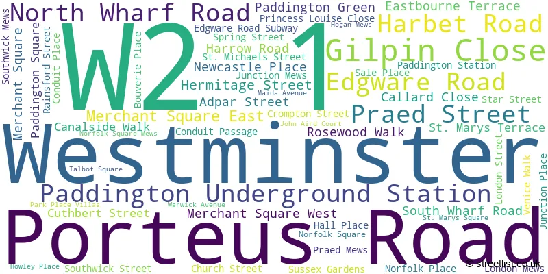
Official List of Streets
Westminster (55 Streets)
Unofficial Streets or Alternative Spellings
Camden
MAIDA VALE MARYLEBONE ROADWestminster
ABERDEEN PLACE BELL STREET BOSCOBEL STREET BROADLEY STREET CHAPEL STREET CONDUIT MEWS FRAMPTON STREET NORFOLK CRESCENT ORCHARDSON STREET PENFOLD PLACE RADNOR PLACE ROSEWOOD WALK BISHOPS BRIDGE ROAD CANAL WALK CHURCH YARD WALK DUDLEY STREET GRAND UNION CANAL (PADDINGTON ARM) TOWPATH HOWARDS WAY JOE STRUMMER SUBWAY MARYLEBONE FLYOVER PORTEUS ROAD UNDERPASS SAINT MARYS SQUARE SAINT MICHAELS STREET ST MARYS MANSIONS TANNER LANE THE FAN BRIDGE THE ROLLING BRIDGE WINSLAND MEWS WINSLAND STREETBrent
HARROW ROADHammersmith and Fulham
WESTWAYWeather Forecast for W2 1
Press Button to Show Forecast for Lord's Marylebone C.C.
| Time Period | Icon | Description | Temperature | Rain Probability | Wind |
|---|---|---|---|---|---|
| 06:00 to 09:00 | Cloudy | 5.0°C (feels like 3.0°C) | 4.00% | NE 7 mph | |
| 09:00 to 12:00 | Cloudy | 8.0°C (feels like 6.0°C) | 4.00% | ENE 7 mph | |
| 12:00 to 15:00 | Cloudy | 10.0°C (feels like 9.0°C) | 10.00% | ENE 7 mph | |
| 15:00 to 18:00 | Cloudy | 11.0°C (feels like 10.0°C) | 13.00% | ENE 7 mph | |
| 18:00 to 21:00 | Cloudy | 10.0°C (feels like 9.0°C) | 13.00% | NE 7 mph | |
| 21:00 to 00:00 | Cloudy | 7.0°C (feels like 5.0°C) | 11.00% | E 7 mph |
Press Button to Show Forecast for Lord's Marylebone C.C.
| Time Period | Icon | Description | Temperature | Rain Probability | Wind |
|---|---|---|---|---|---|
| 00:00 to 03:00 | Cloudy | 6.0°C (feels like 4.0°C) | 17.00% | ENE 7 mph | |
| 03:00 to 06:00 | Cloudy | 5.0°C (feels like 3.0°C) | 18.00% | NE 7 mph | |
| 06:00 to 09:00 | Overcast | 6.0°C (feels like 3.0°C) | 24.00% | ENE 7 mph | |
| 09:00 to 12:00 | Cloudy | 9.0°C (feels like 7.0°C) | 15.00% | ENE 9 mph | |
| 12:00 to 15:00 | Overcast | 12.0°C (feels like 10.0°C) | 17.00% | E 9 mph | |
| 15:00 to 18:00 | Light rain | 12.0°C (feels like 10.0°C) | 52.00% | E 11 mph | |
| 18:00 to 21:00 | Light rain | 11.0°C (feels like 9.0°C) | 54.00% | ENE 9 mph | |
| 21:00 to 00:00 | Light rain | 10.0°C (feels like 7.0°C) | 54.00% | NE 11 mph |
Press Button to Show Forecast for Lord's Marylebone C.C.
| Time Period | Icon | Description | Temperature | Rain Probability | Wind |
|---|---|---|---|---|---|
| 00:00 to 03:00 | Heavy rain | 9.0°C (feels like 7.0°C) | 74.00% | NE 9 mph | |
| 03:00 to 06:00 | Light rain shower (night) | 10.0°C (feels like 8.0°C) | 45.00% | ESE 9 mph | |
| 06:00 to 09:00 | Light rain | 10.0°C (feels like 8.0°C) | 52.00% | SE 7 mph | |
| 09:00 to 12:00 | Heavy rain shower (day) | 11.0°C (feels like 9.0°C) | 61.00% | SE 9 mph | |
| 12:00 to 15:00 | Heavy rain shower (day) | 12.0°C (feels like 10.0°C) | 61.00% | S 9 mph | |
| 15:00 to 18:00 | Light rain shower (day) | 14.0°C (feels like 12.0°C) | 37.00% | SSW 11 mph | |
| 18:00 to 21:00 | Partly cloudy (day) | 12.0°C (feels like 10.0°C) | 15.00% | SW 11 mph | |
| 21:00 to 00:00 | Partly cloudy (night) | 10.0°C (feels like 9.0°C) | 8.00% | SW 7 mph |
Schools and Places of Education Within the W2 1 Postcode Sector
Marylebone Boys' School
Free schools
North Wharf Road, London, , W2 1QZ
Head: Mr Richard Ardron
Ofsted Rating: Good
Inspection: 2022-11-16 (527 days ago)
Website: Visit Marylebone Boys' School Website
Phone: 02031437100
Number of Pupils: 727
United Colleges Group
Further education
25 Paddington Green, London, , W2 1NB
Head: Mr Stephen Davis
Ofsted Rating: Requires improvement
Inspection: 2022-11-25 (518 days ago)
Website: Visit United Colleges Group Website
Phone: 02077238826
Number of Pupils: 0
House Prices in the W2 1 Postcode Sector
| Type of Property | 2018 Average | 2018 Sales | 2017 Average | 2017 Sales | 2016 Average | 2016 Sales | 2015 Average | 2015 Sales |
|---|---|---|---|---|---|---|---|---|
| Detached | £6,500,000 | 1 | £0 | 0 | £7,000,000 | 1 | £0 | 0 |
| Semi-Detached | £5,250,000 | 1 | £0 | 0 | £0 | 0 | £7,250,000 | 1 |
| Terraced | £2,508,750 | 4 | £2,456,667 | 6 | £2,205,000 | 6 | £678,000 | 1 |
| Flats | £956,805 | 62 | £1,139,445 | 101 | £1,217,104 | 143 | £1,232,993 | 102 |
Important Postcodes W2 1 in the Postcode Sector
W2 1JX is the postcode for Post Office, 4a Praed Street
W2 1LF is the postcode for Paddington Basin Campus, North Wharf Road
W2 1LQ is the postcode for Paddington Green Health Centre, 4 Princess Louise Close
W2 1NB is the postcode for City of Westminster College, Paddington Centre, and City of Westminster College, Paddington Centre, 25 Paddington Green
W2 1ND is the postcode for Little Venice Sports Centre, 10 Crompton Street, and King Solomon Academy Younger Years Site, Crompton Street
W2 1NY is the postcode for JEFFERISS WING, Imperial College Healthcare NHS Trust, St Mary's Hospital, CLARENCE WING, Imperial College Healthcare NHS Trust, St Mary's Hospital, WEST ACROW, Imperial College Healthcare NHS Trust, St Mary's Hospital, LINDO WING & MRI, Imperial College Healthcare NHS Trust, St Mary's Hospital, EAST ACROW, Imperial College Healthcare NHS Trust, St Mary's Hospital, PATERSON CENTRE, Imperial College Healthcare NHS Trust, St Mary's Hospital, SALTON HOUSE, Imperial College Healthcare NHS Trust, St Mary's Hospital, Imperial College Healthcare NHS Trust, St Mary's Hospital, WINSTON CHURCHILL BUILDING, Imperial College Healthcare NHS Trust, St Mary's Hospital, MARY STANFORD WING, Imperial College Healthcare NHS Trust, St Mary's Hospital, OUTPATIENTS DEPARTMENT, Imperial College Healthcare NHS Trust, St Mary's Hospital, VICTORIA & ALBERT AND DUMBELL BUILDINGS, Imperial College Healthcare NHS Trust, St Mary's Hospital, MINT WING, Imperial College Healthcare NHS Trust, St Mary's Hospital, QEQM + A&E, Imperial College Healthcare NHS Trust, St Mary's Hospital, and CAMBRIDGE WING, Imperial College Healthcare NHS Trust, St Mary's Hospital
W2 1PG is the postcode for St. Marys Hospital Medical School, Norfolk Place
W2 1SP is the postcode for Ark Paddington Green Academy, Park Place Villas
W2 1SU is the postcode for Community Day Services, 1 St. Marys Terrace
W2 1TT is the postcode for LILLIAN PENSON HALL, 15-25 TALBOT SQUARE, LONDON, Lillian Penson Hall University of London, Talbot Square, and Lillian Penson Hall, University Of London, Talbot Square
W2 1UF is the postcode for Imperial College London, Wilson House, 38-76 Sussex Gardens
W2 1XJ is the postcode for Metropolitan Police, Paddington Green Police Station, 4 Harrow Road
| The W2 1 Sector is within these Local Authorities |
|
|---|---|
| The W2 1 Sector is within these Counties |
|
| The W2 1 Sector is within these Water Company Areas |
|