The WA4 6 postcode sector is within the county of Cheshire.
Did you know? According to the 2021 Census, the WA4 6 postcode sector is home to a bustling 9,511 residents!
Given that each sector allows for 400 unique postcode combinations. Letters C, I, K, M, O and V are not allowed in the last two letters of a postcode. With 289 postcodes already in use, this leaves 111 units available.
The largest settlement in the WA4 6 postal code is WARRINGTON followed by Stockton Heath, and Moore.
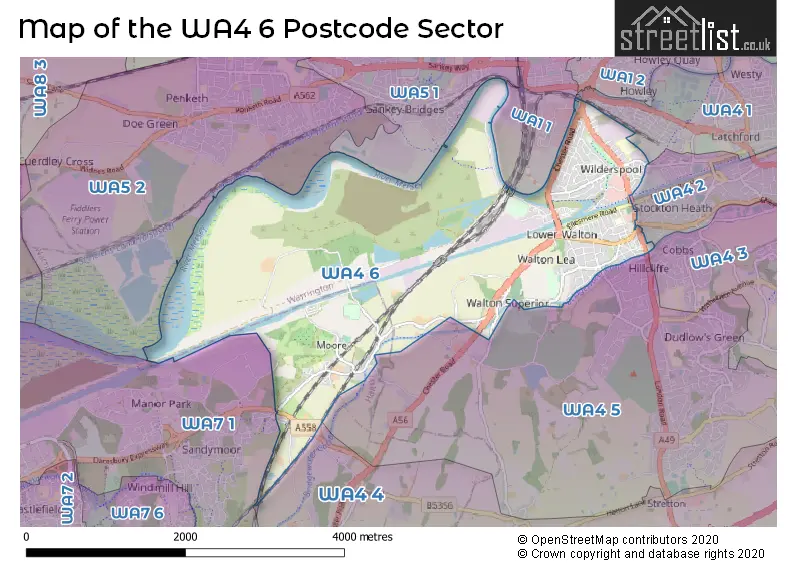
The WA4 6 Postcode shares a border with WA7 1 (RUNCORN, Astmoor Industrial Estate, Manor Park), WA1 1 (WARRINGTON), WA4 1 (WARRINGTON, Latchford), WA4 2 (Grappenhall, Stockton Heath, Thelwall), WA4 3 (Appleton, Grappenhall, WARRINGTON), WA4 4 (Appleton Thorn, Daresbury, Dutton), WA4 5 (Appleton, Hatton, Higher Walton), WA5 1 (Great Sankey, WARRINGTON) and WA5 2 (Penketh, Great Sankey, Cuerdley).
The sector is within the post town of WARRINGTON.
WA4 6 is a postcode sector within the WA4 postcode district which is within the WA Warrington postcode area.
The Royal Mail delivery office for the WA4 6 postal sector is the Warrington Delivery Office.
The area of the WA4 6 postcode sector is 5.22 square miles which is 13.52 square kilometres or 3,341.06 square acres.
Waterways within the WA4 6 postcode sector include the Sankey Brook, Manchester Ship Canal, River Mersey, Chester Road underbridge, Bridgewater Canal.

Map of the WA4 6 Postcode Sector
Explore the WA4 6 postcode sector by using our free interactive map.
| W | A | 4 | - | 6 | X | X |
| W | A | 4 | Space | 6 | Letter | Letter |
Official List of Streets
WARRINGTON (65 Streets)
Stockton Heath (38 Streets)
Moore (12 Streets)
Higher Walton (10 Streets)
Walton (19 Streets)
Daresbury (3 Streets)
Unofficial Streets or Alternative Spellings
WARRINGTON
SLUTCHERS LANE ACTON GRANGE TUNNEL BACK EASTFORD ROAD BARONET MEWS BLACK BEAR PARK BRIAN BEVAN ISLAND BRIDGEWATER MEWS CENTRAL AVENUE CHESTER NEW ROAD CHESTER ROAD SERVICE STATION CHESTER ROAD UNDERBRIDGE CONIFER GROVE DARESBURY EXPRESSWAY EASTGATE ROAD GREENBANK STREET HOLLY HEDGE LANE HOUGHS LANE KINGS MEWS MEADOW AVENUE MID MERSEY CYCLE PATH - CHESTER ROAD PARK BOULEVARD POPLAR VIEW RED LANE FOOTBRIDGE ST. AMBROSE COURT STOCKTON VIEW THE FORGE THE VILLAGE TERRACE TRANS PENNINE TRAIL WALTON NEW ROAD WEDGEWOOD DRIVE WESTERN LINK WILLOW CRESCENTStockton Heath
EAST AVENUE FAIRFIELD ROAD GRAPPENHALL ROAD SANDY LANEAppleton
LONDON ROAD RED LANEMoore
CANAL SIDERUNCORN
PARTINGTON SQUARE STALBRIDGE DRIVEManor Park
BLACKHEATH LANEDaresbury
CHESTER ROAD HOBB LANEHatton
WARRINGTON ROADWeather Forecast for WA4 6
Press Button to Show Forecast for Walton Hall Gardens
| Time Period | Icon | Description | Temperature | Rain Probability | Wind |
|---|---|---|---|---|---|
| 00:00 to 03:00 | Cloudy | 6.0°C (feels like 4.0°C) | 6.00% | ENE 7 mph | |
| 03:00 to 06:00 | Cloudy | 5.0°C (feels like 3.0°C) | 8.00% | ENE 7 mph | |
| 06:00 to 09:00 | Cloudy | 5.0°C (feels like 2.0°C) | 5.00% | ENE 7 mph | |
| 09:00 to 12:00 | Cloudy | 8.0°C (feels like 5.0°C) | 5.00% | ENE 9 mph | |
| 12:00 to 15:00 | Overcast | 9.0°C (feels like 7.0°C) | 13.00% | ENE 9 mph | |
| 15:00 to 18:00 | Cloudy | 9.0°C (feels like 7.0°C) | 12.00% | ENE 9 mph | |
| 18:00 to 21:00 | Cloudy | 9.0°C (feels like 7.0°C) | 14.00% | ENE 9 mph | |
| 21:00 to 00:00 | Cloudy | 8.0°C (feels like 5.0°C) | 5.00% | NE 7 mph |
Press Button to Show Forecast for Walton Hall Gardens
| Time Period | Icon | Description | Temperature | Rain Probability | Wind |
|---|---|---|---|---|---|
| 00:00 to 03:00 | Cloudy | 6.0°C (feels like 4.0°C) | 4.00% | NNE 7 mph | |
| 03:00 to 06:00 | Cloudy | 6.0°C (feels like 3.0°C) | 6.00% | N 9 mph | |
| 06:00 to 09:00 | Cloudy | 6.0°C (feels like 3.0°C) | 10.00% | N 9 mph | |
| 09:00 to 12:00 | Cloudy | 7.0°C (feels like 5.0°C) | 12.00% | NNW 9 mph | |
| 12:00 to 15:00 | Cloudy | 9.0°C (feels like 7.0°C) | 13.00% | NW 9 mph | |
| 15:00 to 18:00 | Cloudy | 10.0°C (feels like 8.0°C) | 11.00% | WNW 11 mph | |
| 18:00 to 21:00 | Sunny day | 10.0°C (feels like 8.0°C) | 4.00% | W 9 mph | |
| 21:00 to 00:00 | Clear night | 8.0°C (feels like 6.0°C) | 1.00% | SW 7 mph |
Press Button to Show Forecast for Walton Hall Gardens
| Time Period | Icon | Description | Temperature | Rain Probability | Wind |
|---|---|---|---|---|---|
| 00:00 to 03:00 | Partly cloudy (night) | 6.0°C (feels like 4.0°C) | 1.00% | S 7 mph | |
| 03:00 to 06:00 | Clear night | 5.0°C (feels like 2.0°C) | 1.00% | S 9 mph | |
| 06:00 to 09:00 | Partly cloudy (day) | 6.0°C (feels like 3.0°C) | 2.00% | SSE 9 mph | |
| 09:00 to 12:00 | Partly cloudy (day) | 10.0°C (feels like 8.0°C) | 1.00% | S 13 mph | |
| 12:00 to 15:00 | Cloudy | 13.0°C (feels like 10.0°C) | 7.00% | S 16 mph | |
| 15:00 to 18:00 | Cloudy | 14.0°C (feels like 11.0°C) | 8.00% | S 13 mph | |
| 18:00 to 21:00 | Partly cloudy (day) | 13.0°C (feels like 11.0°C) | 5.00% | SSE 11 mph | |
| 21:00 to 00:00 | Clear night | 11.0°C (feels like 8.0°C) | 3.00% | SSE 11 mph |
Press Button to Show Forecast for Walton Hall Gardens
| Time Period | Icon | Description | Temperature | Rain Probability | Wind |
|---|---|---|---|---|---|
| 00:00 to 03:00 | Partly cloudy (night) | 9.0°C (feels like 7.0°C) | 4.00% | SE 11 mph | |
| 03:00 to 06:00 | Partly cloudy (night) | 9.0°C (feels like 6.0°C) | 3.00% | SE 11 mph | |
| 06:00 to 09:00 | Partly cloudy (day) | 9.0°C (feels like 6.0°C) | 2.00% | ESE 11 mph | |
| 09:00 to 12:00 | Partly cloudy (day) | 13.0°C (feels like 10.0°C) | 4.00% | ESE 13 mph | |
| 12:00 to 15:00 | Partly cloudy (day) | 15.0°C (feels like 12.0°C) | 7.00% | SE 13 mph | |
| 15:00 to 18:00 | Cloudy | 16.0°C (feels like 13.0°C) | 31.00% | SE 11 mph | |
| 18:00 to 21:00 | Light rain shower (day) | 15.0°C (feels like 13.0°C) | 29.00% | ESE 9 mph | |
| 21:00 to 00:00 | Partly cloudy (night) | 13.0°C (feels like 11.0°C) | 5.00% | ESE 9 mph |
Schools and Places of Education Within the WA4 6 Postcode Sector
Moore Primary School
Community school
Lindfield Close, Warrington, Cheshire, WA4 6UG
Head: Mrs Eileen Smith
Ofsted Rating: Good
Inspection: 2023-02-08 (444 days ago)
Website: Visit Moore Primary School Website
Phone: 01925740326
Number of Pupils: 206
Priestley College
Academy 16-19 converter
Loushers Lane, Warrington, Cheshire, WA4 6RD
Head: Mr James Gresty
Ofsted Rating: Good
Inspection: 2023-11-24 (155 days ago)
Website: Visit Priestley College Website
Phone: 01925633591
Number of Pupils: 0
Stockton Heath Primary School
Community school
West Avenue, Warrington, Cheshire, WA4 6HX
Head: Mr Dan Harding
Ofsted Rating: Good
Inspection: 2019-01-22 (1922 days ago)
Website: Visit Stockton Heath Primary School Website
Phone: 01925215640
Number of Pupils: 402
House Prices in the WA4 6 Postcode Sector
| Type of Property | 2018 Average | 2018 Sales | 2017 Average | 2017 Sales | 2016 Average | 2016 Sales | 2015 Average | 2015 Sales |
|---|---|---|---|---|---|---|---|---|
| Detached | £356,689 | 19 | £358,213 | 29 | £460,638 | 31 | £389,450 | 35 |
| Semi-Detached | £247,431 | 59 | £227,822 | 88 | £230,393 | 80 | £217,246 | 90 |
| Terraced | £232,506 | 58 | £208,638 | 63 | £219,168 | 84 | £194,077 | 82 |
| Flats | £134,978 | 30 | £134,255 | 32 | £141,673 | 60 | £135,551 | 62 |
Important Postcodes WA4 6 in the Postcode Sector
WA4 6BB is the postcode for St Werburgh's, Irwell Road
WA4 6HJ is the postcode for Stockton Heath Medical Centre, The Forge, London Road
WA4 6HX is the postcode for Stockton Heath Community Primary School, West Avenue, Stockton Heath, and Stockton Heath Community Primary School, West Avenue
WA4 6QR is the postcode for PERSONAL DEVELOPMENT CENTRE, Warrington Borough Council, Irwell Road
WA4 6RD is the postcode for CRESCENT BUILDING, Priestley College, Loushers Lane, ADAMSON CENTRE, Priestley College, Loushers Lane, LEWIS CARROLL CENTRE, Priestley College, Loushers Lane, PRIESTLEY BUILDING, Priestley College, Loushers Lane, LEARNING RESOURCE CENTRE, Priestley College, Loushers Lane, DESIGN CENTRE, Priestley College, Loushers Lane, SPORTS CENTRE, Priestley College, Loushers Lane, and ARTS CENTRE, Priestley College, Loushers Lane
WA4 6SN is the postcode for Walton Hall, Walton Lea Road
WA4 6TB is the postcode for Warrington Borough Council, Walton Lea Crematorium, Chester Road
WA4 6UG is the postcode for Moore Cp School, Lindfield Close, and Moore Cp School, Lindfield Close, Moore
| The WA4 6 Sector is within these Local Authorities |
|
|---|---|
| The WA4 6 Sector is within these Counties |
|
| The WA4 6 Sector is within these Water Company Areas |
|