The WC2H 0 postcode sector is within the county of Greater London.
Did you know? According to the 2021 Census, the WC2H 0 postcode sector is home to a bustling 483 residents!
Given that each sector allows for 400 unique postcode combinations. Letters C, I, K, M, O and V are not allowed in the last two letters of a postcode. With 55 postcodes already in use, this leaves 345 units available.
The WC2H 0 postal code covers the settlement of LONDON .
The WC2H 0 Postcode shares a border with W1D 2 (LONDON ), W1D 3 (LONDON ), W1D 4 (LONDON ), W1D 5 (LONDON ), WC1A 1 (LONDON ), WC2H 7 (LONDON ), WC2H 8 (LONDON ), WC2H 9 (LONDON ), WC2N 4 (LONDON ) and WC2N 5 (LONDON ).
The sector is within the post town of LONDON.
WC2H 0 is a postcode sector within the WC2H postcode district which is within the WC West Central London postcode area.
The Royal Mail delivery office for the WC2H 0 postal sector is the unknown.
The area of the WC2H 0 postcode sector is 0.02 square miles which is 0.04 square kilometres or 9.86 square acres.

Map of the WC2H 0 Postcode Sector
Explore the WC2H 0 postcode sector by using our free interactive map.
| W | C | 2 | H | - | 0 | X | X |
| W | C | 2 | H | Space | 0 | Letter | Letter |
Official List of Streets
Camden (1 Streets)
Westminster (2 Streets)
Unofficial Streets or Alternative Spellings
Camden
DENMARK STREET FLITCROFT STREET PHOENIX STREET SHAFTESBURY AVENUEWestminster
BEAR STREET CECIL COURT CRANBOURN ALLEY CRANBOURN STREET GREAT NEWPORT STREET IRVING STREET LITCHFIELD STREET LITTLE NEWPORT STREET MANETTE STREET MOOR STREET NEWPORT COURT OLD COMPTON STREET ORANGE STREET DENMARK PLACE GOSLETT YARD HUNTS COURT SAINT MARTINS COURT SOHO PLACE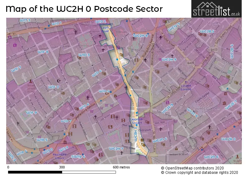
House Prices in the WC2H 0 Postcode Sector
| Type of Property | 2018 Average | 2018 Sales | 2017 Average | 2017 Sales | 2016 Average | 2016 Sales | 2015 Average | 2015 Sales |
|---|---|---|---|---|---|---|---|---|
| Detached | £0 | 0 | £0 | 0 | £0 | 0 | £0 | 0 |
| Semi-Detached | £0 | 0 | £0 | 0 | £0 | 0 | £0 | 0 |
| Terraced | £0 | 0 | £0 | 0 | £0 | 0 | £0 | 0 |
| Flats | £387,500 | 2 | £649,750 | 2 | £2,246,750 | 2 | £2,270,833 | 3 |
Important Postcodes WC2H 0 in the Postcode Sector
WC2H 0DA is the postcode for Wyndhams Theatre, Charing Cross Road
WC2H 0DU is the postcode for Central St. Martins College of Art & Design, 107-109 Charing Cross Road, and 111 Charing Cross Road
WC2H 0HF is the postcode for Charing Cross Library, 4-6 Charing Cross Road
| The WC2H 0 Sector is within these Local Authorities |
|
|---|---|
| The WC2H 0 Sector is within these Counties |
|
| The WC2H 0 Sector is within these Water Company Areas |
|