The WS7 2 postcode sector is within the county of Staffordshire.
Did you know? According to the 2021 Census, the WS7 2 postcode sector is home to a bustling 5,112 residents!
Given that each sector allows for 400 unique postcode combinations. Letters C, I, K, M, O and V are not allowed in the last two letters of a postcode. With 110 postcodes already in use, this leaves 290 units available.
The largest settlements in the WS7 2 postal code are BURNTWOOD and Chase Terrace.
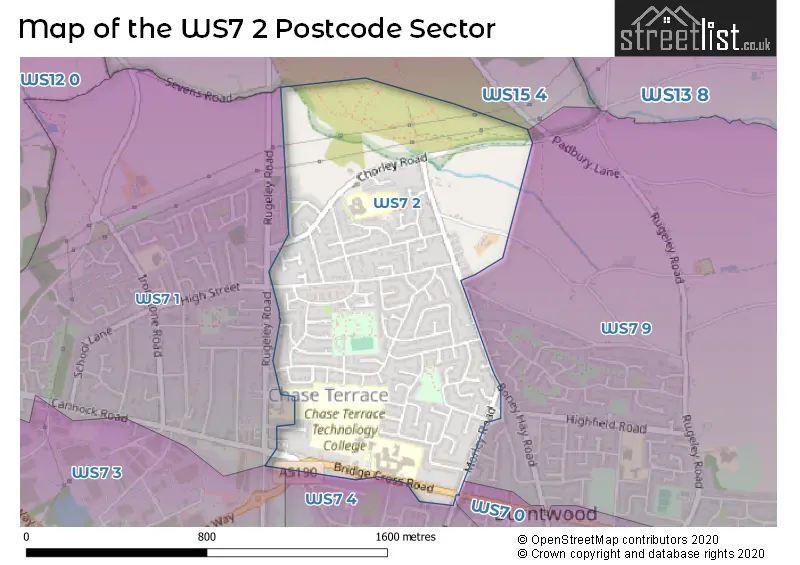
The WS7 2 Postcode shares a border with WS7 0 (BURNTWOOD, Hammerwich), WS7 1 (BURNTWOOD, Chase Terrace), WS7 4 (BURNTWOOD, Chasetown), WS15 4 (RUGELEY, Armitage, Handsacre), WS7 3 (BURNTWOOD, Chasetown, Burntwood Business Park) and WS7 9 (BURNTWOOD).
The sector is within the post town of BURNTWOOD.
WS7 2 is a postcode sector within the WS7 postcode district which is within the WS Walsall postcode area.
The Royal Mail delivery office for the WS7 2 postal sector is the Lichfield Delivery Office.
The area of the WS7 2 postcode sector is 0.64 square miles which is 1.65 square kilometres or 408.05 square acres.

Map of the WS7 2 Postcode Sector
Explore the WS7 2 postcode sector by using our free interactive map.
| W | S | 7 | - | 2 | X | X |
| W | S | 7 | Space | 2 | Letter | Letter |
Official List of Streets
BURNTWOOD (77 Streets)
Unofficial Streets or Alternative Spellings
Weather Forecast for WS7 2
Press Button to Show Forecast for Brownhills
| Time Period | Icon | Description | Temperature | Rain Probability | Wind |
|---|---|---|---|---|---|
| 06:00 to 09:00 | Cloudy | 4.0°C (feels like 1.0°C) | 10.00% | ENE 9 mph | |
| 09:00 to 12:00 | Cloudy | 7.0°C (feels like 4.0°C) | 21.00% | ENE 11 mph | |
| 12:00 to 15:00 | Light rain | 8.0°C (feels like 5.0°C) | 48.00% | ENE 11 mph | |
| 15:00 to 18:00 | Overcast | 8.0°C (feels like 5.0°C) | 19.00% | ENE 11 mph | |
| 18:00 to 21:00 | Overcast | 8.0°C (feels like 5.0°C) | 17.00% | ENE 11 mph | |
| 21:00 to 00:00 | Cloudy | 6.0°C (feels like 3.0°C) | 9.00% | NE 11 mph |
Press Button to Show Forecast for Brownhills
| Time Period | Icon | Description | Temperature | Rain Probability | Wind |
|---|---|---|---|---|---|
| 00:00 to 03:00 | Cloudy | 5.0°C (feels like 2.0°C) | 19.00% | NE 11 mph | |
| 03:00 to 06:00 | Light rain | 5.0°C (feels like 1.0°C) | 54.00% | NNE 11 mph | |
| 06:00 to 09:00 | Light rain | 5.0°C (feels like 1.0°C) | 57.00% | N 11 mph | |
| 09:00 to 12:00 | Heavy rain | 6.0°C (feels like 2.0°C) | 76.00% | NNW 11 mph | |
| 12:00 to 15:00 | Light rain | 8.0°C (feels like 5.0°C) | 50.00% | NW 11 mph | |
| 15:00 to 18:00 | Overcast | 10.0°C (feels like 7.0°C) | 15.00% | WNW 11 mph | |
| 18:00 to 21:00 | Cloudy | 10.0°C (feels like 8.0°C) | 7.00% | W 9 mph | |
| 21:00 to 00:00 | Clear night | 7.0°C (feels like 5.0°C) | 1.00% | WSW 7 mph |
Press Button to Show Forecast for Brownhills
| Time Period | Icon | Description | Temperature | Rain Probability | Wind |
|---|---|---|---|---|---|
| 00:00 to 03:00 | Clear night | 6.0°C (feels like 3.0°C) | 1.00% | SW 7 mph | |
| 03:00 to 06:00 | Clear night | 5.0°C (feels like 2.0°C) | 1.00% | SSW 9 mph | |
| 06:00 to 09:00 | Sunny day | 5.0°C (feels like 2.0°C) | 1.00% | S 9 mph | |
| 09:00 to 12:00 | Partly cloudy (day) | 10.0°C (feels like 7.0°C) | 1.00% | S 11 mph | |
| 12:00 to 15:00 | Overcast | 12.0°C (feels like 10.0°C) | 9.00% | S 13 mph | |
| 15:00 to 18:00 | Cloudy | 13.0°C (feels like 10.0°C) | 7.00% | S 13 mph | |
| 18:00 to 21:00 | Cloudy | 12.0°C (feels like 10.0°C) | 5.00% | S 13 mph | |
| 21:00 to 00:00 | Clear night | 10.0°C (feels like 7.0°C) | 2.00% | SSE 11 mph |
Press Button to Show Forecast for Brownhills
| Time Period | Icon | Description | Temperature | Rain Probability | Wind |
|---|---|---|---|---|---|
| 00:00 to 03:00 | Clear night | 8.0°C (feels like 5.0°C) | 3.00% | SE 11 mph | |
| 03:00 to 06:00 | Clear night | 7.0°C (feels like 4.0°C) | 2.00% | SE 11 mph | |
| 06:00 to 09:00 | Sunny day | 7.0°C (feels like 4.0°C) | 2.00% | ESE 11 mph | |
| 09:00 to 12:00 | Sunny day | 12.0°C (feels like 9.0°C) | 5.00% | ESE 11 mph | |
| 12:00 to 15:00 | Partly cloudy (day) | 14.0°C (feels like 12.0°C) | 10.00% | SE 13 mph | |
| 15:00 to 18:00 | Cloudy | 15.0°C (feels like 13.0°C) | 12.00% | SE 11 mph | |
| 18:00 to 21:00 | Partly cloudy (day) | 14.0°C (feels like 12.0°C) | 11.00% | ESE 11 mph | |
| 21:00 to 00:00 | Cloudy | 12.0°C (feels like 10.0°C) | 8.00% | ESE 9 mph |
Schools and Places of Education Within the WS7 2 Postcode Sector
Boney Hay Primary Academy
Academy converter
Chorley Road, Burntwood, Staffordshire, WS7 2PF
Head: Ms Rebecca Willington
Ofsted Rating: Good
Inspection: 2019-12-04 (1606 days ago)
Website: Visit Boney Hay Primary Academy Website
Phone: 01543227555
Number of Pupils: 189
Chase Terrace Academy
Academy converter
Bridge Cross Road, Burntwood, Staffordshire, WS7 2DB
Head: Ms Nicola Mason
Ofsted Rating: Requires improvement
Inspection: 2022-12-07 (507 days ago)
Website: Visit Chase Terrace Academy Website
Phone: 01543682286
Number of Pupils: 1309
House Prices in the WS7 2 Postcode Sector
| Type of Property | 2018 Average | 2018 Sales | 2017 Average | 2017 Sales | 2016 Average | 2016 Sales | 2015 Average | 2015 Sales |
|---|---|---|---|---|---|---|---|---|
| Detached | £240,761 | 23 | £202,930 | 22 | £207,355 | 21 | £185,425 | 25 |
| Semi-Detached | £185,425 | 20 | £175,227 | 24 | £160,623 | 24 | £146,019 | 42 |
| Terraced | £163,800 | 21 | £156,100 | 19 | £142,600 | 24 | £159,389 | 14 |
| Flats | £82,683 | 2 | £118,983 | 3 | £103,000 | 4 | £79,167 | 3 |
Important Postcodes WS7 2 in the Postcode Sector
WS7 2BX is the postcode for BURNTWOOD LIBRARY, SANKEYS CORNER, BRIDGE CROSS ROAD, and Burntwood Library, Bridge Cross Road
WS7 2DB is the postcode for VOCATIONAL BLOCK, Chase Terrace Technology College, Bridge Cross Road, Chase Terrace Technology College, Bridge Cross Road, TECHNOLOGY BLOCK, Chase Terrace Technology College, Bridge Cross Road, CHASE TERRACE TECHNOLOGY COLLEGE, BRIDGE CROSS ROAD, CHASE TERRACE, NEW SPORTS HALL, Chase Terrace Technology College, Bridge Cross Road, and GYM POOL BLOCK, Chase Terrace Technology College, Bridge Cross Road
WS7 2PF is the postcode for Boney Hay Primary School, Chorley Road, and BONEY HAY PRIMARY SCHOOL, CHORLEY ROAD, BURNTWOOD
| The WS7 2 Sector is within these Local Authorities |
|
|---|---|
| The WS7 2 Sector is within these Counties |
|
| The WS7 2 Sector is within these Water Company Areas |
|