The B46 3 postcode sector stands on the Warwickshire and West Midlands border.
Did you know? According to the 2021 Census, the B46 3 postcode sector is home to a bustling 3,055 residents!
Given that each sector allows for 400 unique postcode combinations. Letters C, I, K, M, O and V are not allowed in the last two letters of a postcode. With 99 postcodes already in use, this leaves 301 units available.
The B46 3 postal code covers the settlement of Coleshill.
The B46 3 Postcode shares a border with B37 6 (BIRMINGHAM, Kingshurst, Chelmsley Wood), B40 1 (BIRMINGHAM), B46 1 (Coleshill, Water Orton), B46 2 (Coleshill, Furnace End), B37 7 (BIRMINGHAM, Marston Green, Birmingham Business Park) and CV7 7 (Balsall Common, Meriden, Berkswell).
The sector is within the post town of BIRMINGHAM.
B46 3 is a postcode sector within the B46 postcode district which is within the B Birmingham postcode area.
The Royal Mail delivery office for the B46 3 postal sector is the Coleshill Delivery Office.
The area of the B46 3 postcode sector is 3.54 square miles which is 9.18 square kilometres or 2,268.10 square acres.
The B46 3 postcode sector is crossed by the M42 motorway.
The B46 3 postcode sector is crossed by the A446 Major A road.
The B46 3 postcode sector is crossed by the M6 motorway.
Waterways within the B46 3 postcode sector include the River Cole.

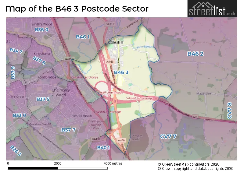
Map of the B46 3 Postcode Sector
Explore the B46 3 postcode sector by using our free interactive map.
| B | 4 | 6 | - | 3 | X | X |
| B | 4 | 6 | Space | 3 | Letter | Letter |
Official List of Streets
Coleshill (47 Streets)
Unofficial Streets or Alternative Spellings
Coleshill
BIRMINGHAM ROAD BLYTHE ROAD HAWTHORNE WALK ANGEL MEWS CHAMBERLAIN WALK COLESHILL INTERCHANGE FAIRVIEW MEWS FERNDALE COURT HIGH LODGE MACFARLANE WAY MOTTS WALK NORTHWAY ISLAND THE DRIVE VICTORIA WAYCastle Bromwich
CHESTER ROADBirmingham Business Park
SOLIHULL PARKWAYSchools and Places of Education Within the B46 3 Postcode Sector
Coleshill Church of England Primary School
Academy converter
Wingfield Road, Birmingham, West Midlands, B46 3LL
Head: Mr Matthew Edwards
Ofsted Rating: Good
Inspection: 2022-02-16 (837 days ago)
Website: Visit Coleshill Church of England Primary School Website
Phone: 01675463672
Number of Pupils: 409
The Coleshill School
Academy converter
Coventry Road, Birmingham, Warwickshire, B46 3EX
Head: Miss Rebecca Brindley
Ofsted Rating: Good
Inspection: 2020-03-04 (1551 days ago)
Website: Visit The Coleshill School Website
Phone: 01675462435
Number of Pupils: 1235
Woodlands
Academy special converter
Packington Lane, Birmingham, West Midlands, B46 3JE
Head: Mrs Sue Backhouse
Ofsted Rating: Requires improvement
Inspection: 2023-11-29 (186 days ago)
Website: Visit Woodlands Website
Phone: 01675463590
Number of Pupils: 217
House Prices in the B46 3 Postcode Sector
| Type of Property | 2018 Average | 2018 Sales | 2017 Average | 2017 Sales | 2016 Average | 2016 Sales | 2015 Average | 2015 Sales |
|---|---|---|---|---|---|---|---|---|
| Detached | £418,147 | 17 | £414,944 | 9 | £368,312 | 36 | £362,276 | 23 |
| Semi-Detached | £271,906 | 16 | £240,735 | 14 | £283,632 | 11 | £221,071 | 7 |
| Terraced | £192,250 | 8 | £181,580 | 15 | £188,926 | 17 | £216,171 | 42 |
| Flats | £158,808 | 13 | £141,746 | 12 | £196,409 | 23 | £163,478 | 53 |
Important Postcodes B46 3 in the Postcode Sector
B46 3EX is the postcode for D BLOCK, Coleshill School, Coventry Road, PRACTICAL BLOCK, The Coleshill School, Coventry Road, MAIN BUILDING, The Coleshill School, Coventry Road, BLOCK E, Coleshill School, Coventry Road, and E BLOCK, Coleshill School, Coventry Road
B46 3JE is the postcode for St. Edwards RC Primary School, Packington Lane, Coleshill, Coleshill Leisure Centre, Packington Lane, Coleshill, St. Edwards RC Primary School, Packington Lane, Woodlands School, Packington Lane, Coleshill, Coleshill Leisure Centre, Packington Lane, and Woodlands School, Packington Lane
B46 3LA is the postcode for Coleshill Leisure Centre, Park Road
B46 3LD is the postcode for 27, Parkfield Road, Coleshill
B46 3LL is the postcode for Coleshill C of E Primary School, Wingfield Road, Orchard Blythe, 3 Wingfield Road, Coleshill Cof E Primary School, Wingfield Road, Coleshilll, and Coleshill C of E Primary School, Wingfield Road, Coleshilll
| The B46 3 Sector is within these Local Authorities |
|
|---|---|
| The B46 3 Sector is within these Counties |
|
| The B46 3 Sector is within these Water Company Areas |
|