The B71 1 postcode sector is within the county of West Midlands.
Did you know? According to the 2021 Census, the B71 1 postcode sector is home to a bustling 8,978 residents!
Given that each sector allows for 400 unique postcode combinations. Letters C, I, K, M, O and V are not allowed in the last two letters of a postcode. With 195 postcodes already in use, this leaves 205 units available.
The B71 1 postal code covers the settlement of WEST BROMWICH.
The B71 1 Postcode shares a border with B70 8 (WEST BROMWICH), B71 3 (WEST BROMWICH), B70 0 (WEST BROMWICH, Hill Top, Golds Hill), B70 9 (WEST BROMWICH), B71 2 (WEST BROMWICH) and B71 4 (WEST BROMWICH, Sandwell).
The sector is within the post town of WEST BROMWICH.
B71 1 is a postcode sector within the B7 postcode district which is within the B Birmingham postcode area.
The Royal Mail delivery office for the B71 1 postal sector is the unknown.
The area of the B71 1 postcode sector is 0.59 square miles which is 1.52 square kilometres or 375.89 square acres.

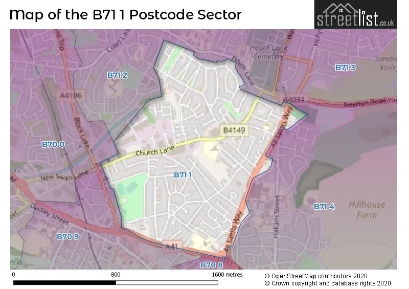
Map of the B71 1 Postcode Sector
Explore the B71 1 postcode sector by using our free interactive map.
| B | 7 | 1 | - | 1 | X | X |
| B | 7 | 1 | Space | 1 | Letter | Letter |
Official List of Streets
WEST BROMWICH (91 Streets)
Unofficial Streets or Alternative Spellings
Schools and Places of Education Within the B71 1 Postcode Sector
All Saints CofE Primary School
Voluntary aided school
Wilford Road, West Bromwich, West Midlands, B71 1QN
Head: Mrs Jacqueline Beech
Ofsted Rating: Good
Inspection: 2019-01-16 (1954 days ago)
Website: Visit All Saints CofE Primary School Website
Phone: 01215670033
Number of Pupils: 459
Hargate Primary School
Community school
Hargate Lane, West Bromwich, West Midlands, B71 1PG
Head: Mr Andrew Orgill
Ofsted Rating: Outstanding
Inspection: 2017-03-29 (2612 days ago)
Website: Visit Hargate Primary School Website
Phone: 01215534178
Number of Pupils: 485
St Mary Magdalene CofE Voluntary Controlled Primary School
Voluntary controlled school
Stanway Road, West Bromwich, West Midlands, B71 1RP
Head: Mrs Kelly Duff
Ofsted Rating: Outstanding
Inspection: 2014-01-23 (3773 days ago)
Website: Visit St Mary Magdalene CofE Voluntary Controlled Primary School Website
Phone: 01215882371
Number of Pupils: 235
House Prices in the B71 1 Postcode Sector
| Type of Property | 2018 Average | 2018 Sales | 2017 Average | 2017 Sales | 2016 Average | 2016 Sales | 2015 Average | 2015 Sales |
|---|---|---|---|---|---|---|---|---|
| Detached | £211,500 | 2 | £161,000 | 2 | £210,496 | 6 | £163,750 | 4 |
| Semi-Detached | £150,302 | 33 | £136,417 | 36 | £137,286 | 28 | £125,152 | 23 |
| Terraced | £130,980 | 25 | £120,597 | 26 | £109,139 | 28 | £106,625 | 16 |
| Flats | £73,417 | 12 | £80,417 | 6 | £70,500 | 8 | £76,000 | 8 |
Important Postcodes B71 1 in the Postcode Sector
B71 1PD is the postcode for West Bromwich Fire Station, Hargate Lane, and West Midlands Fire & Rescue Service, Station D8, Hargate Lane
B71 1PG is the postcode for Hargate Primary School, Hargate Lane
B71 1QN is the postcode for P & C BLOCK, Alexandra High School and Sixth Form Centre, Wilford Road, All Saints C of E Primary School, Wilford Road, SPORTS & TOWER BLOCK, Alexandra High School and Sixth Form Centre, Wilford Road, OLD BLOCK, Alexandra High School and Sixth Form Centre, Wilford Road, All Saints Church Of England Primary School, Wilford Road, and NEW TEACHING BLOCK, Alexandra High School and Sixth Form Centre, Wilford Road
B71 1QS is the postcode for West Bromwich Community Centre, Gayton Road
B71 1RP is the postcode for St. Mary Magdalene Primary School, All Saints Way, and St Mary Magdalene Church Of England Primary School, Stanway Road
B71 1RR is the postcode for Churchfields Community Pavilion, All Saints Way
| The B71 1 Sector is within these Local Authorities |
|
|---|---|
| The B71 1 Sector is within these Counties |
|
| The B71 1 Sector is within these Water Company Areas |
|