The BS27 postcode district is a postal district located in the BS Bristol postcode area with a population of 7,499 residents according to the 2021 England and Wales Census.
The area of the BS27 postcode district is 12.22 square miles which is 31.64 square kilometres or 7,818.23 acres.
Currently, the BS27 district has about 283 postcode units spread across 1 geographic postcode sectors.
Given that each sector allows for 400 unique postcode combinations, the district has a capacity of 400 postcodes. With 283 postcodes already in use, this leaves 117 units available.
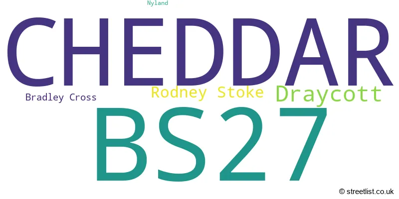
The largest settlement in the BS27 postal code is CHEDDAR followed by Draycott, and Rodney Stoke.
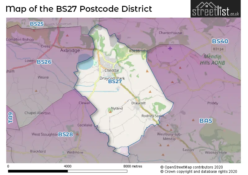
The BS27 Postcode shares a border with BS40 (Wrington, Langford, Winford), BA5 (WELLS, Wookey, Westbury Sub Mendip), BS25 (WINSCOMBE, Sandford, Shipham) and BS28 (WEDMORE, Blackford, Theale).
In the BS27 postcode district in Somerset, the primary settlement is Cheddar. Other significant settlements in the district include Bradley Cross, Draycott, Nyland, and Rodney Stoke. The district is located in the county of Somerset in England. The post town associated with the district is Cheddar.
For the district BS27, we have data on 2 postcode sectors. Here's a breakdown: The sector BS27 3, covers Cheddar and Draycott in Somerset. The sector BS27 9 is non-geographic. It's often designated for PO Boxes, large organisations, or special services.
BS27 Postcode Sectors

Map of the BS27 Postcode District
Explore the BS27 postcode district by using our free interactive map.
When it comes to local government, postal geography often disregards political borders. However, for a breakdown in the BS27 District: the district mostly encompasses the Somerset area with a total of 293 postcodes.
Where is the BS27 Postcode District?
The postcode district BS27 is located in Cheddar. Cheddar is near the towns of Axbridge (2.4 miles to the North West), Wedmore (4.0 miles to the South West), Glastonbury (8.3 miles to the South), Highbridge (9.3 miles to the West), and Wells (9.7 miles to the South East). Cheddar is also 115.4 miles away from the centre of London.
The district is within the post town of CHEDDAR.
The sector has postcodes within the nation of England.
The BS27 Postcode District is in the Somerset region of Dorset and Somerset within the South West (England).
Weather Forecast for BS27
Press Button to Show Forecast for Cheddar Youth Hostel
| Time Period | Icon | Description | Temperature | Rain Probability | Wind |
|---|---|---|---|---|---|
| 15:00 to 18:00 | Cloudy | 23.0°C (feels like 21.0°C) | 4.00% | SE 9 mph | |
| 18:00 to 21:00 | Cloudy | 21.0°C (feels like 20.0°C) | 4.00% | SE 7 mph | |
| 21:00 to 00:00 | Cloudy | 17.0°C (feels like 15.0°C) | 4.00% | ESE 7 mph |
Press Button to Show Forecast for Cheddar Youth Hostel
| Time Period | Icon | Description | Temperature | Rain Probability | Wind |
|---|---|---|---|---|---|
| 00:00 to 03:00 | Cloudy | 15.0°C (feels like 14.0°C) | 3.00% | E 7 mph | |
| 03:00 to 06:00 | Cloudy | 12.0°C (feels like 12.0°C) | 4.00% | NNE 4 mph | |
| 06:00 to 09:00 | Cloudy | 15.0°C (feels like 14.0°C) | 4.00% | N 4 mph | |
| 09:00 to 12:00 | Cloudy | 19.0°C (feels like 19.0°C) | 5.00% | SSE 4 mph | |
| 12:00 to 15:00 | Light rain shower (day) | 22.0°C (feels like 21.0°C) | 36.00% | SSE 9 mph | |
| 15:00 to 18:00 | Light rain shower (day) | 21.0°C (feels like 21.0°C) | 42.00% | SSW 7 mph | |
| 18:00 to 21:00 | Light rain shower (day) | 17.0°C (feels like 16.0°C) | 28.00% | WSW 7 mph | |
| 21:00 to 00:00 | Cloudy | 13.0°C (feels like 13.0°C) | 8.00% | W 7 mph |
Press Button to Show Forecast for Cheddar Youth Hostel
| Time Period | Icon | Description | Temperature | Rain Probability | Wind |
|---|---|---|---|---|---|
| 00:00 to 03:00 | Overcast | 12.0°C (feels like 12.0°C) | 9.00% | WSW 4 mph | |
| 03:00 to 06:00 | Overcast | 12.0°C (feels like 11.0°C) | 13.00% | SSW 4 mph | |
| 06:00 to 09:00 | Overcast | 13.0°C (feels like 11.0°C) | 14.00% | S 11 mph | |
| 09:00 to 12:00 | Overcast | 14.0°C (feels like 11.0°C) | 22.00% | SSE 16 mph | |
| 12:00 to 15:00 | Light rain | 14.0°C (feels like 11.0°C) | 58.00% | SSE 18 mph | |
| 15:00 to 18:00 | Heavy rain | 14.0°C (feels like 12.0°C) | 86.00% | SSE 16 mph | |
| 18:00 to 21:00 | Heavy rain | 14.0°C (feels like 12.0°C) | 92.00% | S 13 mph | |
| 21:00 to 00:00 | Heavy rain | 13.0°C (feels like 11.0°C) | 81.00% | S 9 mph |
Press Button to Show Forecast for Cheddar Youth Hostel
| Time Period | Icon | Description | Temperature | Rain Probability | Wind |
|---|---|---|---|---|---|
| 00:00 to 03:00 | Cloudy | 12.0°C (feels like 10.0°C) | 23.00% | SSE 9 mph | |
| 03:00 to 06:00 | Cloudy | 11.0°C (feels like 9.0°C) | 12.00% | SSE 9 mph | |
| 06:00 to 09:00 | Cloudy | 12.0°C (feels like 9.0°C) | 14.00% | SSE 11 mph | |
| 09:00 to 12:00 | Partly cloudy (day) | 13.0°C (feels like 11.0°C) | 17.00% | SSE 16 mph | |
| 12:00 to 15:00 | Light rain shower (day) | 15.0°C (feels like 12.0°C) | 43.00% | S 16 mph | |
| 15:00 to 18:00 | Light rain shower (day) | 15.0°C (feels like 12.0°C) | 42.00% | S 16 mph | |
| 18:00 to 21:00 | Light rain shower (day) | 14.0°C (feels like 11.0°C) | 41.00% | S 13 mph | |
| 21:00 to 00:00 | Partly cloudy (night) | 12.0°C (feels like 10.0°C) | 8.00% | S 11 mph |
Press Button to Show Forecast for Cheddar Youth Hostel
| Time Period | Icon | Description | Temperature | Rain Probability | Wind |
|---|---|---|---|---|---|
| 00:00 to 03:00 | Partly cloudy (night) | 11.0°C (feels like 9.0°C) | 7.00% | S 11 mph | |
| 03:00 to 06:00 | Cloudy | 11.0°C (feels like 9.0°C) | 9.00% | SSE 11 mph | |
| 06:00 to 09:00 | Partly cloudy (day) | 11.0°C (feels like 9.0°C) | 7.00% | S 11 mph | |
| 09:00 to 12:00 | Light rain shower (day) | 13.0°C (feels like 11.0°C) | 37.00% | S 13 mph | |
| 12:00 to 15:00 | Light rain shower (day) | 14.0°C (feels like 12.0°C) | 37.00% | S 13 mph | |
| 15:00 to 18:00 | Light rain shower (day) | 14.0°C (feels like 12.0°C) | 39.00% | SSW 13 mph | |
| 18:00 to 21:00 | Light rain shower (day) | 13.0°C (feels like 11.0°C) | 35.00% | SSW 11 mph | |
| 21:00 to 00:00 | Partly cloudy (night) | 11.0°C (feels like 9.0°C) | 5.00% | S 9 mph |
Postcode Sectors within the BS27 District
| Postcode Sector | Delivery Office |
|---|---|
| BS27 3 | Cheddar Delivery Office |
| B | S | 2 | 7 | - | X | X | X |
| B | S | 2 | 7 | Space | Numeric | Letter | Letter |
Current Monthly Rental Prices
| # Bedrooms | Min Price | Max Price | Avg Price |
|---|---|---|---|
| 2 | £950 | £1,000 | £975 |
Current House Prices
| # Bedrooms | Min Price | Max Price | Avg Price |
|---|---|---|---|
| 2 | £450,000 | £450,000 | £450,000 |
| 3 | £579,000 | £579,000 | £579,000 |
| 4 | £445,000 | £750,000 | £533,666 |
| 5 | £475,000 | £1,950,000 | £915,000 |
| 6 | £685,000 | £700,000 | £692,500 |
| 8 | £550,000 | £550,000 | £550,000 |
Estate Agents who Operate in the BS27 District
| Logo | Name | Brand Name | Address | Contact Number | Total Properties |
|---|---|---|---|---|---|
 | Cheddar | Laurel & Wylde | 2 Bath Street, Cheddar, BS27 3AA | 01934 315048 | 19 |
 | Cheddar | Cooper & Tanner | 2 Saxon Court Union Street, Cheddar, BS27 3NA | 01934 314984 | 18 |
 | Weston Super Mare | Saxons Estate Agents | 21 Boulevard Weston-Super-Mare BS23 1NR | 01934 315066 | 3 |
 | Lytham | Sell My Group | The Old Bakery Green Street, Lytham, Lytham St. Annes, FY8 5LG | 020 3910 6164 | 3 |
 | Wells | Greenslade Taylor Hunt | 74 High Street, Wells, Somerset, BA5 2AJ | 020 3869 5822 | 2 |
Yearly House Price Averages for the BS27 Postcode District
| Type of Property | 2018 Average | 2018 Sales | 2017 Average | 2017 Sales | 2016 Average | 2016 Sales | 2015 Average | 2015 Sales |
|---|---|---|---|---|---|---|---|---|
| Detached | £383,860 | 64 | £366,229 | 68 | £340,120 | 56 | £331,589 | 62 |
| Semi-Detached | £266,395 | 33 | £241,984 | 29 | £248,359 | 32 | £264,660 | 36 |
| Terraced | £253,881 | 21 | £184,969 | 18 | £197,748 | 20 | £192,960 | 26 |
| Flats | £133,925 | 12 | £125,499 | 20 | £120,194 | 18 | £123,523 | 20 |