The BS32 postcode district is a postal district located in the BS Bristol postcode area with a population of 24,755 residents according to the 2021 England and Wales Census.
The area of the BS32 postcode district is 10.19 square miles which is 26.39 square kilometres or 6,521.85 acres.
Currently, the BS32 district has about 429 postcode units spread across 4 geographic postcode sectors.
Given that each sector allows for 400 unique postcode combinations, the district has a capacity of 1,600 postcodes. With 429 postcodes already in use, this leaves 1171 units available.
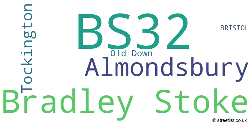
The largest settlement in the BS32 postal code is Bradley Stoke followed by Almondsbury, and Tockington.
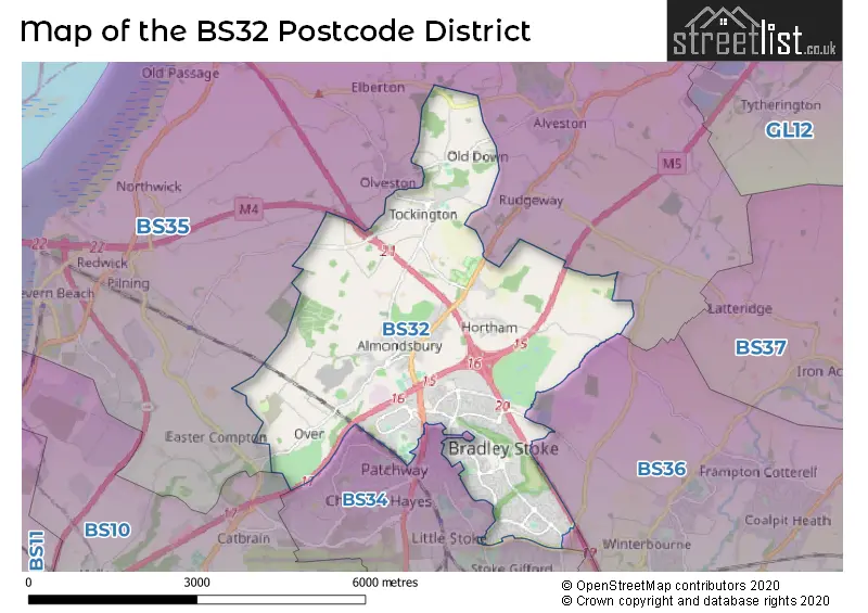
The BS32 Postcode shares a border with BS36 (Frampton Cotterell, Winterbourne, Coalpit Heath), BS16 (BRISTOL, Emersons Green, Mangotsfield), BS34 (Patchway, Stoke Gifford, Filton) and BS35 (Thornbury, Alveston, Severn Beach).
In the BS32 postcode district, the primary settlement is Bradley Stoke, located in the county of Gloucestershire, England. Other significant settlements in this district include Almondsbury, Old Down, and Tockington. The most significant post town in this district is Bristol.
For the district BS32, we have data on 4 postcode sectors. Here's a breakdown: The sector BS32 0, covers Bradley Stoke in Gloucestershire. The sector BS32 4, covers Almondsbury and Tockington and Bradley Stoke in Gloucestershire. The sector BS32 8, covers Bradley Stoke in Gloucestershire. The sector BS32 9, covers Bradley Stoke in Gloucestershire.

Map of the BS32 Postcode District
Explore the BS32 postcode district by using our free interactive map.
When it comes to local government, postal geography often disregards political borders. However, for a breakdown in the BS32 District: the district mostly encompasses the South Gloucestershire area with a total of 429 postcodes.
Weather Forecast for BS32
Press Button to Show Forecast for Almondsbury
| Time Period | Icon | Description | Temperature | Rain Probability | Wind |
|---|---|---|---|---|---|
| 06:00 to 09:00 | Cloudy | 5.0°C (feels like 3.0°C) | 8.00% | ENE 7 mph | |
| 09:00 to 12:00 | Cloudy | 8.0°C (feels like 5.0°C) | 10.00% | E 7 mph | |
| 12:00 to 15:00 | Overcast | 10.0°C (feels like 8.0°C) | 15.00% | E 9 mph | |
| 15:00 to 18:00 | Overcast | 11.0°C (feels like 9.0°C) | 19.00% | E 7 mph | |
| 18:00 to 21:00 | Overcast | 9.0°C (feels like 8.0°C) | 19.00% | E 7 mph | |
| 21:00 to 00:00 | Cloudy | 8.0°C (feels like 6.0°C) | 16.00% | ENE 4 mph |
Press Button to Show Forecast for Almondsbury
| Time Period | Icon | Description | Temperature | Rain Probability | Wind |
|---|---|---|---|---|---|
| 00:00 to 03:00 | Cloudy | 6.0°C (feels like 4.0°C) | 14.00% | E 7 mph | |
| 03:00 to 06:00 | Cloudy | 6.0°C (feels like 3.0°C) | 14.00% | ENE 7 mph | |
| 06:00 to 09:00 | Cloudy | 5.0°C (feels like 2.0°C) | 22.00% | NE 7 mph | |
| 09:00 to 12:00 | Light rain | 7.0°C (feels like 4.0°C) | 52.00% | ENE 9 mph | |
| 12:00 to 15:00 | Overcast | 10.0°C (feels like 8.0°C) | 21.00% | ENE 9 mph | |
| 15:00 to 18:00 | Cloudy | 11.0°C (feels like 9.0°C) | 16.00% | ENE 9 mph | |
| 18:00 to 21:00 | Overcast | 10.0°C (feels like 8.0°C) | 22.00% | NE 9 mph | |
| 21:00 to 00:00 | Light rain | 8.0°C (feels like 6.0°C) | 50.00% | NE 9 mph |
Press Button to Show Forecast for Almondsbury
| Time Period | Icon | Description | Temperature | Rain Probability | Wind |
|---|---|---|---|---|---|
| 00:00 to 03:00 | Light rain | 7.0°C (feels like 5.0°C) | 51.00% | NE 7 mph | |
| 03:00 to 06:00 | Light rain | 7.0°C (feels like 4.0°C) | 52.00% | NE 7 mph | |
| 06:00 to 09:00 | Light rain | 7.0°C (feels like 4.0°C) | 52.00% | NE 7 mph | |
| 09:00 to 12:00 | Heavy rain | 9.0°C (feels like 6.0°C) | 73.00% | NNE 9 mph | |
| 12:00 to 15:00 | Light rain shower (day) | 11.0°C (feels like 9.0°C) | 44.00% | N 11 mph | |
| 15:00 to 18:00 | Light rain shower (day) | 12.0°C (feels like 9.0°C) | 44.00% | NW 9 mph | |
| 18:00 to 21:00 | Light rain shower (day) | 11.0°C (feels like 9.0°C) | 35.00% | NNW 9 mph | |
| 21:00 to 00:00 | Partly cloudy (night) | 8.0°C (feels like 7.0°C) | 7.00% | NW 7 mph |
Where is the BS32 Postcode District?
The postcode district for BS32 is located in Bristol. It is near several towns in different directions. To the North West, there is Chepstow which is approximately 7.5 miles away. Caldicot is located to the West and is around 8.9 miles away. Wotton-Under-Edge can be found to the North East, approximately 10.5 miles away. Badminton is situated to the East, around 11.2 miles away. Lydney is to the North, approximately 11.8 miles away. Lastly, Bath is located to the South East, around 14.3 miles away. The postcode district is also about 105 miles away from the center of London.
The district is within the post town of BRISTOL.
The sector has postcodes within the nation of England.
The BS32 Postcode District is in the Bath and North East Somerset, North Somerset and South Gloucestershire region of Gloucestershire, Wiltshire and Bath/Bristol area within the South West (England).
| Postcode Sector | Delivery Office |
|---|---|
| BS32 0 | Patchway Delivery Office |
| BS32 4 | Patchway Delivery Office |
| BS32 8 | Patchway Delivery Office |
| BS32 9 | Patchway Delivery Office |
| B | S | 3 | 2 | - | X | X | X |
| B | S | 3 | 2 | Space | Numeric | Letter | Letter |
Current Monthly Rental Prices
| # Bedrooms | Min Price | Max Price | Avg Price |
|---|---|---|---|
| 1 | £1,400 | £2,500 | £1,975 |
| 2 | £1,200 | £2,500 | £1,505 |
| 3 | £1,650 | £1,800 | £1,725 |
| 4 | £1,600 | £3,000 | £2,260 |
| 5 | £2,500 | £2,500 | £2,500 |
Current House Prices
| # Bedrooms | Min Price | Max Price | Avg Price |
|---|---|---|---|
| 4 | £600,000 | £950,000 | £721,330 |
| 5 | £700,000 | £1,495,000 | £818,125 |
| 6 | £625,000 | £675,000 | £650,000 |
Estate Agents who Operate in the BS32 District
| Logo | Name | Brand Name | Address | Contact Number | Total Properties |
|---|---|---|---|---|---|
 | Bradley Stoke | CJ Hole | Sales & Lettings Property Centre, Willow Brook Centre, Savages Wood Road, Bradley Stoke, Bristol, BS32 8BS | 01454 803161 | 25 |
 | Bradley Stoke | Taylors Estate Agents | Unit 3 Town Square, Willow Brook Centre, Savages Wood Road, Bradley Stoke, Bristol, BS32 8FB | 01454 802678 | 25 |
 | Bradley Stoke | Ocean | Willow Brook Centre, Savages Wood Road, Bradley Stoke, Bristol, BS32 8EF | 01454 801995 | 17 |
 | Bristol | Hopewell | Hope Chapel House, Hope Chapel Hill, Clifton, BS8 4ND | 0117 463 0268 | 9 |
 | Patchway | West Coast Properties | 5 Coniston Road, Patchway, Bristol, BS34 5PA | 0117 463 0162 | 6 |
| Type of Property | 2018 Average | 2018 Sales | 2017 Average | 2017 Sales | 2016 Average | 2016 Sales | 2015 Average | 2015 Sales |
|---|---|---|---|---|---|---|---|---|
| Detached | £390,696 | 133 | £407,447 | 139 | £359,623 | 130 | £382,601 | 161 |
| Semi-Detached | £262,745 | 63 | £254,011 | 81 | £259,747 | 77 | £248,206 | 72 |
| Terraced | £254,417 | 163 | £228,177 | 136 | £221,485 | 152 | £208,515 | 189 |
| Flats | £177,623 | 53 | £158,295 | 56 | £156,862 | 65 | £148,465 | 62 |