The BS8 postcode district is a postal district located in the BS Bristol postcode area with a population of 27,237 residents according to the 2021 England and Wales Census.
The area of the BS8 postcode district is 8.70 square miles which is 22.53 square kilometres or 5,568.35 acres.
Currently, the BS8 district has about 834 postcode units spread across 4 geographic postcode sectors.
Given that each sector allows for 400 unique postcode combinations, the district has a capacity of 1,600 postcodes. With 834 postcodes already in use, this leaves 766 units available.
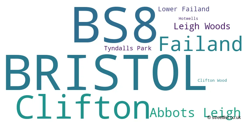
The largest settlement in the BS8 postal code is BRISTOL followed by Clifton, and Failand.
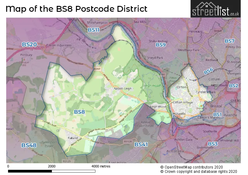
The BS8 Postcode shares a border with BS41 (Long Ashton, Dundry), BS3 (BRISTOL, Bedminster, Southville), BS48 (Nailsea, Backwell, Wraxall), BS6 (BRISTOL, St. Andrews, Redland), BS1 (BRISTOL, Redcliffe) and BS20 (Portishead, Pill, Easton-in-Gordano).
The primary settlement in the BS8 postcode district is Bristol. It is located in the county of Bristol in England. Other significant settlements in this district include Clifton, Tyndalls Park, Abbots Leigh, Failand, Leigh Woods, Lower Failand, and Clifton Wood. The most significant post town in this district is Bristol.
For the district BS8, we have data on 5 postcode sectors. Here's a breakdown: The sector BS8 1, covers Bristol and Clifton in Bristol. The sector BS8 2, covers Bristol and Clifton in Bristol. The sector BS8 3, covers Bristol and Clifton in Bristol. The sector BS8 3, covers Failand and Abbots Leigh in Somerset. The sector BS8 4, covers Bristol and Clifton in Bristol. The sector BS8 9 is non-geographic. It's often designated for PO Boxes, large organisations, or special services.

Map of the BS8 Postcode District
Explore the BS8 postcode district by using our free interactive map.
When it comes to local government, postal geography often disregards political borders. However, for a breakdown in the BS8 District: the district mostly encompasses the City of Bristol (B) (721 postcodes), and finally, the North Somerset area (111 postcodes).
Weather Forecast for BS8
Press Button to Show Forecast for Sneyd Park
| Time Period | Icon | Description | Temperature | Rain Probability | Wind |
|---|---|---|---|---|---|
| 03:00 to 06:00 | Overcast | 6.0°C (feels like 5.0°C) | 8.00% | ENE 7 mph | |
| 06:00 to 09:00 | Cloudy | 6.0°C (feels like 4.0°C) | 8.00% | ENE 7 mph | |
| 09:00 to 12:00 | Cloudy | 8.0°C (feels like 5.0°C) | 10.00% | E 9 mph | |
| 12:00 to 15:00 | Overcast | 10.0°C (feels like 8.0°C) | 15.00% | E 9 mph | |
| 15:00 to 18:00 | Overcast | 10.0°C (feels like 8.0°C) | 19.00% | E 9 mph | |
| 18:00 to 21:00 | Cloudy | 10.0°C (feels like 8.0°C) | 17.00% | E 9 mph | |
| 21:00 to 00:00 | Cloudy | 8.0°C (feels like 6.0°C) | 16.00% | ENE 7 mph |
Press Button to Show Forecast for Sneyd Park
| Time Period | Icon | Description | Temperature | Rain Probability | Wind |
|---|---|---|---|---|---|
| 00:00 to 03:00 | Cloudy | 7.0°C (feels like 5.0°C) | 14.00% | ENE 7 mph | |
| 03:00 to 06:00 | Cloudy | 6.0°C (feels like 4.0°C) | 14.00% | ENE 9 mph | |
| 06:00 to 09:00 | Cloudy | 6.0°C (feels like 3.0°C) | 20.00% | NE 9 mph | |
| 09:00 to 12:00 | Overcast | 7.0°C (feels like 4.0°C) | 25.00% | ENE 11 mph | |
| 12:00 to 15:00 | Overcast | 9.0°C (feels like 7.0°C) | 21.00% | ENE 11 mph | |
| 15:00 to 18:00 | Cloudy | 11.0°C (feels like 8.0°C) | 16.00% | ENE 11 mph | |
| 18:00 to 21:00 | Overcast | 10.0°C (feels like 8.0°C) | 22.00% | NE 11 mph | |
| 21:00 to 00:00 | Light rain | 9.0°C (feels like 6.0°C) | 48.00% | NE 11 mph |
Press Button to Show Forecast for Sneyd Park
| Time Period | Icon | Description | Temperature | Rain Probability | Wind |
|---|---|---|---|---|---|
| 00:00 to 03:00 | Light rain | 8.0°C (feels like 5.0°C) | 51.00% | NE 11 mph | |
| 03:00 to 06:00 | Light rain | 7.0°C (feels like 5.0°C) | 52.00% | NE 11 mph | |
| 06:00 to 09:00 | Light rain | 7.0°C (feels like 5.0°C) | 52.00% | NNE 9 mph | |
| 09:00 to 12:00 | Light rain | 9.0°C (feels like 6.0°C) | 52.00% | NE 11 mph | |
| 12:00 to 15:00 | Light rain shower (day) | 11.0°C (feels like 8.0°C) | 46.00% | NNW 11 mph | |
| 15:00 to 18:00 | Light rain | 11.0°C (feels like 9.0°C) | 54.00% | NW 11 mph | |
| 18:00 to 21:00 | Light rain shower (day) | 11.0°C (feels like 9.0°C) | 35.00% | NNW 9 mph | |
| 21:00 to 00:00 | Partly cloudy (night) | 9.0°C (feels like 7.0°C) | 7.00% | NNW 7 mph |
Where is the BS8 Postcode District?
The postcode district for BS8 is located in Bristol, which is a district town. Bristol is surrounded by several nearby towns. To the West is Clevedon, which is approximately 7.5 miles away. To the North West is Caldicot, which is around 10.4 miles away. Chepstow is situated to the North and is approximately 12.1 miles away. Winscombe is located to the South West, around 12.4 miles away. Lastly, Bath is situated to the South East and is approximately 13.2 miles away. Additionally, the distance from BS8 to London is approximately 109.5 miles.
The district is within the post town of BRISTOL.
The sector has postcodes within the nation of England.
The BS8 Postcode District is covers the following regions.
- Bristol, City of - Gloucestershire, Wiltshire and Bath/Bristol area - South West (England)
- Bath and North East Somerset, North Somerset and South Gloucestershire - Gloucestershire, Wiltshire and Bath/Bristol area - South West (England)
| Postcode Sector | Delivery Office |
|---|---|
| BS8 1 | Clifton (bs) Delivery Office |
| BS8 2 | Clifton (bs) Delivery Office |
| BS8 3 | Clifton (bs) Delivery Office |
| BS8 4 | Clifton (bs) Delivery Office |
| B | S | 8 | - | X | X | X |
| B | S | 8 | Space | Numeric | Letter | Letter |
Tourist Attractions within the Postcode Area
We found 2 visitor attractions within the BS8 postcode area
| Clifton Suspension Bridge Visitor Centre |
|---|
| Historic Properties |
| Historic Monument / Archaeological Site |
| View Clifton Suspension Bridge Visitor Centre on Google Maps |
| Bristol Zoo Gardens |
| Wildlife |
| Safari Park / Zoo / Aquarium / Aviary |
| View Bristol Zoo Gardens on Google Maps |
Current Monthly Rental Prices
| # Bedrooms | Min Price | Max Price | Avg Price |
|---|---|---|---|
| £2,600 | £2,600 | £2,600 | |
| 1 | £2,900 | £3,751 | £3,326 |
| 2 | £2,600 | £3,750 | £3,025 |
| 3 | £2,800 | £4,105 | £3,434 |
| 4 | £3,200 | £4,995 | £3,899 |
| 5 | £3,800 | £5,750 | £4,636 |
| 7 | £6,000 | £6,000 | £6,000 |
Current House Prices
| # Bedrooms | Min Price | Max Price | Avg Price |
|---|---|---|---|
| 2 | £350,000 | £895,000 | £622,500 |
| 3 | £895,000 | £1,195,000 | £997,000 |
| 4 | £825,000 | £1,495,000 | £1,060,000 |
| 5 | £895,000 | £3,250,000 | £1,723,571 |
| 6 | £1,000,000 | £2,800,000 | £1,623,750 |
Estate Agents who Operate in the BS8 District
| Logo | Name | Brand Name | Address | Contact Number | Total Properties |
|---|---|---|---|---|---|
 | Clifton | Allen & Harris | 23 Regent Street, Clifton, Bristol, Gloucestershire, BS8 4HW | 0117 463 6785 | 17 |
 | Bristol | Richard Harding | 124 Whiteladies Road, Clifton, Bristol, BS8 2RP | 0117 463 0311 | 12 |
 | Clifton | Savills | 20 The Mall, Bristol, BS8 4DR | 0117 463 4258 | 11 |
 | Clifton | Hydes of Bristol | 28 Princess Victoria Street Clifton Bristol BS8 4BU | 0117 463 0198 | 10 |
 | Bristol | Knight Frank | 1 The Mall, Clifton, Bristol BS8 4DP | 0117 463 8684 | 9 |
| Type of Property | 2018 Average | 2018 Sales | 2017 Average | 2017 Sales | 2016 Average | 2016 Sales | 2015 Average | 2015 Sales |
|---|---|---|---|---|---|---|---|---|
| Detached | £849,543 | 23 | £826,040 | 36 | £934,159 | 39 | £733,921 | 51 |
| Semi-Detached | £1,063,420 | 23 | £824,223 | 20 | £1,171,155 | 29 | £686,623 | 24 |
| Terraced | £668,606 | 89 | £749,504 | 83 | £682,372 | 80 | £622,523 | 96 |
| Flats | £386,385 | 344 | £395,539 | 363 | £354,538 | 399 | £322,471 | 426 |