The CM1 postcode district is a postal district located in the CM Chelmsford postcode area with a population of 69,427 residents according to the 2021 England and Wales Census.
The area of the CM1 postcode district is 37.51 square miles which is 97.16 square kilometres or 24,008.29 acres.
Currently, the CM1 district has about 1515 postcode units spread across 28 geographic postcode sectors.
Given that each sector allows for 400 unique postcode combinations, the district has a capacity of 11,200 postcodes. With 1515 postcodes already in use, this leaves 9685 units available.
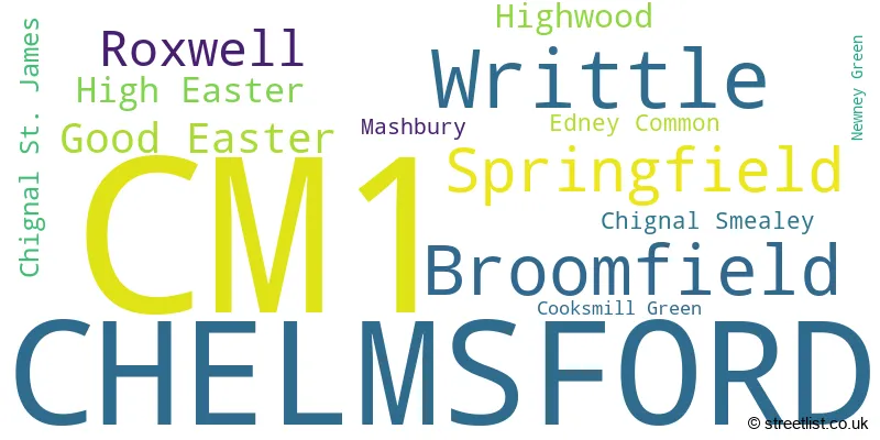
The largest settlement in the CM1 postal code is CHELMSFORD followed by Writtle, and Springfield.
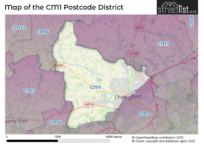
The CM1 Postcode shares a border with CM6 (DUNMOW, Thaxted, Felsted), CM2 (CHELMSFORD, Great Baddow, West Hanningfield), CM4 (INGATESTONE, Stock, Blackmore), CM5 (ONGAR, Fyfield, High Ongar) and CM3 (South Woodham Ferrers, Danbury, Hatfield Peverel).
The primary settlement in the CM1 postcode district is Chelmsford, located in the county of Essex. Other significant settlements in this postcode district include Cooksmill Green, Edney Common, Highwood, Newney Green, Roxwell, and Writtle. The most significant post town in this district is Chelmsford.
For the district CM1, we have data on 7 postcode sectors. Here's a breakdown: The sector CM1 1, covers Chelmsford in Essex. The sector CM1 2, covers Chelmsford in Essex. The sector CM1 3, covers Writtle and Chelmsford in Essex. The sector CM1 4, covers Chelmsford and Roxwell in Essex. The sector CM1 6, covers Chelmsford and Springfield in Essex. The sector CM1 7, covers Chelmsford and Broomfield in Essex. The sector CM1 9 is non-geographic. It's often designated for PO Boxes, large organisations, or special services.

Map of the CM1 Postcode District
Explore the CM1 postcode district by using our free interactive map.
When it comes to local government, postal geography often disregards political borders. However, for a breakdown in the CM1 District: the district mostly encompasses the Chelmsford District (B) (1527 postcodes), and finally, the Uttlesford District area (26 postcodes).
Weather Forecast for CM1
Press Button to Show Forecast for Boyton Cross
| Time Period | Icon | Description | Temperature | Rain Probability | Wind |
|---|---|---|---|---|---|
| 00:00 to 03:00 | Cloudy | 6.0°C (feels like 4.0°C) | 13.00% | ENE 9 mph | |
| 03:00 to 06:00 | Light rain | 6.0°C (feels like 3.0°C) | 56.00% | ENE 9 mph | |
| 06:00 to 09:00 | Heavy rain | 6.0°C (feels like 3.0°C) | 81.00% | NE 9 mph | |
| 09:00 to 12:00 | Light rain | 8.0°C (feels like 5.0°C) | 44.00% | NE 11 mph | |
| 12:00 to 15:00 | Light rain | 11.0°C (feels like 9.0°C) | 48.00% | NE 9 mph | |
| 15:00 to 18:00 | Cloudy | 12.0°C (feels like 10.0°C) | 9.00% | ENE 9 mph | |
| 18:00 to 21:00 | Cloudy | 11.0°C (feels like 9.0°C) | 18.00% | ENE 9 mph | |
| 21:00 to 00:00 | Light rain | 9.0°C (feels like 6.0°C) | 57.00% | NE 11 mph |
Press Button to Show Forecast for Boyton Cross
| Time Period | Icon | Description | Temperature | Rain Probability | Wind |
|---|---|---|---|---|---|
| 00:00 to 03:00 | Heavy rain | 9.0°C (feels like 6.0°C) | 89.00% | NNE 11 mph | |
| 03:00 to 06:00 | Heavy rain | 9.0°C (feels like 6.0°C) | 89.00% | NNE 11 mph | |
| 06:00 to 09:00 | Heavy rain | 9.0°C (feels like 7.0°C) | 84.00% | NW 7 mph | |
| 09:00 to 12:00 | Heavy rain | 10.0°C (feels like 7.0°C) | 78.00% | W 11 mph | |
| 12:00 to 15:00 | Heavy rain | 10.0°C (feels like 7.0°C) | 76.00% | W 13 mph | |
| 15:00 to 18:00 | Light rain | 10.0°C (feels like 8.0°C) | 50.00% | W 13 mph | |
| 18:00 to 21:00 | Cloudy | 10.0°C (feels like 8.0°C) | 11.00% | WSW 9 mph | |
| 21:00 to 00:00 | Partly cloudy (night) | 8.0°C (feels like 6.0°C) | 2.00% | SW 7 mph |
Press Button to Show Forecast for Boyton Cross
| Time Period | Icon | Description | Temperature | Rain Probability | Wind |
|---|---|---|---|---|---|
| 00:00 to 03:00 | Clear night | 6.0°C (feels like 4.0°C) | 2.00% | SW 7 mph | |
| 03:00 to 06:00 | Clear night | 5.0°C (feels like 3.0°C) | 2.00% | SSW 7 mph | |
| 06:00 to 09:00 | Sunny day | 7.0°C (feels like 5.0°C) | 1.00% | S 7 mph | |
| 09:00 to 12:00 | Partly cloudy (day) | 12.0°C (feels like 10.0°C) | 3.00% | SSW 9 mph | |
| 12:00 to 15:00 | Cloudy | 14.0°C (feels like 12.0°C) | 7.00% | S 11 mph | |
| 15:00 to 18:00 | Partly cloudy (day) | 15.0°C (feels like 12.0°C) | 3.00% | S 11 mph | |
| 18:00 to 21:00 | Sunny day | 13.0°C (feels like 11.0°C) | 2.00% | SSE 9 mph | |
| 21:00 to 00:00 | Clear night | 9.0°C (feels like 7.0°C) | 1.00% | SE 7 mph |
Press Button to Show Forecast for Boyton Cross
| Time Period | Icon | Description | Temperature | Rain Probability | Wind |
|---|---|---|---|---|---|
| 00:00 to 03:00 | Clear night | 8.0°C (feels like 6.0°C) | 2.00% | SE 7 mph | |
| 03:00 to 06:00 | Clear night | 7.0°C (feels like 5.0°C) | 4.00% | ESE 7 mph | |
| 06:00 to 09:00 | Cloudy | 9.0°C (feels like 7.0°C) | 9.00% | ESE 7 mph | |
| 09:00 to 12:00 | Cloudy | 13.0°C (feels like 12.0°C) | 7.00% | ESE 9 mph | |
| 12:00 to 15:00 | Cloudy | 15.0°C (feels like 13.0°C) | 12.00% | SE 9 mph | |
| 15:00 to 18:00 | Cloudy | 16.0°C (feels like 14.0°C) | 11.00% | SE 11 mph | |
| 18:00 to 21:00 | Cloudy | 14.0°C (feels like 12.0°C) | 10.00% | ESE 9 mph | |
| 21:00 to 00:00 | Overcast | 11.0°C (feels like 10.0°C) | 14.00% | ESE 7 mph |
Where is the CM1 Postcode District?
The postcode district CM1 is located in the town of Chelmsford. Chelmsford is situated approximately 28.6 miles away from the center of London. It is surrounded by several nearby towns such as Ingatestone to the south (5.5 miles), Dunmow to the north (7.5 miles), Matching Green to the west (7.9 miles), Brentwood to the southwest (10.1 miles), and Witham to the northeast (10.4 miles).
The district is within the post town of CHELMSFORD.
The sector has postcodes within the nation of England.
The CM1 Postcode District is covers the following regions.
- Heart of Essex - Essex - East of England
- West Essex - Essex - East of England
Postcode Sectors within the CM1 District
| Postcode Sector | Delivery Office |
|---|---|
| CM1 1 | Chelmsford Delivery Office |
| CM1 2 | Chelmsford Delivery Office |
| CM1 3 | Chelmsford Delivery Office |
| CM1 4 | Chelmsford Delivery Office |
| CM1 6 | Chelmsford Delivery Office |
| CM1 7 | Chelmsford Delivery Office |
| C | M | 1 | - | X | X | X |
| C | M | 1 | Space | Numeric | Letter | Letter |
Current Monthly Rental Prices
| # Bedrooms | Min Price | Max Price | Avg Price |
|---|---|---|---|
| 2 | £1,500 | £2,500 | £1,739 |
| 3 | £1,525 | £1,850 | £1,652 |
| 4 | £1,800 | £5,500 | £2,791 |
| 5 | £4,500 | £4,500 | £4,500 |
Current House Prices
| # Bedrooms | Min Price | Max Price | Avg Price |
|---|---|---|---|
| £3,000,000 | £3,000,000 | £3,000,000 | |
| 3 | £1,250,000 | £1,250,000 | £1,250,000 |
| 4 | £1,150,000 | £1,875,000 | £1,515,000 |
| 5 | £1,100,000 | £2,500,000 | £1,426,500 |
| 6 | £1,250,000 | £1,250,000 | £1,250,000 |
| 7 | £2,800,000 | £2,800,000 | £2,800,000 |
| 10 | £1,250,000 | £1,250,000 | £1,250,000 |
Estate Agents who Operate in the CM1 District
| Logo | Name | Brand Name | Address | Contact Number | Total Properties |
|---|---|---|---|---|---|
 | Chelmsford | haart | 65 Duke Street Chelmsford CM1 1LW | 01245 945473 | 70 |
 | Chelmsford | William H. Brown | 12/12a Duke Street, Chelmsford, Essex, CM1 1HL | 01245 945123 | 49 |
 | Chelmsford | Beresfords | 10 Duke Street, Chelmsford, CM1 1HL, | 01245 945593 | 41 |
 | Chelmsford | Adrians | 16 Duke Street Chelmsford CM1 1UP | 01245 945748 | 40 |
 | Chelmsford | Balch Estate Agents | The Millars Hospital Approach Broomfield Chelmsford CM1 7FA | 01245 945870 | 24 |
| Type of Property | 2018 Average | 2018 Sales | 2017 Average | 2017 Sales | 2016 Average | 2016 Sales | 2015 Average | 2015 Sales |
|---|---|---|---|---|---|---|---|---|
| Detached | £583,472 | 269 | £572,539 | 284 | £556,485 | 288 | £477,993 | 228 |
| Semi-Detached | £376,078 | 299 | £372,935 | 319 | £351,507 | 292 | £306,983 | 313 |
| Terraced | £323,029 | 201 | £322,751 | 267 | £318,406 | 342 | £283,446 | 350 |
| Flats | £221,830 | 301 | £213,849 | 392 | £206,773 | 410 | £194,038 | 412 |