The DA3 postcode district is a postal district located in the DA Dartford postcode area with a population of 17,119 residents according to the 2021 England and Wales Census.
The area of the DA3 postcode district is 8.73 square miles which is 22.60 square kilometres or 5,585.26 acres.
Currently, the DA3 district has about 354 postcode units spread across 2 geographic postcode sectors.
Given that each sector allows for 400 unique postcode combinations, the district has a capacity of 800 postcodes. With 354 postcodes already in use, this leaves 446 units available.
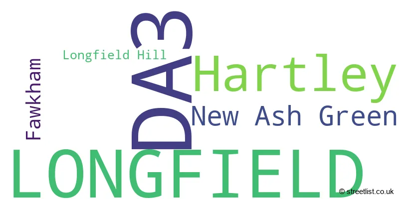
The largest settlement in the DA3 postal code is LONGFIELD followed by New Ash Green, and Hartley.
The DA3 Postcode shares a border with DA4 (South Darenth, EYNSFORD, Sutton At Hone), DA13 (Meopham, Istead Rise, Southfleet) and TN15 (West Kingsdown, Borough Green, KEMSING).
The primary settlement in the DA3 postcode district is Longfield, located in the county of Kent in England. Other significant settlements in the district include Fawkham, Hartley, and Longfield Hill. The post town associated with the district is Longfield.
For the district DA3, we have data on 3 postcode sectors. Here's a breakdown: The sector DA3 7, covers Longfield and Hartley in Kent. The sector DA3 8, covers New Ash Green and Hartley and Fawkham in Kent. The sector DA3 9 is non-geographic. It's often designated for PO Boxes, large organisations, or special services.

Map of the DA3 Postcode District
Explore the DA3 postcode district by using our free interactive map.
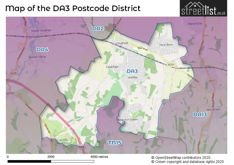
When it comes to local government, postal geography often disregards political borders. However, for a breakdown in the DA3 District: the district mostly encompasses the Sevenoaks District (246 postcodes), followed by the Dartford District (B) area (108 postcodes), and finally, the Gravesham District (B) area (3 postcodes).
Weather Forecast for DA3
Press Button to Show Forecast for Hartley
| Time Period | Icon | Description | Temperature | Rain Probability | Wind |
|---|---|---|---|---|---|
| 09:00 to 12:00 | Cloudy | 6.0°C (feels like 4.0°C) | 5.00% | NE 7 mph | |
| 12:00 to 15:00 | Cloudy | 9.0°C (feels like 7.0°C) | 5.00% | E 7 mph | |
| 15:00 to 18:00 | Overcast | 10.0°C (feels like 8.0°C) | 8.00% | ESE 9 mph | |
| 18:00 to 21:00 | Cloudy | 9.0°C (feels like 7.0°C) | 5.00% | E 9 mph | |
| 21:00 to 00:00 | Overcast | 7.0°C (feels like 5.0°C) | 13.00% | E 9 mph |
Press Button to Show Forecast for Hartley
| Time Period | Icon | Description | Temperature | Rain Probability | Wind |
|---|---|---|---|---|---|
| 00:00 to 03:00 | Light rain | 7.0°C (feels like 4.0°C) | 50.00% | ENE 9 mph | |
| 03:00 to 06:00 | Heavy rain | 6.0°C (feels like 3.0°C) | 80.00% | ENE 9 mph | |
| 06:00 to 09:00 | Light rain | 6.0°C (feels like 3.0°C) | 53.00% | NE 11 mph | |
| 09:00 to 12:00 | Cloudy | 8.0°C (feels like 6.0°C) | 17.00% | NE 9 mph | |
| 12:00 to 15:00 | Light rain shower (day) | 11.0°C (feels like 9.0°C) | 41.00% | ENE 9 mph | |
| 15:00 to 18:00 | Cloudy | 12.0°C (feels like 10.0°C) | 12.00% | ENE 9 mph | |
| 18:00 to 21:00 | Cloudy | 10.0°C (feels like 8.0°C) | 63.00% | ENE 11 mph | |
| 21:00 to 00:00 | Heavy rain | 9.0°C (feels like 6.0°C) | 88.00% | NE 11 mph |
Press Button to Show Forecast for Hartley
| Time Period | Icon | Description | Temperature | Rain Probability | Wind |
|---|---|---|---|---|---|
| 00:00 to 03:00 | Heavy rain | 9.0°C (feels like 6.0°C) | 91.00% | NE 11 mph | |
| 03:00 to 06:00 | Heavy rain | 9.0°C (feels like 7.0°C) | 89.00% | ENE 9 mph | |
| 06:00 to 09:00 | Heavy rain | 9.0°C (feels like 7.0°C) | 85.00% | W 9 mph | |
| 09:00 to 12:00 | Heavy rain | 9.0°C (feels like 7.0°C) | 81.00% | W 11 mph | |
| 12:00 to 15:00 | Light rain | 10.0°C (feels like 7.0°C) | 58.00% | W 13 mph | |
| 15:00 to 18:00 | Overcast | 10.0°C (feels like 8.0°C) | 19.00% | W 11 mph | |
| 18:00 to 21:00 | Cloudy | 10.0°C (feels like 8.0°C) | 10.00% | WSW 9 mph | |
| 21:00 to 00:00 | Partly cloudy (night) | 8.0°C (feels like 6.0°C) | 3.00% | SW 9 mph |
Press Button to Show Forecast for Hartley
| Time Period | Icon | Description | Temperature | Rain Probability | Wind |
|---|---|---|---|---|---|
| 00:00 to 03:00 | Clear night | 7.0°C (feels like 5.0°C) | 2.00% | SW 7 mph | |
| 03:00 to 06:00 | Clear night | 6.0°C (feels like 4.0°C) | 1.00% | SSW 7 mph | |
| 06:00 to 09:00 | Sunny day | 7.0°C (feels like 5.0°C) | 1.00% | S 7 mph | |
| 09:00 to 12:00 | Partly cloudy (day) | 11.0°C (feels like 10.0°C) | 3.00% | S 9 mph | |
| 12:00 to 15:00 | Cloudy | 14.0°C (feels like 11.0°C) | 7.00% | S 11 mph | |
| 15:00 to 18:00 | Cloudy | 14.0°C (feels like 12.0°C) | 5.00% | S 11 mph | |
| 18:00 to 21:00 | Sunny day | 13.0°C (feels like 11.0°C) | 4.00% | S 9 mph | |
| 21:00 to 00:00 | Clear night | 9.0°C (feels like 7.0°C) | 1.00% | SE 7 mph |
Press Button to Show Forecast for Hartley
| Time Period | Icon | Description | Temperature | Rain Probability | Wind |
|---|---|---|---|---|---|
| 00:00 to 03:00 | Clear night | 8.0°C (feels like 6.0°C) | 2.00% | SE 7 mph | |
| 03:00 to 06:00 | Clear night | 7.0°C (feels like 5.0°C) | 3.00% | SE 7 mph | |
| 06:00 to 09:00 | Cloudy | 9.0°C (feels like 7.0°C) | 9.00% | ESE 7 mph | |
| 09:00 to 12:00 | Cloudy | 13.0°C (feels like 11.0°C) | 8.00% | ESE 9 mph | |
| 12:00 to 15:00 | Cloudy | 15.0°C (feels like 13.0°C) | 12.00% | SE 9 mph | |
| 15:00 to 18:00 | Cloudy | 16.0°C (feels like 14.0°C) | 13.00% | SE 9 mph | |
| 18:00 to 21:00 | Cloudy | 14.0°C (feels like 13.0°C) | 10.00% | ESE 9 mph | |
| 21:00 to 00:00 | Cloudy | 12.0°C (feels like 10.0°C) | 10.00% | E 9 mph |
Where is the DA3 Postcode District?
The DA3 postcode district is located in the town of Longfield. It is situated approximately 2.5 miles north of Southfleet, 3 miles northwest of South Darenth, and 3.9 miles west of Farningham. Additionally, the postcode district of DA3 is around 20.4 miles away from the center of London.
The district is within the post town of LONGFIELD.
The sector has postcodes within the nation of England.
The DA3 Postcode District is covers the following regions.
- West Kent - Kent - South East (England)
- Kent Thames Gateway - Kent - South East (England)
| Postcode Sector | Delivery Office |
|---|---|
| DA3 7 | Longfield Delivery Office |
| DA3 8 | Longfield Delivery Office |
| D | A | 3 | - | X | X | X |
| D | A | 3 | Space | Numeric | Letter | Letter |
Current Monthly Rental Prices
| # Bedrooms | Min Price | Max Price | Avg Price |
|---|---|---|---|
| £1,750 | £1,750 | £1,750 | |
| 1 | £900 | £900 | £900 |
| 2 | £1,100 | £1,100 | £1,100 |
| 3 | £1,250 | £1,250 | £1,250 |
| 4 | £2,300 | £2,300 | £2,300 |
| 5 | £2,450 | £2,750 | £2,600 |
Current House Prices
| # Bedrooms | Min Price | Max Price | Avg Price |
|---|---|---|---|
| £200,000 | £200,000 | £200,000 | |
| 1 | £180,000 | £225,000 | £196,667 |
| 2 | £145,500 | £780,000 | £414,018 |
| 3 | £290,000 | £1,000,000 | £519,037 |
| 4 | £359,500 | £1,395,000 | £692,086 |
| 5 | £580,000 | £1,795,000 | £991,667 |
| 6 | £850,000 | £2,000,000 | £1,233,333 |
Estate Agents who Operate in the DA3 District
| Logo | Name | Brand Name | Address | Contact Number | Total Properties |
|---|---|---|---|---|---|
 | Longfield | Dan Thomas & Co | Dan Thomas & Co, 8A Station Road Longfield DA3 7QD | 01474 551710 | 17 |
 | New Ash Green | Hartley Estates | 4 The Row, New Ash Green, DA3 8JB | 01474 551803 | 17 |
 | New Ash Green | Wards | 20 The Row, New Ash Green, Nr Dartford, Kent, DA3 8JB | 01474 551871 | 15 |
 | Longfield | Your Move | 53/55 Station Road, Longfield, DA3 7QA | 01474 552084 | 13 |
 | North Kent | Clifton & Co Estate Agents | 1 Church Road, Hartley, DA3 8DL | 01474 552379 | 9 |
| Type of Property | 2018 Average | 2018 Sales | 2017 Average | 2017 Sales | 2016 Average | 2016 Sales | 2015 Average | 2015 Sales |
|---|---|---|---|---|---|---|---|---|
| Detached | £577,034 | 89 | £604,249 | 77 | £568,669 | 86 | £503,478 | 126 |
| Semi-Detached | £402,091 | 49 | £410,771 | 53 | £378,500 | 46 | £341,304 | 46 |
| Terraced | £305,179 | 83 | £284,952 | 91 | £283,761 | 95 | £248,625 | 89 |
| Flats | £201,250 | 12 | £152,000 | 11 | £205,500 | 16 | £168,375 | 8 |