The DE13 postcode district is a postal district located in the DE Derby postcode area with a population of 43,275 residents according to the 2021 England and Wales Census.
The area of the DE13 postcode district is 60.06 square miles which is 155.55 square kilometres or 38,438.13 acres.
Currently, the DE13 district has about 947 postcode units spread across 4 geographic postcode sectors.
Given that each sector allows for 400 unique postcode combinations, the district has a capacity of 1,600 postcodes. With 947 postcodes already in use, this leaves 653 units available.
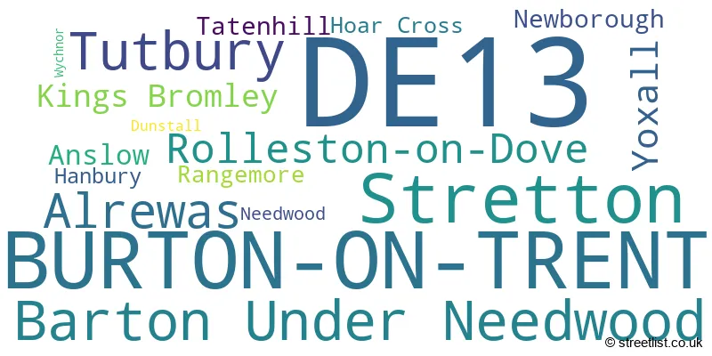
The largest settlement in the DE13 postal code is BURTON-ON-TRENT followed by Stretton, and Barton Under Needwood.
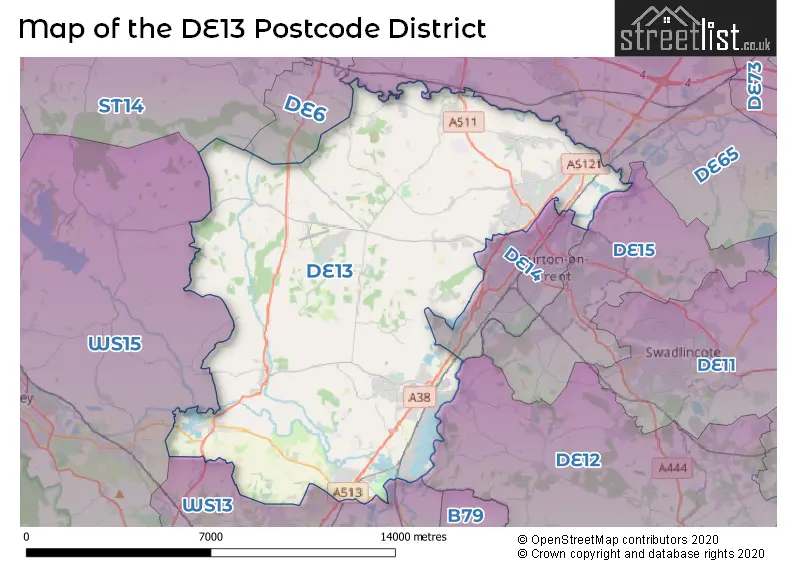
The DE13 Postcode shares a border with DE12 (Measham, Overseal, Moira), DE15 (BURTON-ON-TRENT, Bretby, Drakelow), DE65 (Hilton, Willington, Etwall), WS13 (LICHFIELD, Fradley, Streethay), WS15 (RUGELEY, Brereton, Abbots Bromley) and DE14 (BURTON-ON-TRENT, Branston, Centrum One Hundred).
The primary settlement in the DE13 postcode district is Burton-on-Trent, located in the county of Staffordshire in England. Other significant settlements within this postcode district include Stretton, Alrewas, Kings Bromley, Barton Under Needwood, Dunstall, Hanbury, Hoar Cross, Newborough, Wychnor, Yoxall, Anslow, Needwood, Rangemore, Rolleston-on-Dove, Tatenhill, and Tutbury. The most significant post town in this postcode district is Burton-on-Trent.
For the district DE13, we have data on 4 postcode sectors. Here's a breakdown: The sector DE13 0, covers Burton-On-Trent and Stretton in Staffordshire. The sector DE13 7, covers Alrewas and Kings Bromley in Staffordshire. The sector DE13 8, covers Barton Under Needwood and Yoxall in Staffordshire. The sector DE13 9, covers Tutbury and Rolleston-On-Dove and Burton-On-Trent in Staffordshire.

Map of the DE13 Postcode District
Explore the DE13 postcode district by using our free interactive map.
When it comes to local government, postal geography often disregards political borders. However, for a breakdown in the DE13 District: the district mostly encompasses the East Staffordshire District (B) (858 postcodes), and finally, the Lichfield District area (116 postcodes).
Weather Forecast for DE13
Press Button to Show Forecast for Yoxall
| Time Period | Icon | Description | Temperature | Rain Probability | Wind |
|---|---|---|---|---|---|
| 03:00 to 06:00 | Cloudy | 4.0°C (feels like 2.0°C) | 7.00% | NE 7 mph | |
| 06:00 to 09:00 | Cloudy | 5.0°C (feels like 2.0°C) | 8.00% | NE 9 mph | |
| 09:00 to 12:00 | Overcast | 7.0°C (feels like 4.0°C) | 15.00% | ENE 11 mph | |
| 12:00 to 15:00 | Light rain | 8.0°C (feels like 5.0°C) | 55.00% | ENE 9 mph | |
| 15:00 to 18:00 | Overcast | 9.0°C (feels like 6.0°C) | 14.00% | ENE 11 mph | |
| 18:00 to 21:00 | Overcast | 8.0°C (feels like 5.0°C) | 18.00% | NE 11 mph | |
| 21:00 to 00:00 | Cloudy | 6.0°C (feels like 3.0°C) | 9.00% | NE 11 mph |
Press Button to Show Forecast for Yoxall
| Time Period | Icon | Description | Temperature | Rain Probability | Wind |
|---|---|---|---|---|---|
| 00:00 to 03:00 | Cloudy | 6.0°C (feels like 2.0°C) | 11.00% | NNE 11 mph | |
| 03:00 to 06:00 | Light rain | 5.0°C (feels like 2.0°C) | 45.00% | NNE 11 mph | |
| 06:00 to 09:00 | Light rain | 6.0°C (feels like 2.0°C) | 53.00% | N 11 mph | |
| 09:00 to 12:00 | Heavy rain | 7.0°C (feels like 4.0°C) | 71.00% | NNW 9 mph | |
| 12:00 to 15:00 | Light rain | 9.0°C (feels like 6.0°C) | 49.00% | NW 11 mph | |
| 15:00 to 18:00 | Overcast | 10.0°C (feels like 8.0°C) | 17.00% | WNW 11 mph | |
| 18:00 to 21:00 | Cloudy | 10.0°C (feels like 8.0°C) | 10.00% | W 7 mph | |
| 21:00 to 00:00 | Clear night | 6.0°C (feels like 4.0°C) | 3.00% | SW 7 mph |
Press Button to Show Forecast for Yoxall
| Time Period | Icon | Description | Temperature | Rain Probability | Wind |
|---|---|---|---|---|---|
| 00:00 to 03:00 | Clear night | 5.0°C (feels like 3.0°C) | 1.00% | SW 7 mph | |
| 03:00 to 06:00 | Clear night | 4.0°C (feels like 1.0°C) | 1.00% | SSW 7 mph | |
| 06:00 to 09:00 | Sunny day | 5.0°C (feels like 3.0°C) | 1.00% | S 7 mph | |
| 09:00 to 12:00 | Partly cloudy (day) | 10.0°C (feels like 8.0°C) | 2.00% | S 11 mph | |
| 12:00 to 15:00 | Overcast | 13.0°C (feels like 10.0°C) | 9.00% | S 13 mph | |
| 15:00 to 18:00 | Cloudy | 14.0°C (feels like 11.0°C) | 7.00% | S 13 mph | |
| 18:00 to 21:00 | Partly cloudy (day) | 13.0°C (feels like 10.0°C) | 4.00% | S 11 mph | |
| 21:00 to 00:00 | Clear night | 9.0°C (feels like 7.0°C) | 3.00% | SSE 9 mph |
Press Button to Show Forecast for Yoxall
| Time Period | Icon | Description | Temperature | Rain Probability | Wind |
|---|---|---|---|---|---|
| 00:00 to 03:00 | Clear night | 8.0°C (feels like 5.0°C) | 3.00% | SE 9 mph | |
| 03:00 to 06:00 | Clear night | 7.0°C (feels like 4.0°C) | 2.00% | SE 9 mph | |
| 06:00 to 09:00 | Sunny day | 8.0°C (feels like 5.0°C) | 4.00% | ESE 9 mph | |
| 09:00 to 12:00 | Partly cloudy (day) | 12.0°C (feels like 10.0°C) | 5.00% | ESE 11 mph | |
| 12:00 to 15:00 | Sunny day | 15.0°C (feels like 13.0°C) | 10.00% | SE 13 mph | |
| 15:00 to 18:00 | Partly cloudy (day) | 16.0°C (feels like 13.0°C) | 10.00% | SE 11 mph | |
| 18:00 to 21:00 | Cloudy | 15.0°C (feels like 13.0°C) | 10.00% | ESE 9 mph | |
| 21:00 to 00:00 | Cloudy | 11.0°C (feels like 10.0°C) | 7.00% | ESE 7 mph |
Where is the DE13 Postcode District?
The postcode district DE13 is located in the town of Burton-on-Trent. This town is situated in close proximity to several nearby towns, such as Rugeley, Uttoxeter, Swadlincote, Lichfield, Burntwood, Ashby-de-la-Zouch, and Derby. The distance from Burton-on-Trent to London, the center of the city, is approximately 112.43 miles.
The district is within the post town of BURTON-ON-TRENT.
The sector has postcodes within the nation of England.
The DE13 Postcode District is in the Staffordshire CC region of Shropshire and Staffordshire within the West Midlands (England).
| Postcode Sector | Delivery Office |
|---|---|
| DE13 0 | Burton On Trent Delivery Office |
| DE13 7 | Burton On Trent Delivery Office |
| DE13 8 | Burton On Trent Delivery Office |
| DE13 9 | Burton On Trent Delivery Office |
| D | E | 1 | 3 | - | X | X | X |
| D | E | 1 | 3 | Space | Numeric | Letter | Letter |
Tourist Attractions within the Postcode Area
We found 2 visitor attractions within the DE13 postcode area
| National Memorial Arboretum |
|---|
| Visitor Centres |
| Heritage / Visitor Centre |
| View National Memorial Arboretum on Google Maps |
| Claymills Victorian Pumping Station |
| Historic Properties |
| Other Historic Property |
| View Claymills Victorian Pumping Station on Google Maps |
Current Monthly Rental Prices
| # Bedrooms | Min Price | Max Price | Avg Price |
|---|---|---|---|
| £525 | £737 | £631 | |
| 1 | £155 | £675 | £480 |
| 2 | £675 | £1,200 | £895 |
| 3 | £800 | £1,750 | £1,132 |
| 4 | £1,500 | £1,650 | £1,583 |
| 5 | £585 | £585 | £585 |
Current House Prices
| # Bedrooms | Min Price | Max Price | Avg Price |
|---|---|---|---|
| £180,000 | £1,200,000 | £556,667 | |
| 1 | £70,000 | £235,000 | £147,083 |
| 2 | £65,000 | £475,000 | £223,860 |
| 3 | £70,000 | £950,000 | £328,870 |
| 4 | £175,000 | £1,300,000 | £475,231 |
| 5 | £375,000 | £1,450,000 | £668,648 |
| 6 | £385,000 | £1,975,000 | £960,833 |
| 7 | £1,000,000 | £3,450,000 | £2,050,000 |
| 9 | £47,250 | £47,250 | £47,250 |
Estate Agents who Operate in the DE13 District
| Logo | Name | Brand Name | Address | Contact Number | Total Properties |
|---|---|---|---|---|---|
 | Barton-under-Needwood | Parker Hall | Barton Marina Barton Under Needwood, Burton upon Trent DE13 8DZ | 01283 243746 | 52 |
 | Needwood | Abode | Regents House, 34b High Street, Tutbury Burton on Trent Staffordshire DE13 9LS | 020 3840 3531 | 48 |
 | Burton upon Trent | John German | 129 New Street Burton-Upon-Trent DE14 3QW | 01283 243790 | 38 |
 | Barton Under Needwood | John German | 21 Main Street, Barton Under Needwood, DE13 8AA | 01283 243664 | 35 |
 | Burton on Trent | Newton Fallowell | 36 Station Street Burton on Trent DE14 1AX | 01283 243772 | 32 |
- Alder Moor
- Alrewas
- Anslow
- Anslow Common
- Anslow Gate
- Barton Gate
- Barton Turn
- Barton-under-Needwood
- Burton upon Trent
- Dunstall
- Fauld
- Fradley
- Fradley South
- Hanbury
- Hanbury Woodend
- Hatton
- Hoar Cross
- King's Bromley
- Marchington Woodlands
- Newborough
- Rangemore
- Rolleston on Dove
- Stretton
- Tatenhill
- Tutbury
- Weaverslake
- Woodhouses
- Woodlane
- Wychnor
- Yoxall
| Type of Property | 2018 Average | 2018 Sales | 2017 Average | 2017 Sales | 2016 Average | 2016 Sales | 2015 Average | 2015 Sales |
|---|---|---|---|---|---|---|---|---|
| Detached | £349,681 | 445 | £339,653 | 340 | £327,975 | 388 | £320,937 | 344 |
| Semi-Detached | £203,913 | 283 | £204,198 | 246 | £181,909 | 232 | £182,847 | 243 |
| Terraced | £151,832 | 161 | £155,107 | 118 | £140,647 | 171 | £144,027 | 144 |
| Flats | £253,474 | 59 | £142,266 | 25 | £132,479 | 26 | £87,643 | 28 |