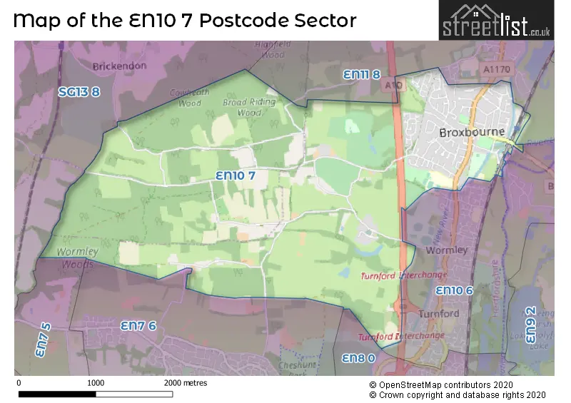
The EN10 7 postcode sector stands on the Essex and Hertfordshire border.
Did you know? According to the 2021 Census, the EN10 7 postcode sector is home to a bustling 6,621 residents!
Given that each sector allows for 400 unique postcode combinations. Letters C, I, K, M, O and V are not allowed in the last two letters of a postcode. With 196 postcodes already in use, this leaves 204 units available.
The EN10 7 postal code covers the settlement of BROXBOURNE.
The EN10 7 Postcode shares a border with SG13 8 (HERTFORD, Bayford, Brickendon), EN7 5 (CHESHUNT , GOFFS OAK , WALTHAM CROSS ), EN7 6 (CHESHUNT , GOFFS OAK ), EN8 0 (CHESHUNT ), EN10 6 (BROXBOURNE, Turnford, Wormley) and EN11 8 (HODDESDON).
The sector is within the post town of BROXBOURNE.
EN10 7 is a postcode sector within the EN1 postcode district which is within the EN Enfield postcode area.
The Royal Mail delivery office for the EN10 7 postal sector is the unknown.
The area of the EN10 7 postcode sector is 4.97 square miles which is 12.87 square kilometres or 3,181.07 square acres.
Waterways within the EN10 7 postcode sector include the New River.

Map of the EN10 7 Postcode Sector
Explore the EN10 7 postcode sector by using our free interactive map.
| E | N | 1 | 0 | - | 7 | X | X |
| E | N | 1 | 0 | Space | 7 | Letter | Letter |
Official List of Streets
BROXBOURNE (94 Streets)
Unofficial Streets or Alternative Spellings
BROXBOURNE
NAZEING NEW ROAD OLD NAZEING ROAD WINFORD DRIVE BEVERLY CLOSE BOARDWALK BOLEYN COURT BREAD AND CHEESE LANE COPTHORNE AVENUE CROWN BRIDGE ELPIN COURT ERMINE STREET GAS WORKS LANE HALLMORES HIGH ROAD BROXBOURNE MC KENZIE ROAD NAZEING OLD ROAD NEW RIVER PATH RICHMOND COURT SHERIDEN WALK SPRING WALK THE ROWANS TURNFORD INTERCHANGE WEST END ROAD WESTCROFT COURT WOOD HOUSE LANEHODDESDON
BENFORD ROAD COCK LANE HIGH STREET THE AVENUEBayford
WHITE STUBBS LANECheshunt
PARK LANE PARADISESchools and Places of Education Within the EN10 7 Postcode Sector
Broxbourne CofE Primary School
Voluntary aided school
Mill Lane, Broxbourne, Hertfordshire, EN10 7AY
Head: Mr Paul Miller
Ofsted Rating: Outstanding
Inspection: 2023-11-16 (201 days ago)
Website: Visit Broxbourne CofE Primary School Website
Phone: 01992462419
Number of Pupils: 244
The Broxbourne School
Academy converter
Badgers Walk, Broxbourne, Hertfordshire, EN10 7FU
Head: Ms Paula Humphreys
Ofsted Rating: Good
Inspection: 2023-04-26 (405 days ago)
Website: Visit The Broxbourne School Website
Phone: 01992411060
Number of Pupils: 1332
House Prices in the EN10 7 Postcode Sector
| Type of Property | 2018 Average | 2018 Sales | 2017 Average | 2017 Sales | 2016 Average | 2016 Sales | 2015 Average | 2015 Sales |
|---|---|---|---|---|---|---|---|---|
| Detached | £821,916 | 32 | £812,309 | 32 | £917,594 | 48 | £737,357 | 49 |
| Semi-Detached | £576,591 | 22 | £585,563 | 16 | £600,673 | 26 | £515,740 | 31 |
| Terraced | £406,950 | 10 | £521,923 | 13 | £425,860 | 18 | £384,499 | 5 |
| Flats | £240,972 | 18 | £260,014 | 50 | £257,380 | 21 | £228,897 | 20 |
Important Postcodes EN10 7 in the Postcode Sector
EN10 7AY is the postcode for Broxbourne C of E Jmi School, Mill Lane, and BROXBOURNE C E PRIMARY SCHOOL, MILL LANE
EN10 7DD is the postcode for 200 BLOCK, The Broxbourne School, High Road, 500 BLOCK, The Broxbourne School, High Road, 800 BLOCK, The Broxbourne School, High Road, The Broxbourne School, High Road, and 100 BLOCK, The Broxbourne School, High Road
| The EN10 7 Sector is within these Local Authorities |
|
|---|---|
| The EN10 7 Sector is within these Counties |
|
| The EN10 7 Sector is within these Water Company Areas |
|
Tourist Attractions within the EN10 7 Postcode Area
We found 1 visitor attractions within the EN1 postcode area
| Priest's House |
|---|
| Historic Properties |
| Historic House / House and Garden / Palace |
| View Priest's House on Google Maps |