The SG13 8 postcode sector is within the county of Hertfordshire.
Did you know? According to the 2021 Census, the SG13 8 postcode sector is home to a bustling 5,992 residents!
Given that each sector allows for 400 unique postcode combinations. Letters C, I, K, M, O and V are not allowed in the last two letters of a postcode. With 205 postcodes already in use, this leaves 195 units available.
The largest settlement in the SG13 8 postal code is HERTFORD followed by Bayford, and Brickendon.
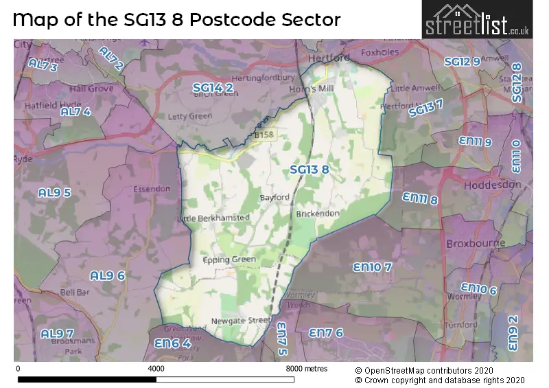
The SG13 8 Postcode shares a border with SG13 7 (HERTFORD, Hertford Heath, Hailey), SG14 1 (HERTFORD), SG14 2 (HERTFORD, Bramfield, Hertingfordbury), EN6 4 (CUFFLEY , NORTHAW , POTTERS BAR ), AL9 6 (Essendon, HATFIELD, BROOKMANS PARK), EN7 5 (CHESHUNT , GOFFS OAK , WALTHAM CROSS ), EN10 7 (BROXBOURNE) and EN11 8 (HODDESDON).
The sector is within the post town of HERTFORD.
SG13 8 is a postcode sector within the SG13 postcode district which is within the SG Stevenage postcode area.
The Royal Mail delivery office for the SG13 8 postal sector is the Hertford Delivery Office.
The area of the SG13 8 postcode sector is 12.31 square miles which is 31.88 square kilometres or 7,878.49 square acres.
Waterways within the SG13 8 postcode sector include the River Lea.

Map of the SG13 8 Postcode Sector
Explore the SG13 8 postcode sector by using our free interactive map.
| S | G | 1 | 3 | - | 8 | X | X |
| S | G | 1 | 3 | Space | 8 | Letter | Letter |
Official List of Streets
HERTFORD (56 Streets)
Bayford (12 Streets)
Brickendon (4 Streets)
Little Berkhamsted (9 Streets)
Epping Green (2 Streets)
Balls Park (3 Streets)
Newgate Street (3 Streets)
Bayfordbury (1 Streets)
Howe Green (1 Streets)
Unofficial Streets or Alternative Spellings
HERTFORD
BROOKSIDE CASTLE STREET WATER LANEHertford Heath
LONDON ROAD BACK LANE BREACH LANE COLE GREEN WAY EVRON CROSSING FOXHOLES ROUNDABOUT (AKA LANCASTER ROUNDABOUT) HOLLY DELL LITTLE BERKHAMSTEAD LANE LONDON ROAD ROUNDABOUT MALTINGS MEWS PEARSONS CLOSE ST MARYS LANE THE GULPHS WALLFIELD ALLEYBROXBOURNE
PEMBRIDGE LANENorthaw
CARBONE HILLCheshunt
DARNICLE HILLEssendon
BEDWELL AVENUE CUCUMBER LANE HORNBEAM LANEHATFIELD
WOODFIELD LANEWeather Forecast for SG13 8
Press Button to Show Forecast for Hertford
| Time Period | Icon | Description | Temperature | Rain Probability | Wind |
|---|---|---|---|---|---|
| 15:00 to 18:00 | Cloudy | 16.0°C (feels like 15.0°C) | 26.00% | SSE 7 mph | |
| 18:00 to 21:00 | Cloudy | 14.0°C (feels like 13.0°C) | 5.00% | SE 7 mph | |
| 21:00 to 00:00 | Partly cloudy (night) | 11.0°C (feels like 10.0°C) | 2.00% | ESE 4 mph |
Press Button to Show Forecast for Hertford
| Time Period | Icon | Description | Temperature | Rain Probability | Wind |
|---|---|---|---|---|---|
| 00:00 to 03:00 | Clear night | 9.0°C (feels like 8.0°C) | 0.00% | ESE 2 mph | |
| 03:00 to 06:00 | Clear night | 7.0°C (feels like 6.0°C) | 1.00% | SSW 2 mph | |
| 06:00 to 09:00 | Sunny day | 9.0°C (feels like 9.0°C) | 0.00% | SSW 2 mph | |
| 09:00 to 12:00 | Sunny day | 14.0°C (feels like 14.0°C) | 1.00% | S 4 mph | |
| 12:00 to 15:00 | Partly cloudy (day) | 17.0°C (feels like 16.0°C) | 2.00% | SSE 4 mph | |
| 15:00 to 18:00 | Cloudy | 18.0°C (feels like 16.0°C) | 4.00% | SE 7 mph | |
| 18:00 to 21:00 | Cloudy | 16.0°C (feels like 15.0°C) | 4.00% | SSE 7 mph | |
| 21:00 to 00:00 | Cloudy | 13.0°C (feels like 12.0°C) | 7.00% | SE 4 mph |
Press Button to Show Forecast for Hertford
| Time Period | Icon | Description | Temperature | Rain Probability | Wind |
|---|---|---|---|---|---|
| 00:00 to 03:00 | Cloudy | 11.0°C (feels like 11.0°C) | 9.00% | E 4 mph | |
| 03:00 to 06:00 | Cloudy | 10.0°C (feels like 10.0°C) | 13.00% | NE 4 mph | |
| 06:00 to 09:00 | Cloudy | 11.0°C (feels like 10.0°C) | 14.00% | NE 4 mph | |
| 09:00 to 12:00 | Cloudy | 13.0°C (feels like 12.0°C) | 15.00% | ENE 7 mph | |
| 12:00 to 15:00 | Cloudy | 15.0°C (feels like 14.0°C) | 18.00% | NE 7 mph | |
| 15:00 to 18:00 | Cloudy | 16.0°C (feels like 14.0°C) | 16.00% | ENE 7 mph | |
| 18:00 to 21:00 | Cloudy | 14.0°C (feels like 13.0°C) | 12.00% | ENE 7 mph | |
| 21:00 to 00:00 | Cloudy | 12.0°C (feels like 11.0°C) | 12.00% | NE 4 mph |
Press Button to Show Forecast for Hertford
| Time Period | Icon | Description | Temperature | Rain Probability | Wind |
|---|---|---|---|---|---|
| 00:00 to 03:00 | Partly cloudy (night) | 10.0°C (feels like 9.0°C) | 6.00% | NNE 4 mph | |
| 03:00 to 06:00 | Clear night | 9.0°C (feels like 8.0°C) | 2.00% | W 4 mph | |
| 06:00 to 09:00 | Sunny day | 10.0°C (feels like 9.0°C) | 2.00% | NNW 7 mph | |
| 09:00 to 12:00 | Sunny day | 14.0°C (feels like 13.0°C) | 2.00% | N 7 mph | |
| 12:00 to 15:00 | Partly cloudy (day) | 17.0°C (feels like 16.0°C) | 6.00% | NNE 7 mph | |
| 15:00 to 18:00 | Cloudy | 18.0°C (feels like 16.0°C) | 14.00% | N 7 mph | |
| 18:00 to 21:00 | Sunny day | 17.0°C (feels like 16.0°C) | 3.00% | NNE 7 mph | |
| 21:00 to 00:00 | Clear night | 12.0°C (feels like 11.0°C) | 1.00% | NE 7 mph |
Press Button to Show Forecast for Hertford
| Time Period | Icon | Description | Temperature | Rain Probability | Wind |
|---|---|---|---|---|---|
| 00:00 to 03:00 | Clear night | 10.0°C (feels like 9.0°C) | 2.00% | NE 4 mph | |
| 03:00 to 06:00 | Cloudy | 9.0°C (feels like 8.0°C) | 6.00% | NNE 4 mph | |
| 06:00 to 09:00 | Cloudy | 10.0°C (feels like 9.0°C) | 7.00% | N 4 mph | |
| 09:00 to 12:00 | Cloudy | 13.0°C (feels like 12.0°C) | 5.00% | NNE 4 mph | |
| 12:00 to 15:00 | Cloudy | 16.0°C (feels like 16.0°C) | 4.00% | NNE 4 mph | |
| 15:00 to 18:00 | Cloudy | 18.0°C (feels like 18.0°C) | 4.00% | NE 4 mph | |
| 18:00 to 21:00 | Cloudy | 18.0°C (feels like 17.0°C) | 4.00% | NE 4 mph | |
| 21:00 to 00:00 | Cloudy | 13.0°C (feels like 12.0°C) | 4.00% | E 4 mph |
Schools and Places of Education Within the SG13 8 Postcode Sector
Abel Smith School
Community school
Churchfields, Hertford, Hertfordshire, SG13 8AE
Head: Mr Daniel Hewitt
Ofsted Rating: Outstanding
Inspection: 2013-11-14 (3824 days ago)
Website: Visit Abel Smith School Website
Phone: 01992583244
Number of Pupils: 228
Bayford Church of England Voluntary Controlled Primary School
Voluntary controlled school
Ashendene Road, Hertford, Hertfordshire, SG13 8PX
Head: Dr Malcom Foster
Ofsted Rating: Good
Inspection: 2019-10-24 (1654 days ago)
Website: Visit Bayford Church of England Voluntary Controlled Primary School Website
Phone: 01992511259
Number of Pupils: 99
Morgans Primary School & Nursery
Community school
Morgans Road, Hertford, Hertfordshire, SG13 8DR
Head: Headteacher Helen Melidoro
Ofsted Rating: Good
Inspection: 2023-12-14 (142 days ago)
Website: Visit Morgans Primary School & Nursery Website
Phone: 01992582162
Number of Pupils: 347
Ponsbourne St Mary's Church of England Primary School
Voluntary controlled school
Newgate Street Village, Hertford, Hertfordshire, SG13 8RA
Head: Mrs Sarah Bridgman
Ofsted Rating: Good
Inspection: 2019-10-10 (1668 days ago)
Website: Visit Ponsbourne St Mary's Church of England Primary School Website
Phone: 01707872395
Number of Pupils: 103
Richard Hale School
Academy converter
Hale Road, Hertford, Hertfordshire, SG13 8EN
Head: Ian Hawkins
Ofsted Rating: Good
Inspection: 2019-12-04 (1613 days ago)
Website: Visit Richard Hale School Website
Phone: 01992583441
Number of Pupils: 1227
Simon Balle All-Through School
Academy converter
Mangrove Road, Hertford, Hertfordshire, SG13 8AJ
Head: Rachel Kirk and Mike Moss
Ofsted Rating: Outstanding
Inspection: 2018-05-10 (2186 days ago)
Website: Visit Simon Balle All-Through School Website
Phone: 01992410400
Number of Pupils: 1597
House Prices in the SG13 8 Postcode Sector
| Type of Property | 2018 Average | 2018 Sales | 2017 Average | 2017 Sales | 2016 Average | 2016 Sales | 2015 Average | 2015 Sales |
|---|---|---|---|---|---|---|---|---|
| Detached | £1,048,225 | 20 | £1,257,990 | 24 | £1,004,776 | 29 | £991,199 | 25 |
| Semi-Detached | £540,676 | 17 | £594,382 | 17 | £514,524 | 17 | £393,523 | 16 |
| Terraced | £455,981 | 27 | £489,276 | 27 | £509,090 | 39 | £454,053 | 48 |
| Flats | £351,858 | 104 | £344,152 | 25 | £393,429 | 14 | £272,323 | 37 |
Important Postcodes SG13 8 in the Postcode Sector
SG13 8AB is the postcode for Royal Mail, Hertford Delivery Office, Greencoates
SG13 8AE is the postcode for Abel Smith J M I School, Churchfields, and Abel Smith School, Churchfields, Greencoates
SG13 8AF is the postcode for Longmore Education Support Centre, Churchfields
SG13 8AJ is the postcode for SWIMMING POOL, Simon Balle School, Mangrove Road, Larch Centre, Simon Balle All Through School, Mangrove Road, SIXTH FORM, Simon Balle School, Mangrove Road, SIX FORM, Simon Balle School, Mangrove Road, KITCHEN/DINING HALL/GYM, Simon Balle School, KITCHEN/DINNING HALL/GYM, Simon Balle School, Mangrove Road, MAIN BLOCK, Simon Balle School, Mangrove Road, Simon Balle School, Mangrove Road, MUSIC BLOCK, Simon Balle School, Mangrove Road, THE LARCH CENTRE, SIMON BALLE ALL-THROUGH SCHOOL, MANGROVE ROAD, and The Larch Centre, Simon Balle School, Mangrove Road
SG13 8DE is the postcode for MAIN BUILDING, Hertfordshire County Council, County Hall,, ARCHIVES AND LOCAL STUDY BUILDING, Hertfordshire County Council, County Hall,, Hertfordshire County Council, County Hall,, LEAHOE HOUSE, Hertfordshire County Council, County Hall,, ARCHIVES AND LOCAL STUDY BUILDING, Hertfordshire County Council, County Hall, and MAIN BUILDING, Hertfordshire County Council, County Hall
SG13 8DR is the postcode for QUEENS, Morgans Primary School, Morgans Road, Morgans Primary School, Morgans Road, and MANDEVILLE, Morgans Primary School, Morgans Road
SG13 8EN is the postcode for NEW BLOCK, Richard Hale School, Hale Road, MAIN BLOCK, Richard Hale School, Hale Road, TECHNOLOGY BLOCK, Richard Hale School, Hale Road, and Richard Hale School, Hale Road
SG13 8EQ is the postcode for East Hertfordshire District Council, Wallfields, Pegs Lane
SG13 8FL is the postcode for Hertfordshire Constabulary, Hertford Police Station, Hale Road
SG13 8LD is the postcode for University of Hertfordshire, Bayfordbury, Lower Hatfield Road, and SCIENCE BUILDING, University of Hertfordshire, Bayfordbury, Lower Hatfield Road
SG13 8PX is the postcode for Bayford (C of E) VC Primary School, Ashendene Road, and Bayford (C of E) VC Primary School, Ashendene Road, Bayford
| The SG13 8 Sector is within these Local Authorities |
|
|---|---|
| The SG13 8 Sector is within these Counties |
|
| The SG13 8 Sector is within these Water Company Areas |
|