The HP14 4 postcode sector stands on the Buckinghamshire and Oxfordshire border.
Did you know? According to the 2021 Census, the HP14 4 postcode sector is home to a bustling 8,002 residents!
Given that each sector allows for 400 unique postcode combinations. Letters C, I, K, M, O and V are not allowed in the last two letters of a postcode. With 221 postcodes already in use, this leaves 179 units available.
The largest settlement in the HP14 4 postal code is Walters Ash followed by Naphill, and Hughenden Valley.
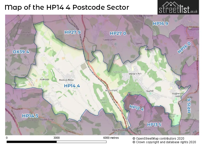
The HP14 4 Postcode shares a border with HP27 0 (PRINCES RISBOROUGH, Lacey Green, Speen), HP27 9 (PRINCES RISBOROUGH, Longwick, Bledlow), OX39 4 (CHINNOR, Kingston Blount, Sydenham), HP12 4 (HIGH WYCOMBE, Sands Industrial Estate), HP13 5 (HIGH WYCOMBE, Downley), HP14 3 (Stokenchurch, Lane End, Piddington), HP15 6 (Holmer Green, Great Kingshill, Widmer End) and HP16 0 (Prestwood, GREAT MISSENDEN, Little Kingshill).
The sector is within the post town of HIGH WYCOMBE.
HP14 4 is a postcode sector within the HP14 postcode district which is within the HP Hemel Hempstead postcode area.
The Royal Mail delivery office for the HP14 4 postal sector is the High Wycombe South Postal Delivery Office.
The area of the HP14 4 postcode sector is 12.50 square miles which is 32.37 square kilometres or 8,000.01 square acres.

Map of the HP14 4 Postcode Sector
Explore the HP14 4 postcode sector by using our free interactive map.
| H | P | 1 | 4 | - | 4 | X | X |
| H | P | 1 | 4 | Space | 4 | Letter | Letter |
Official List of Streets
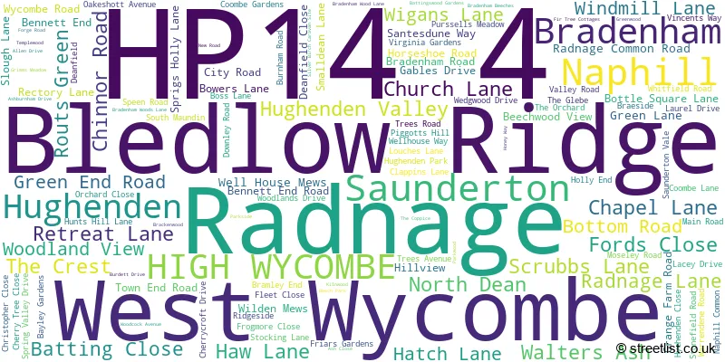
Walters Ash (21 Streets)
Bledlow Ridge (15 Streets)
Naphill (31 Streets)
Saunderton (13 Streets)
Radnage (16 Streets)
Hughenden Valley (19 Streets)
West Wycombe (2 Streets)
North Dean (3 Streets)
Hughenden (1 Streets)
Bradenham (1 Streets)
Unofficial Streets or Alternative Spellings
Great Kingshill
HATCHES LANE BATTINGS WOOD GARDENS BOOT LANE CHILTERN VIEW CHURCH FARM COLLIERS LANE GRANGE HILL ROAD HITCHENDEN FARM ORCHARD FARM PERRY LANE RIDGE SIDE SPRING RISING SPRINT RISING SUNKEN LANE THE CITY THE COMMON WEDGEWOOD DRIVE WILLOW COURTPrestwood
HAMPDEN ROADSpeen
CHAPEL HILL SPRING COPPICE LANEGREAT MISSENDEN
BRYANTS BOTTOM ROADLacey Green
SLAD LANE SMALLDEAN LANECryers Hill
CRYERS HILL ROADCHINNOR
CHINNOR HILL SPRIGS HOLLYSchools and Places of Education Within the HP14 4 Postcode Sector
Bledlow Ridge School
Community school
Church Lane, High Wycombe, Buckinghamshire, HP14 4AZ
Head: Mrs Natasha Harrison
Ofsted Rating: Good
Inspection: 2023-11-22 (193 days ago)
Website: Visit Bledlow Ridge School Website
Phone: 01494481253
Number of Pupils: 172
Hughenden Primary School
Community school
Spring Valley Drive, High Wycombe, Buckinghamshire, HP14 4LR
Head: Mrs Katherine Mann
Ofsted Rating: Good
Inspection: 2022-05-18 (746 days ago)
Website: Visit Hughenden Primary School Website
Phone: 01494562501
Number of Pupils: 175
Naphill and Walters Ash School
Community school
Kilnwood, High Wycombe, Buckinghamshire, HP14 4UL
Head: Kerenza Gwynn
Ofsted Rating: Good
Inspection: 2023-05-11 (388 days ago)
Website: Visit Naphill and Walters Ash School Website
Phone: 01494562813
Number of Pupils: 323
Radnage Church of England Primary School
Voluntary aided school
City Road, High Wycombe, Buckinghamshire, HP14 4DW
Head: Mr Sam Browne
Ofsted Rating: Good
Inspection: 2019-05-01 (1859 days ago)
Website: Visit Radnage Church of England Primary School Website
Phone: 01494482167
Number of Pupils: 85
House Prices in the HP14 4 Postcode Sector
| Type of Property | 2018 Average | 2018 Sales | 2017 Average | 2017 Sales | 2016 Average | 2016 Sales | 2015 Average | 2015 Sales |
|---|---|---|---|---|---|---|---|---|
| Detached | £695,073 | 48 | £729,359 | 54 | £677,317 | 41 | £582,671 | 68 |
| Semi-Detached | £488,194 | 31 | £389,894 | 47 | £402,871 | 42 | £387,723 | 34 |
| Terraced | £422,556 | 9 | £313,341 | 22 | £340,373 | 16 | £331,513 | 19 |
| Flats | £205,500 | 4 | £160,000 | 3 | £153,625 | 8 | £153,000 | 2 |
Important Postcodes HP14 4 in the Postcode Sector
HP14 4AZ is the postcode for Bledlow Ridge School, Church Lane
HP14 4DW is the postcode for Radnage C of E First School, City Road
HP14 4LG is the postcode for Hughenden Valley Surgery, Valley Road
HP14 4LR is the postcode for Hughenden Primary School, Spring Valley Drive, Hughenden Valley, MAIN BUILDING, Hughenden Primary School, Spring Valley Drive, and Hughenden Primary School, Spring Valley Drive
HP14 4UE is the postcode for E BLOCK, Royal Air Force, Naphill
HP14 4UL is the postcode for Naphill & Walters Ash School, Walters Ash, NAPHILL AND WALTERS ASH SCHOOL, KILNWOOD, WALTERS ASH, and Naphill And Walters Ash School, Kilnwood
| The HP14 4 Sector is within these Local Authorities |
|
|---|---|
| The HP14 4 Sector is within these Counties |
|
| The HP14 4 Sector is within these Water Company Areas |
|
Tourist Attractions within the HP14 4 Postcode Area
We found 1 visitor attractions within the HP14 postcode area
| Hughenden Manor |
|---|
| Historic Properties |
| Historic House / House and Garden / Palace |
| View Hughenden Manor on Google Maps |