The HU7 postcode district is a postal district located in the HU Hull postcode area with a population of 47,875 residents according to the 2021 England and Wales Census.
The area of the HU7 postcode district is 9.82 square miles which is 25.43 square kilometres or 6,283.78 acres.
Currently, the HU7 district has about 730 postcode units spread across 5 geographic postcode sectors.
Given that each sector allows for 400 unique postcode combinations, the district has a capacity of 2,000 postcodes. With 730 postcodes already in use, this leaves 1270 units available.
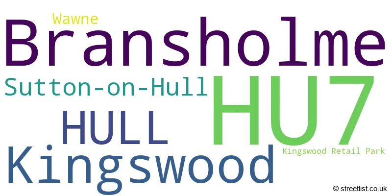
The largest settlement in the HU7 postal code is Bransholme followed by Kingswood, and HULL.
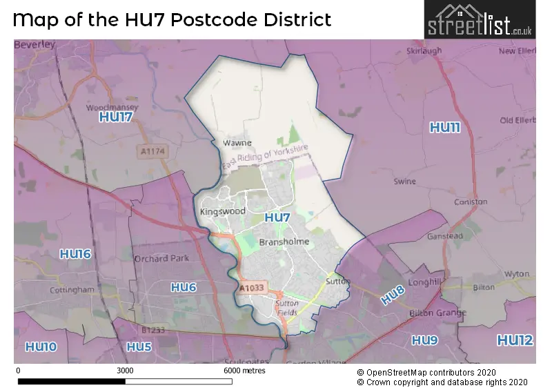
The HU7 Postcode shares a border with HU17 (BEVERLEY, Leven, Walkington), HU6 (HULL, Dunswell), HU8 (HULL, Garden Village) and HU11 (Bilton, Aldbrough, Sproatley).
The primary settlement in the HU7 postcode district is Kingswood, located in Hull, in the East Riding of Yorkshire. Other significant settlements include Bransholme, Sutton-on-Hull, and Wawne. The main post town in this district is Hull, which is located in the East Riding of Yorkshire, England.
For the district HU7, we have data on 6 postcode sectors. Here's a breakdown: The sector HU7 0, covers Hull in East Riding of Yorkshire. The sector HU7 3, covers Kingswood in East Riding of Yorkshire. The sector HU7 4, covers Bransholme and Sutton-On-Hull and Hull in East Riding of Yorkshire. The sector HU7 5, covers Bransholme and Wawne in East Riding of Yorkshire. The sector HU7 6, covers Bransholme and Hull in East Riding of Yorkshire. The sector HU7 9 is non-geographic. It's often designated for PO Boxes, large organisations, or special services.

Map of the HU7 Postcode District
Explore the HU7 postcode district by using our free interactive map.
When it comes to local government, postal geography often disregards political borders. However, for a breakdown in the HU7 District: the district mostly encompasses the City of Kingston upon Hull (B) (728 postcodes), and finally, the East Riding of Yorkshire area (25 postcodes).
Recent House Sales in HU7
| Date | Price | Address |
|---|---|---|
| 17/10/2023 | £130,000 | Shilling Close, Kingswood, Hull, HU7 3LE |
| 29/09/2023 | £140,000 | Glebe Farm, Wawne, Hull, HU7 5UZ |
| 29/09/2023 | £169,000 | Brockwell Park, Kingswood, Hull, HU7 3FH |
| 22/09/2023 | £140,000 | Viola Close, Kingswood, Hull, HU7 3FU |
| 19/09/2023 | £71,000 | Bridport Close, Bransholme, Hull, HU7 6AQ |
| 15/09/2023 | £105,000 | Potterill Lane, Sutton On Hull, Hull, HU7 4TF |
| 08/09/2023 | £147,500 | Robinswood Drive, Bransholme, Hull, HU7 4ZD |
| 08/09/2023 | £63,000 | Cheriton Close, Bransholme, Hull, HU7 4HP |
| 05/09/2023 | £71,000 | Enstone Garth, Bransholme, Hull, HU7 4LF |
| 04/09/2023 | £90,000 | Grimscott Close, Bransholme, Hull, HU7 4ET |
Weather Forecast for HU7
Press Button to Show Forecast for Bransholme
| Time Period | Icon | Description | Temperature | Rain Probability | Wind |
|---|---|---|---|---|---|
| 06:00 to 09:00 | Cloudy | 3.0°C (feels like 1.0°C) | 5.00% | N 4 mph | |
| 09:00 to 12:00 | Cloudy | 7.0°C (feels like 5.0°C) | 6.00% | NE 7 mph | |
| 12:00 to 15:00 | Light rain | 9.0°C (feels like 7.0°C) | 44.00% | NE 7 mph | |
| 15:00 to 18:00 | Cloudy | 9.0°C (feels like 7.0°C) | 12.00% | E 7 mph | |
| 18:00 to 21:00 | Cloudy | 8.0°C (feels like 6.0°C) | 6.00% | E 7 mph | |
| 21:00 to 00:00 | Clear night | 4.0°C (feels like 2.0°C) | 2.00% | E 7 mph |
Press Button to Show Forecast for Bransholme
| Time Period | Icon | Description | Temperature | Rain Probability | Wind |
|---|---|---|---|---|---|
| 00:00 to 03:00 | Partly cloudy (night) | 4.0°C (feels like 2.0°C) | 3.00% | ENE 4 mph | |
| 03:00 to 06:00 | Cloudy | 3.0°C (feels like 1.0°C) | 9.00% | NE 4 mph | |
| 06:00 to 09:00 | Partly cloudy (day) | 5.0°C (feels like 3.0°C) | 7.00% | ENE 4 mph | |
| 09:00 to 12:00 | Cloudy | 9.0°C (feels like 6.0°C) | 10.00% | E 9 mph | |
| 12:00 to 15:00 | Cloudy | 10.0°C (feels like 7.0°C) | 14.00% | E 11 mph | |
| 15:00 to 18:00 | Cloudy | 10.0°C (feels like 8.0°C) | 15.00% | ENE 11 mph | |
| 18:00 to 21:00 | Cloudy | 9.0°C (feels like 6.0°C) | 12.00% | ENE 11 mph | |
| 21:00 to 00:00 | Cloudy | 8.0°C (feels like 5.0°C) | 11.00% | NE 9 mph |
Press Button to Show Forecast for Bransholme
| Time Period | Icon | Description | Temperature | Rain Probability | Wind |
|---|---|---|---|---|---|
| 00:00 to 03:00 | Cloudy | 8.0°C (feels like 5.0°C) | 16.00% | NE 11 mph | |
| 03:00 to 06:00 | Light rain | 8.0°C (feels like 4.0°C) | 52.00% | NE 13 mph | |
| 06:00 to 09:00 | Heavy rain | 8.0°C (feels like 5.0°C) | 78.00% | NE 13 mph | |
| 09:00 to 12:00 | Heavy rain | 10.0°C (feels like 7.0°C) | 79.00% | ENE 16 mph | |
| 12:00 to 15:00 | Light rain shower (day) | 11.0°C (feels like 8.0°C) | 41.00% | ENE 13 mph | |
| 15:00 to 18:00 | Light rain shower (day) | 10.0°C (feels like 7.0°C) | 55.00% | NE 13 mph | |
| 18:00 to 21:00 | Light rain | 9.0°C (feels like 7.0°C) | 52.00% | NE 11 mph | |
| 21:00 to 00:00 | Partly cloudy (night) | 8.0°C (feels like 6.0°C) | 7.00% | S 9 mph |
Where is the HU7 Postcode District?
The data suggests that the postcode district HU7 is located in HULL. HULL is surrounded by several nearby towns, including Cottingham to the west (3.77 miles away), Beverley to the northwest (4.91 miles away), Hessle to the southwest (7.09 miles away), Barrow-Upon-Humber to the south (9.36 miles away), and Hornsea to the northeast (9.71 miles away). Additionally, HU7 is approximately 159.05 miles away from the center of London.
The district is within the post town of HULL.
The sector has postcodes within the nation of England.
The HU7 Postcode District is covers the following regions.
- Kingston upon Hull, City of - East Yorkshire and Northern Lincolnshire - Yorkshire and The Humber
- East Riding of Yorkshire - East Yorkshire and Northern Lincolnshire - Yorkshire and The Humber
| Postcode Sector | Delivery Office |
|---|---|
| HU7 0 | Malmo Road Delivery Office |
| HU7 3 | Malmo Road Delivery Office |
| HU7 4 | Malmo Road Delivery Office |
| HU7 5 | Malmo Road Delivery Office |
| HU7 6 | Malmo Road Delivery Office |
| H | U | 7 | - | X | X | X |
| H | U | 7 | Space | Numeric | Letter | Letter |
Current Monthly Rental Prices
| # Bedrooms | Min Price | Max Price | Avg Price |
|---|---|---|---|
| 1 | £550 | £550 | £550 |
| 2 | £525 | £750 | £658 |
| 3 | £650 | £895 | £785 |
| 4 | £675 | £825 | £742 |
| 5 | £1,250 | £1,250 | £1,250 |
Current House Prices
| # Bedrooms | Min Price | Max Price | Avg Price |
|---|---|---|---|
| £200,000 | £1,750,000 | £975,000 | |
| 1 | £45,000 | £150,000 | £100,000 |
| 2 | £60,000 | £330,000 | £130,497 |
| 3 | £60,000 | £345,000 | £173,840 |
| 4 | £85,000 | £390,000 | £256,529 |
| 5 | £250,000 | £420,000 | £326,250 |
| 6 | £365,000 | £365,000 | £365,000 |
Estate Agents who Operate in the HU7 District
| Logo | Name | Brand Name | Address | Contact Number | Total Properties |
|---|---|---|---|---|---|
 | Kingswood | Beercocks | 16 Village Green Way, Kingswood, Hull, HU7 3DR | 01482 425106 | 43 |
 | Hull | Symonds & Greenham | 412 Cottingham Road, Hull, HU6 8QE | 01482 444200 | 27 |
 | Hull | Reeds Rains | 508 Holderness Road, Hull, HU9 3DS | 01482 251835 | 25 |
 | Sutton-on-Hull | Whitakers | 86 Church Street, Sutton-On-Hull, Hull, HU7 4TD | 01482 251726 | 21 |
 | Hull | Zest | 626 James Reckitt Avenue, Hull, HU8 0LG | 01482 216070 | 15 |
| Type of Property | 2018 Average | 2018 Sales | 2017 Average | 2017 Sales | 2016 Average | 2016 Sales | 2015 Average | 2015 Sales |
|---|---|---|---|---|---|---|---|---|
| Detached | £215,579 | 177 | £217,872 | 177 | £203,751 | 191 | £193,455 | 214 |
| Semi-Detached | £137,174 | 324 | £129,496 | 241 | £125,142 | 199 | £117,709 | 225 |
| Terraced | £116,406 | 330 | £105,810 | 351 | £103,159 | 279 | £97,394 | 358 |
| Flats | £82,923 | 34 | £81,121 | 28 | £86,698 | 21 | £83,789 | 29 |