
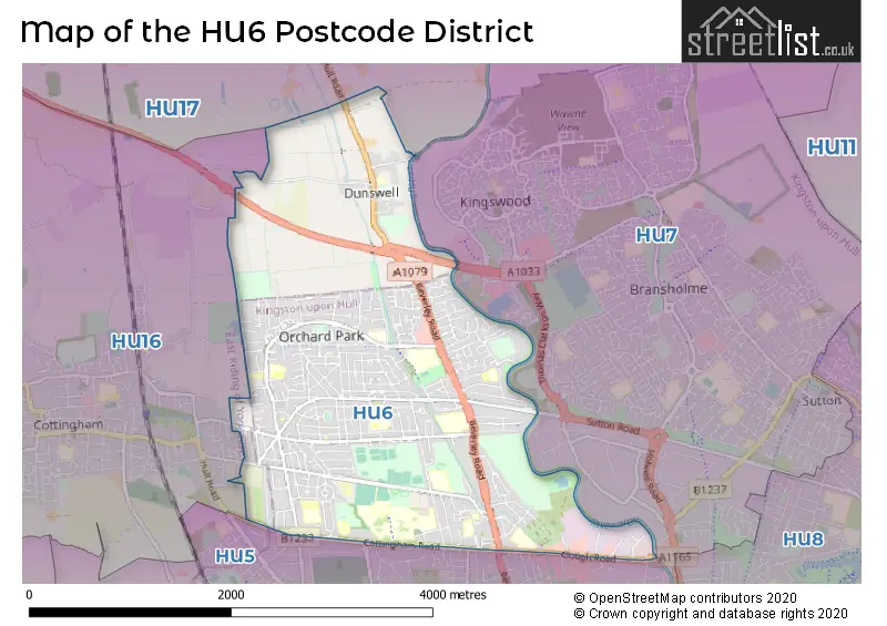
Map of the Postcode District
Explore the postcode district by using our interactive map.
Circles represent recorded crime; the larger the circle, the higher the crime rates.
Your support helps keep this site running!
If you enjoy using this website, consider buying me a coffee to help cover hosting costs.
The postcode district located in the HU Hull postal area , HU6 has a population of 36,013 residents according to the 2021 England and Wales Census.
The area of the district is 4.10 square miles (10.61 square kilometers or 2,622.39 acres).
Where is the HU6 District?
To give you an idea where the district is located we have created the following table showing nearby towns.
Nearest Towns to HU6
| Town | Distance (miles) | Direction |
|---|---|---|
| Cottingham | 1.79 | W |
| Kingston upon Hull | 3.22 | SSE |
| Beverley | 4.77 | NNW |
| Hessle | 5.05 | SSW |
| Barton-upon-Humber | 7.50 | SSW |
| Hedon | 7.73 | ESE |
| South Cave | 9.47 | W |
| Hornsea | 12.10 | NE |
| Winterton | 12.96 | SW |
| Market Weighton | 13.36 | WNW |
| Immingham | 13.44 | SSE |
| Driffield | 15.50 | N |
| Brigg | 16.82 | SSW |
| Withernsea | 16.90 | ESE |
| Scunthorpe | 17.53 | SW |
| Grimsby | 19.25 | SE |
| Pocklington | 19.46 | WNW |
| Howden | 20.55 | W |
| Cleethorpes | 20.89 | SE |
| Goole | 21.28 | WSW |
The post town for this district is HULL.
Postcode Information for District HU6 (Total Geographical Postcodes: 1299)
| Location | Post Town | Sector | Number of Postcodes |
|---|---|---|---|
| HULL | HULL | HU6 7 | 447 |
| HULL | HULL | HU6 8 | 423 |
| HULL | HULL | HU6 9 | 413 |
| Dunswell | HULL | HU6 0 | 16 |
Retail and Shopping in HU6
Street
Town
Locality
Number of Shops
Central Postcode
View on Google Maps
COTTINGHAM ROAD
HULL
38
HU6 7SD
View on Google Maps
ENDIKE LANE
HULL
33
HU6 8AG
View on Google Maps
BEVERLEY ROAD
HULL
31
HU6 7EY
View on Google Maps
GREENWOOD AVENUE
HULL
28
HU6 9RY
View on Google Maps
INGLEMIRE LANE
HULL
15
HU6 8JL
View on Google Maps
ELLERBURN AVENUE
HULL
12
HU6 9RR
View on Google Maps
CLOUGH ROAD
HULL
10
HU6 7PT
View on Google Maps
ORCHARD PARK ROAD
HULL
9
HU6 9BX
View on Google Maps
THE QUADRANT
HULL
6
HU6 8NS
View on Google Maps
| Street | Town | Locality | Number of Shops | Central Postcode | View on Google Maps |
|---|---|---|---|---|---|
| COTTINGHAM ROAD | HULL | 38 | HU6 7SD | View on Google Maps | |
| ENDIKE LANE | HULL | 33 | HU6 8AG | View on Google Maps | |
| BEVERLEY ROAD | HULL | 31 | HU6 7EY | View on Google Maps | |
| GREENWOOD AVENUE | HULL | 28 | HU6 9RY | View on Google Maps | |
| INGLEMIRE LANE | HULL | 15 | HU6 8JL | View on Google Maps | |
| ELLERBURN AVENUE | HULL | 12 | HU6 9RR | View on Google Maps | |
| CLOUGH ROAD | HULL | 10 | HU6 7PT | View on Google Maps | |
| ORCHARD PARK ROAD | HULL | 9 | HU6 9BX | View on Google Maps | |
| THE QUADRANT | HULL | 6 | HU6 8NS | View on Google Maps |
The primary settlement in the HU6 postcode district is Dunswell. It is located in the county of East Riding of Yorkshire in England. The most significant post town in this postcode district is Hull.
When it comes to local government, postal geography often disregards political borders. However, this district intersects the following councils: the district mostly encompasses the City of Kingston upon Hull (B) (619 postal codes), and finally, the East Riding of Yorkshire area (41 postal codes).
The largest settlements in the HU6 postal code are HULL and Dunswell.
The HU6 Postcode shares a border with HU16 (COTTINGHAM, Skidby, Raywell), HU17 (BEVERLEY, Leven, Walkington), HU5 (HULL) and HU7 (Bransholme, Kingswood, HULL).


Schools in the Sector
Dunswell Primary School
Phase: Primary
Address: Beverley Road , Dunswell , Hull
Postcode: HU6 0AD
Headteacher: Mrs Catherine Burrell / Alison Oxtoby (Co-Heads) (Executive Head Teacher)
Ofsted Rating: Good
Parkstone Primary School
Phase: Primary
Address: Parkstone Road , Hull
Postcode: HU6 7DE
Headteacher: Mrs Sarah Waller (Headteacher)
Ofsted Rating: Good
Parkstone Primary School
Phase: Primary
Address: Parkstone Road , Hull
Postcode: HU6 7DE
Headteacher: Mrs Sarah WALLER (Headteacher)
Ofsted Rating: Good
Newland St John's Church of England Academy
Phase: Primary
Address: Beresford Avenue , Hull
Postcode: HU6 7LS
Headteacher: Mrs Elisabeth Brett (Headteacher)
Ofsted Rating: Good
St Nicholas Primary School
Phase: Primary
Address: Cottingham Road , Kingston-upon-Hull
Postcode: HU6 7RH
Headteacher: Mrs Sarah Waller (Headteacher)
Ofsted Rating: Good
Newland School for Girls
Phase: Secondary
Address: Cottingham Road , Hull
Postcode: HU6 7RU
Headteacher: Ms Vicky Callaghan (Headteacher)
Ofsted Rating: Requires improvement
Newland School for Girls
Phase: Secondary
Address: Cottingham Road , Hull
Postcode: HU6 7RU
Headteacher: Ms Vicky Callaghan (Headteacher)
Ofsted Rating: Good
University of Hull
Phase: Not applicable
Address: Cottingham Road , Kingston-upon-Hull
Postcode: HU6 7RX
Headteacher: Professor Susan Lea (Vice-Chancellor)
Ofsted Rating: Requires improvement
Endsleigh Holy Child VC Academy
Phase: Primary
Address: Inglemire Avenue , Hull
Postcode: HU6 7TE
Headteacher: Mrs Angela Spencer (Executive Headteacher)
Ofsted Rating: Good
St Mary's College
Phase: Secondary
Address: Cranbrook Avenue , Hull
Postcode: HU6 7TN
Headteacher: Mr Ged Fitzpatrick (Headteacher)
Ofsted Rating: Outstanding
St Mary's College, Voluntary Catholic Academy
Phase: Secondary
Address: Cranbrook Avenue , Hull
Postcode: HU6 7TN
Headteacher: Mrs Maria Stead (Headteacher)
Ofsted Rating: Outstanding
Endike Academy
Phase: Primary
Address: Endike Lane , Hull
Postcode: HU6 7UR
Headteacher: Miss Natalie Morris ()
Ofsted Rating: Good
The Green Way Academy
Phase: Primary
Address: 21st Avenue , Hull
Postcode: HU6 8HD
Headteacher: Mr Simon Bush (Headteacher)
Ofsted Rating: Good
McMillan Nursery School
Phase: Nursery
Address: Eleventh Avenue , Kingston-upon-Hull
Postcode: HU6 8HT
Headteacher: Mr Simon Bush (Headteacher)
Ofsted Rating: Good
Frederick Holmes School
Phase: Not applicable
Address: Inglemire Lane , Hull
Postcode: HU6 8JJ
Headteacher: Mrs Barbara Ribey (Headteacher)
Ofsted Rating: Good
Frederick Holmes School
Phase: Not applicable
Address: Inglemire Lane , Hull
Postcode: HU6 8JJ
Headteacher: Mrs Helen Maddison (Headteacher)
Ofsted Rating: Good
Hall Road Academy
Phase: Primary
Address: Hall Road , Hull
Postcode: HU6 8PP
Headteacher: Mr Luke Pinder (Headteacher)
Ofsted Rating: Good
St Anthony's Catholic Primary School
Phase: Primary
Address: Dane Park Road , Hull
Postcode: HU6 9AA
Headteacher: Ms Nina Curran (Acting Headteacher)
Ofsted Rating: Good
St Anthony's Voluntary Catholic Academy
Phase: Primary
Address: Dane Park Road , Hull
Postcode: HU6 9AA
Headteacher: Mrs Jessica Storch (Headteacher)
Ofsted Rating: Good
Sirius Academy North
Phase: Secondary
Address: 540 Hall Road , Hull
Postcode: HU6 9BP
Headteacher: Mr Ian Ravenscroft ()
Ofsted Rating: Good
Thorpepark Academy
Phase: Primary
Address: Laxthorpe , Orchard Park Estate , Hull
Postcode: HU6 9EG
Headteacher: Caroline Knight (Executive Headteacher)
Ofsted Rating: Good
The Parks Primary Academy
Phase: Primary
Address: Courtway Road , Hull
Postcode: HU6 9TA
Headteacher: Mr Michael McGrath ()
Ofsted Rating: Outstanding
Stations in the Sector
No stations found in this postcode district.
Accessable Motorway Junctions
M62 J38
Average Driving Time from within the district: 23.40
Average Driving Distance: 17.84
Number of Postcodes that can access the Motorway Junction: 661
M180 J5
Average Driving Time from within the district: 24.68
Average Driving Distance: 17.30
Number of Postcodes that can access the Motorway Junction: 661
M180 J4
Average Driving Time from within the district: 30.84
Average Driving Distance: 23.69
Number of Postcodes that can access the Motorway Junction: 661
M62 J37
Average Driving Time from within the district: 31.08
Average Driving Distance: 26.01
Number of Postcodes that can access the Motorway Junction: 661
M180 J3
Average Driving Time from within the district: 40.85
Average Driving Distance: 33.95
Number of Postcodes that can access the Motorway Junction: 661
Weather Forecast for Newland
| Time Period | Icon | Description | Temperature | Rain Probability | Wind |
|---|---|---|---|---|---|
| 12:00 to 15:00 | Partly cloudy (day) | 14.0°C (feels like 12.0°C) | 1.00% | W 11 mph | |
| 15:00 to 18:00 | Sunny day | 14.0°C (feels like 13.0°C) | 0.00% | W 9 mph | |
| 18:00 to 21:00 | Clear night | 11.0°C (feels like 10.0°C) | 0.00% | WSW 4 mph | |
| 21:00 to 00:00 | Clear night | 9.0°C (feels like 8.0°C) | 0.00% | SW 4 mph |
| Time Period | Icon | Description | Temperature | Rain Probability | Wind |
|---|---|---|---|---|---|
| 00:00 to 03:00 | Clear night | 8.0°C (feels like 7.0°C) | 0.00% | SW 4 mph | |
| 03:00 to 06:00 | Clear night | 8.0°C (feels like 6.0°C) | 0.00% | SSW 7 mph | |
| 06:00 to 09:00 | Clear night | 8.0°C (feels like 6.0°C) | 0.00% | SSW 7 mph | |
| 09:00 to 12:00 | Cloudy | 10.0°C (feels like 7.0°C) | 4.00% | SW 9 mph | |
| 12:00 to 15:00 | Overcast | 13.0°C (feels like 11.0°C) | 6.00% | SSW 11 mph | |
| 15:00 to 18:00 | Cloudy | 14.0°C (feels like 12.0°C) | 3.00% | SSW 11 mph | |
| 18:00 to 21:00 | Clear night | 12.0°C (feels like 10.0°C) | 1.00% | S 9 mph | |
| 21:00 to 00:00 | Partly cloudy (night) | 12.0°C (feels like 9.0°C) | 1.00% | S 11 mph |
| Time Period | Icon | Description | Temperature | Rain Probability | Wind |
|---|---|---|---|---|---|
| 00:00 to 03:00 | Clear night | 11.0°C (feels like 8.0°C) | 1.00% | S 11 mph | |
| 03:00 to 06:00 | Clear night | 10.0°C (feels like 7.0°C) | 2.00% | S 11 mph | |
| 06:00 to 09:00 | Clear night | 10.0°C (feels like 7.0°C) | 1.00% | SSE 13 mph | |
| 09:00 to 12:00 | Sunny day | 11.0°C (feels like 9.0°C) | 1.00% | SSE 13 mph | |
| 12:00 to 15:00 | Partly cloudy (day) | 14.0°C (feels like 11.0°C) | 0.00% | S 18 mph | |
| 15:00 to 18:00 | Partly cloudy (day) | 15.0°C (feels like 12.0°C) | 1.00% | S 13 mph | |
| 18:00 to 21:00 | Clear night | 14.0°C (feels like 11.0°C) | 1.00% | SSE 13 mph | |
| 21:00 to 00:00 | Clear night | 13.0°C (feels like 11.0°C) | 3.00% | SSE 13 mph |
| Time Period | Icon | Description | Temperature | Rain Probability | Wind |
|---|---|---|---|---|---|
| 00:00 to 03:00 | Partly cloudy (night) | 13.0°C (feels like 10.0°C) | 13.00% | SSE 13 mph | |
| 03:00 to 06:00 | Partly cloudy (night) | 13.0°C (feels like 11.0°C) | 14.00% | S 13 mph | |
| 06:00 to 09:00 | Cloudy | 12.0°C (feels like 10.0°C) | 13.00% | S 13 mph | |
| 09:00 to 12:00 | Cloudy | 13.0°C (feels like 11.0°C) | 10.00% | S 11 mph | |
| 12:00 to 15:00 | Cloudy | 14.0°C (feels like 11.0°C) | 12.00% | SSW 13 mph | |
| 15:00 to 18:00 | Partly cloudy (day) | 13.0°C (feels like 11.0°C) | 12.00% | S 11 mph | |
| 18:00 to 21:00 | Clear night | 11.0°C (feels like 9.0°C) | 6.00% | S 11 mph | |
| 21:00 to 00:00 | Clear night | 10.0°C (feels like 7.0°C) | 3.00% | SSW 11 mph |
| Time Period | Icon | Description | Temperature | Rain Probability | Wind |
|---|---|---|---|---|---|
| 00:00 to 03:00 | Partly cloudy (night) | 9.0°C (feels like 6.0°C) | 7.00% | SSW 11 mph | |
| 03:00 to 06:00 | Clear night | 9.0°C (feels like 6.0°C) | 4.00% | SSW 13 mph | |
| 06:00 to 09:00 | Partly cloudy (night) | 8.0°C (feels like 5.0°C) | 6.00% | SSW 13 mph | |
| 09:00 to 12:00 | Partly cloudy (day) | 10.0°C (feels like 7.0°C) | 6.00% | SSW 16 mph | |
| 12:00 to 15:00 | Cloudy | 12.0°C (feels like 9.0°C) | 10.00% | SW 16 mph | |
| 15:00 to 18:00 | Cloudy | 12.0°C (feels like 10.0°C) | 11.00% | SW 16 mph | |
| 18:00 to 21:00 | Clear night | 11.0°C (feels like 8.0°C) | 7.00% | SW 13 mph | |
| 21:00 to 00:00 | Clear night | 10.0°C (feels like 7.0°C) | 4.00% | SW 13 mph |
| Postal Sector | Delivery Office |
|---|---|
| HU6 0 | Malmo Road Delivery Office |
| HU6 7 | Malmo Road Delivery Office |
| HU6 8 | Malmo Road Delivery Office |
| HU6 9 | Malmo Road Delivery Office |
| H | U | 6 | - | X | X | X |
| H | U | 6 | Space | Numeric | Letter | Letter |
Street List for the HU6 District
Current Monthly Rental Prices
| # Bedrooms | Min Price | Max Price | Avg Price |
|---|---|---|---|
| 1 | £295 | £719 | £449 |
| 2 | £400 | £1,199 | £695 |
| 3 | £498 | £2,000 | £948 |
| 4 | £329 | £477 | £432 |
| 5 | £433 | £563 | £461 |
| 6 | £383 | £477 | £438 |
| 7 | £433 | £433 | £433 |
Current House Prices
| # Bedrooms | Min Price | Max Price | Avg Price |
|---|---|---|---|
| £250,000 | £1,000,000 | £625,000 | |
| 1 | £35,000 | £115,000 | £73,590 |
| 2 | £70,000 | £240,000 | £137,626 |
| 3 | £65,000 | £310,000 | £162,520 |
| 4 | £227,995 | £350,000 | £289,589 |
| 5 | £425,000 | £775,000 | £600,000 |
| 6 | £180,000 | £280,000 | £230,000 |
| 109 | £4,680,000 | £4,680,000 | £4,680,000 |
Estate Agents
| Logo | Name | Brand Name | Address | Contact Number |
|---|---|---|---|---|
 | Hull | Tulip Student Living | 325/327 Beverley Road, Hull, HU5 1LD | 01482 346366 |
 | Hull | Symonds & Greenham | 412 Cottingham Road, Hull, HU6 8QE | 01482 444200 |
 | Newland Avenue, Hull | Beercocks | 154,Newland Avenue, Hull, HU5 2NN | 01482 425394 |
 | Hull Newland Avenue | William H. Brown | 82 Newland Avenue, Hull, HU5 3AB | 01482 251831 |
 | Hull | loc8me | 29 Salmon Grove Hull HU6 7SX | 01482 453950 |
Yearly House Price Averages for the District
| Type of Property | 2018 Average | 2018 Sales | 2017 Average | 2017 Sales | 2016 Average | 2016 Sales | 2015 Average | 2015 Sales |
|---|---|---|---|---|---|---|---|---|
| Detached | £219,031 | 25 | £195,384 | 28 | £154,550 | 10 | £180,056 | 17 |
| Semi-Detached | £120,906 | 143 | £117,873 | 134 | £122,050 | 149 | £112,971 | 146 |
| Terraced | £95,810 | 202 | £95,897 | 177 | £94,627 | 138 | £84,479 | 158 |
| Flats | £66,238 | 21 | £52,083 | 12 | £53,804 | 23 | £52,599 | 10 |