The IP21 postcode district is a postal district located in the IP Ipswich postcode area with a population of 11,423 residents according to the 2021 England and Wales Census.
The area of the IP21 postcode district is 67.96 square miles which is 176.02 square kilometres or 43,494.95 acres.
Currently, the IP21 district has about 521 postcode units spread across 2 geographic postcode sectors.
Given that each sector allows for 400 unique postcode combinations, the district has a capacity of 800 postcodes. With 521 postcodes already in use, this leaves 279 units available.
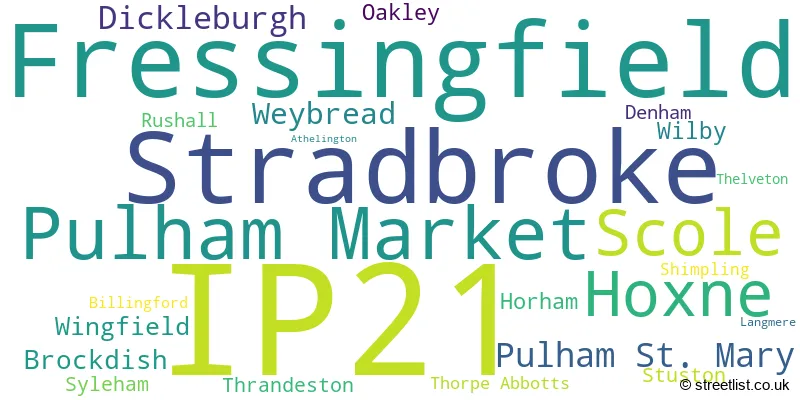
The largest settlement in the IP21 postal code is Stradbroke followed by Fressingfield, and Scole.
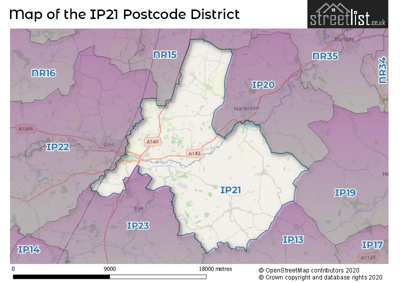
The IP21 Postcode shares a border with IP13 (Framlingham, Wickham Market, Grundisburgh), IP19 (HALESWORTH, Wenhaston, Holton), IP20 (HARLESTON, Alburgh, Metfield), IP22 (DISS, Roydon, Rickinghall), IP23 (EYE, Gislingham, Thorndon) and NR15 (Long Stratton, Brooke, Hempnall).
The primary settlement in the IP21 postcode district is Pulham Market, located in the county of Norfolk, England. Other significant settlements in this district include Dickleburgh, Scole, and Pulham St. Mary, all also located in Norfolk. The most significant post town in the district is Diss.
For the district IP21, we have data on 2 postcode sectors. Here's a breakdown: The sector IP21 4, covers Pulham Market and Scole and Pulham St. Mary and Dickleburgh in Norfolk. The sector IP21 5, covers Fressingfield and Stradbroke and Hoxne and Weybread in Suffolk.

Map of the IP21 Postcode District
Explore the IP21 postcode district by using our free interactive map.
When it comes to local government, postal geography often disregards political borders. However, for a breakdown in the IP21 District: the district mostly encompasses the Mid Suffolk District (298 postcodes), and finally, the South Norfolk District area (228 postcodes).
Recent House Sales in IP21
| Date | Price | Address |
|---|---|---|
| 20/10/2023 | £345,000 | The Street, Brockdish, Diss, IP21 4JY |
| 08/09/2023 | £300,000 | Millers Drive, Dickleburgh, Diss, IP21 4PX |
| 31/08/2023 | £525,000 | Low Street, Oakley, Diss, IP21 4AQ |
| 25/08/2023 | £265,000 | Priory Road, Fressingfield, Eye, IP21 5PH |
| 18/08/2023 | £587,500 | Burston Road, Dickleburgh, Diss, IP21 4NN |
| 17/08/2023 | £535,000 | The Green, Pulham Market, Diss, IP21 4SU |
| 17/08/2023 | £575,000 | Cratfield Road, Fressingfield, Eye, IP21 5QD |
| 04/08/2023 | £430,000 | The Street, Dickleburgh, Diss, IP21 4NQ |
| 04/08/2023 | £625,000 | Great Green, Thrandeston, Diss, IP21 4BN |
| 04/08/2023 | £538,000 | Chapel Close, Stradbroke, Eye, IP21 5JU |
Weather Forecast for IP21
Press Button to Show Forecast for Rushall (Norfolk)
| Time Period | Icon | Description | Temperature | Rain Probability | Wind |
|---|---|---|---|---|---|
| 00:00 to 03:00 | Cloudy | 5.0°C (feels like 2.0°C) | 5.00% | NE 4 mph | |
| 03:00 to 06:00 | Cloudy | 6.0°C (feels like 3.0°C) | 11.00% | NE 7 mph | |
| 06:00 to 09:00 | Heavy rain | 6.0°C (feels like 4.0°C) | 80.00% | ENE 7 mph | |
| 09:00 to 12:00 | Heavy rain | 7.0°C (feels like 4.0°C) | 81.00% | NE 11 mph | |
| 12:00 to 15:00 | Overcast | 9.0°C (feels like 6.0°C) | 17.00% | ENE 11 mph | |
| 15:00 to 18:00 | Overcast | 10.0°C (feels like 8.0°C) | 20.00% | NE 11 mph | |
| 18:00 to 21:00 | Cloudy | 10.0°C (feels like 7.0°C) | 9.00% | ENE 9 mph | |
| 21:00 to 00:00 | Light rain | 8.0°C (feels like 6.0°C) | 62.00% | NE 11 mph |
Press Button to Show Forecast for Rushall (Norfolk)
| Time Period | Icon | Description | Temperature | Rain Probability | Wind |
|---|---|---|---|---|---|
| 00:00 to 03:00 | Light rain | 8.0°C (feels like 6.0°C) | 66.00% | NE 11 mph | |
| 03:00 to 06:00 | Heavy rain | 9.0°C (feels like 7.0°C) | 90.00% | ENE 9 mph | |
| 06:00 to 09:00 | Light rain | 10.0°C (feels like 7.0°C) | 65.00% | S 11 mph | |
| 09:00 to 12:00 | Heavy rain shower (day) | 11.0°C (feels like 8.0°C) | 64.00% | SW 13 mph | |
| 12:00 to 15:00 | Heavy rain shower (day) | 11.0°C (feels like 8.0°C) | 63.00% | WSW 13 mph | |
| 15:00 to 18:00 | Heavy rain shower (day) | 10.0°C (feels like 7.0°C) | 61.00% | W 11 mph | |
| 18:00 to 21:00 | Cloudy | 9.0°C (feels like 7.0°C) | 14.00% | WSW 9 mph | |
| 21:00 to 00:00 | Partly cloudy (night) | 7.0°C (feels like 5.0°C) | 3.00% | SW 7 mph |
Press Button to Show Forecast for Rushall (Norfolk)
| Time Period | Icon | Description | Temperature | Rain Probability | Wind |
|---|---|---|---|---|---|
| 00:00 to 03:00 | Clear night | 6.0°C (feels like 4.0°C) | 3.00% | SW 9 mph | |
| 03:00 to 06:00 | Clear night | 5.0°C (feels like 3.0°C) | 2.00% | SSW 7 mph | |
| 06:00 to 09:00 | Sunny day | 6.0°C (feels like 4.0°C) | 1.00% | S 7 mph | |
| 09:00 to 12:00 | Sunny day | 11.0°C (feels like 9.0°C) | 3.00% | S 11 mph | |
| 12:00 to 15:00 | Cloudy | 14.0°C (feels like 11.0°C) | 5.00% | S 11 mph | |
| 15:00 to 18:00 | Partly cloudy (day) | 14.0°C (feels like 11.0°C) | 3.00% | SSE 13 mph | |
| 18:00 to 21:00 | Sunny day | 12.0°C (feels like 10.0°C) | 1.00% | SE 9 mph | |
| 21:00 to 00:00 | Clear night | 9.0°C (feels like 6.0°C) | 1.00% | SE 9 mph |
Press Button to Show Forecast for Rushall (Norfolk)
| Time Period | Icon | Description | Temperature | Rain Probability | Wind |
|---|---|---|---|---|---|
| 00:00 to 03:00 | Partly cloudy (night) | 8.0°C (feels like 6.0°C) | 3.00% | SE 7 mph | |
| 03:00 to 06:00 | Partly cloudy (night) | 7.0°C (feels like 5.0°C) | 5.00% | ESE 7 mph | |
| 06:00 to 09:00 | Cloudy | 9.0°C (feels like 8.0°C) | 8.00% | ESE 7 mph | |
| 09:00 to 12:00 | Cloudy | 13.0°C (feels like 12.0°C) | 11.00% | ESE 9 mph | |
| 12:00 to 15:00 | Cloudy | 15.0°C (feels like 13.0°C) | 11.00% | SE 9 mph | |
| 15:00 to 18:00 | Cloudy | 15.0°C (feels like 13.0°C) | 7.00% | SE 9 mph | |
| 18:00 to 21:00 | Cloudy | 14.0°C (feels like 12.0°C) | 7.00% | ESE 9 mph | |
| 21:00 to 00:00 | Cloudy | 11.0°C (feels like 10.0°C) | 21.00% | E 7 mph |
Where is the IP21 Postcode District?
The postcode district IP21 is located in the town of Eye in Suffolk. Eye is situated in between the nearby towns of Harleston (4.7 miles to the northeast) and Diss (5.8 miles to the northwest). The town of Halesworth is located 11.3 miles to the east, Saxmundham is located 14.6 miles to the southeast, and Norwich is located 15.4 miles to the west. Additionally, Eye is approximately 83.1 miles away from the center of London.
The district covers the post towns of DISS, EYE.
The sector has postcodes within the nation of England.
The IP21 Postcode District is covers the following regions.
- Suffolk - East Anglia - East of England
- Breckland and South Norfolk - East Anglia - East of England
| Postcode Sector | Delivery Office |
|---|---|
| IP21 4 | Diss Delivery Office |
| IP21 5 | Diss Delivery Office |
| I | P | 2 | 1 | - | X | X | X |
| I | P | 2 | 1 | Space | Numeric | Letter | Letter |
Current Monthly Rental Prices
| # Bedrooms | Min Price | Max Price | Avg Price |
|---|---|---|---|
| £1,400 | £1,400 | £1,400 | |
| 1 | £545 | £545 | £545 |
| 2 | £850 | £850 | £850 |
Current House Prices
| # Bedrooms | Min Price | Max Price | Avg Price |
|---|---|---|---|
| £145,000 | £450,000 | £297,500 | |
| 1 | £70,000 | £200,000 | £146,250 |
| 2 | £159,500 | £475,000 | £286,519 |
| 3 | £150,000 | £750,000 | £378,869 |
| 4 | £350,000 | £895,000 | £585,278 |
| 5 | £325,000 | £1,250,000 | £660,778 |
| 6 | £975,000 | £975,000 | £975,000 |
| 7 | £1,200,000 | £1,200,000 | £1,200,000 |
Estate Agents who Operate in the IP21 District
| Logo | Name | Brand Name | Address | Contact Number | Total Properties |
|---|---|---|---|---|---|
 | Diss | William H. Brown | Navire House, Mere Street, Diss, Norfolk, IP22 4AG | 01379 773565 | 17 |
 | Diss | Whittley Parish | 4-6 Market Hill, Diss, IP22 4JZ | 01379 777268 | 13 |
 | Diss | Fine & Country | Navire House Mere Street, Diss, IP22 4AG | 01379 777312 | 12 |
 | Diss | Starkings & Watson | 2 Carmel Works, Park Road, Diss, IP22 4AS | 01379 450950 | 11 |
 | Harleston | Durrants | 32-34 The Thoroughfare, Harleston, IP20 9AU | 01379 777097 | 8 |
- Ashfield Green
- Barley Green
- Battlesea Green
- Billingford
- Bleach Green
- Brockdish
- Brome
- Brome Street
- Bush Green
- Cratfield
- Cross Street
- Denham
- Dickleburgh
- Diss
- Fressingfield
- Furze Green
- Hardwick
- Harleston
- Heckfield Green
- Horham
- Hoxne
- Metfield
- Oakley
- Palgrave
- Pulham Market
- Pulham St Mary
- Redlingfield
- Rushall
- Scole Common
- Scole
- Shimpling
- Stradbroke
- Stuston
- Syleham
- Thelveton
- Thorpe Abbotts
- Thrandeston
- Tivetshall St Mary
- Upper Street
- Upper Weybread
- Waterloo
- Weybread
- Weybread Street
- Wilby
- Wingfield
- Wingfield Green
- Wootten Green
- Yaxley
| Type of Property | 2018 Average | 2018 Sales | 2017 Average | 2017 Sales | 2016 Average | 2016 Sales | 2015 Average | 2015 Sales |
|---|---|---|---|---|---|---|---|---|
| Detached | £396,861 | 94 | £373,144 | 98 | £345,389 | 103 | £309,817 | 111 |
| Semi-Detached | £245,615 | 48 | £224,149 | 47 | £224,823 | 50 | £211,424 | 55 |
| Terraced | £242,891 | 23 | £206,600 | 22 | £184,296 | 27 | £168,647 | 29 |
| Flats | £194,300 | 5 | £156,750 | 6 | £98,071 | 7 | £117,750 | 5 |