The L12 5 postcode sector is within the county of Merseyside.
Did you know? According to the 2021 Census, the L12 5 postcode sector is home to a bustling 3,615 residents!
Given that each sector allows for 400 unique postcode combinations. Letters C, I, K, M, O and V are not allowed in the last two letters of a postcode. With 70 postcodes already in use, this leaves 330 units available.
The largest settlements in the L12 5 postal code are LIVERPOOL and West Derby.
The L12 5 Postcode shares a border with L12 4 (LIVERPOOL, West Derby), L12 7 (LIVERPOOL, West Derby), L11 1 (LIVERPOOL, Norris Green), L12 8 (LIVERPOOL, West Derby), L12 0 (LIVERPOOL, West Derby) and L13 0 (LIVERPOOL, West Derby, Stoneycroft).
The sector is within the post town of LIVERPOOL.
L12 5 is a postcode sector within the L1 postcode district which is within the L Liverpool postcode area.
The Royal Mail delivery office for the L12 5 postal sector is the Liverpool 1-3.
The area of the L12 5 postcode sector is 0.39 square miles which is 1.01 square kilometres or 248.75 square acres.

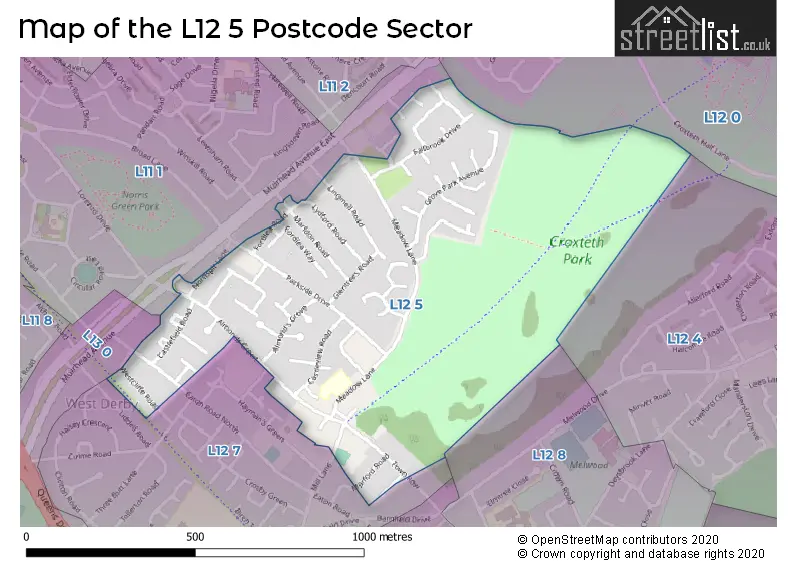
Map of the L12 5 Postcode Sector
Explore the L12 5 postcode sector by using our free interactive map.
| L | 1 | 2 | - | 5 | X | X |
| L | 1 | 2 | Space | 5 | Letter | Letter |
Official List of Streets
LIVERPOOL (43 Streets)
Unofficial Streets or Alternative Spellings
LIVERPOOL
CASTLE KEEP MUIRHEAD AVENUE MUIRHEAD AVENUE EASTWest Derby
MILL LANE HAYMANS GREEN LIVERPOOL LOOP LINEWeather Forecast for L12 5
Press Button to Show Forecast for West Derby
| Time Period | Icon | Description | Temperature | Rain Probability | Wind |
|---|---|---|---|---|---|
| 03:00 to 06:00 | Cloudy | 10.0°C (feels like 7.0°C) | 7.00% | SSE 16 mph | |
| 06:00 to 09:00 | Cloudy | 10.0°C (feels like 6.0°C) | 5.00% | SE 16 mph | |
| 09:00 to 12:00 | Cloudy | 12.0°C (feels like 8.0°C) | 8.00% | SE 18 mph | |
| 12:00 to 15:00 | Cloudy | 15.0°C (feels like 11.0°C) | 9.00% | SSE 18 mph | |
| 15:00 to 18:00 | Cloudy | 15.0°C (feels like 12.0°C) | 15.00% | SSE 16 mph | |
| 18:00 to 21:00 | Light rain shower (day) | 13.0°C (feels like 11.0°C) | 35.00% | SSE 11 mph | |
| 21:00 to 00:00 | Cloudy | 12.0°C (feels like 10.0°C) | 16.00% | SE 9 mph |
Press Button to Show Forecast for West Derby
| Time Period | Icon | Description | Temperature | Rain Probability | Wind |
|---|---|---|---|---|---|
| 00:00 to 03:00 | Cloudy | 10.0°C (feels like 9.0°C) | 9.00% | SE 7 mph | |
| 03:00 to 06:00 | Cloudy | 9.0°C (feels like 8.0°C) | 4.00% | SE 7 mph | |
| 06:00 to 09:00 | Cloudy | 9.0°C (feels like 7.0°C) | 4.00% | SE 7 mph | |
| 09:00 to 12:00 | Cloudy | 11.0°C (feels like 10.0°C) | 5.00% | ESE 7 mph | |
| 12:00 to 15:00 | Cloudy | 14.0°C (feels like 13.0°C) | 8.00% | SE 7 mph | |
| 15:00 to 18:00 | Cloudy | 15.0°C (feels like 14.0°C) | 13.00% | SSE 7 mph | |
| 18:00 to 21:00 | Cloudy | 14.0°C (feels like 13.0°C) | 12.00% | WNW 7 mph | |
| 21:00 to 00:00 | Cloudy | 13.0°C (feels like 12.0°C) | 11.00% | NW 7 mph |
Press Button to Show Forecast for West Derby
| Time Period | Icon | Description | Temperature | Rain Probability | Wind |
|---|---|---|---|---|---|
| 00:00 to 03:00 | Cloudy | 12.0°C (feels like 10.0°C) | 12.00% | NNW 7 mph | |
| 03:00 to 06:00 | Cloudy | 11.0°C (feels like 10.0°C) | 9.00% | NNW 7 mph | |
| 06:00 to 09:00 | Cloudy | 11.0°C (feels like 10.0°C) | 7.00% | NNW 7 mph | |
| 09:00 to 12:00 | Partly cloudy (day) | 13.0°C (feels like 11.0°C) | 5.00% | N 9 mph | |
| 12:00 to 15:00 | Sunny day | 16.0°C (feels like 14.0°C) | 5.00% | N 9 mph | |
| 15:00 to 18:00 | Sunny day | 17.0°C (feels like 15.0°C) | 3.00% | N 11 mph | |
| 18:00 to 21:00 | Sunny day | 17.0°C (feels like 14.0°C) | 4.00% | N 11 mph | |
| 21:00 to 00:00 | Clear night | 14.0°C (feels like 12.0°C) | 3.00% | NNE 9 mph |
Schools and Places of Education Within the L12 5 Postcode Sector
St Mary's Church of England Primary School, West Derby
Voluntary aided school
Meadow Lane, Liverpool, Merseyside, L12 5EA
Head: Mr Dave Harrop
Ofsted Rating: Good
Inspection: 2021-12-01 (881 days ago)
Website: Visit St Mary's Church of England Primary School, West Derby Website
Phone: 01512262038
Number of Pupils: 209
House Prices in the L12 5 Postcode Sector
| Type of Property | 2018 Average | 2018 Sales | 2017 Average | 2017 Sales | 2016 Average | 2016 Sales | 2015 Average | 2015 Sales |
|---|---|---|---|---|---|---|---|---|
| Detached | £271,184 | 14 | £266,143 | 7 | £222,288 | 12 | £231,063 | 8 |
| Semi-Detached | £185,120 | 33 | £157,060 | 21 | £152,039 | 23 | £152,350 | 17 |
| Terraced | £132,518 | 11 | £116,850 | 8 | £116,458 | 12 | £95,330 | 10 |
| Flats | £102,500 | 1 | £104,582 | 3 | £94,000 | 1 | £108,750 | 2 |
Important Postcodes L12 5 in the Postcode Sector
L12 5EA is the postcode for St. Marys West Derby C of E Primary School, Meadow Lane, West Derby, and St. Marys West Derby C of E Primary School, Meadow Lane
L12 5EH is the postcode for Dental Disposable Products Ltd, 98 Parkside Drive
| The L12 5 Sector is within these Local Authorities |
|
|---|---|
| The L12 5 Sector is within these Counties |
|
| The L12 5 Sector is within these Water Company Areas |
|