The L13 0 postcode sector is within the county of Merseyside.
Did you know? According to the 2021 Census, the L13 0 postcode sector is home to a bustling 2,186 residents!
Given that each sector allows for 400 unique postcode combinations. Letters C, I, K, M, O and V are not allowed in the last two letters of a postcode. With 44 postcodes already in use, this leaves 356 units available.
The largest settlement in the L13 0 postal code is LIVERPOOL followed by West Derby, and Stoneycroft.
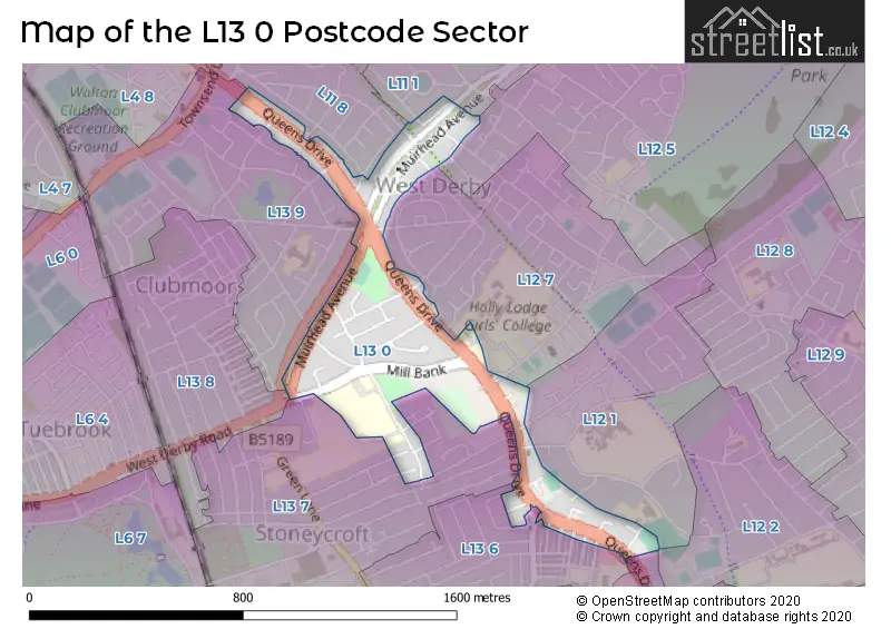
The L13 0 Postcode shares a border with L13 8 (LIVERPOOL, Tuebrook), L12 1 (LIVERPOOL, West Derby, Sandfield Park), L12 5 (LIVERPOOL, West Derby), L12 7 (LIVERPOOL, West Derby), L11 1 (LIVERPOOL, Norris Green), L11 8 (LIVERPOOL, Norris Green, West Derby), L12 2 (West Derby, LIVERPOOL, Sandfield Park), L13 5 (LIVERPOOL, Old Swan, Stoneycroft), L13 6 (LIVERPOOL, Stoneycroft, Old Swan), L13 7 (LIVERPOOL, Stoneycroft, Old Swan) and L13 9 (LIVERPOOL, Clubmoor).
The sector is within the post town of LIVERPOOL.
L13 0 is a postcode sector within the L1 postcode district which is within the L Liverpool postcode area.
The Royal Mail delivery office for the L13 0 postal sector is the Liverpool 1-3.
The area of the L13 0 postcode sector is 0.24 square miles which is 0.63 square kilometres or 155.31 square acres.

Map of the L13 0 Postcode Sector
Explore the L13 0 postcode sector by using our free interactive map.
| L | 1 | 3 | - | 0 | X | X |
| L | 1 | 3 | Space | 0 | Letter | Letter |
Official List of Streets
LIVERPOOL (18 Streets)
West Derby (2 Streets)
Stoneycroft (1 Streets)
Old Swan (1 Streets)
Unofficial Streets or Alternative Spellings
Sandfield Park
NEW HEYLIVERPOOL
ADSHEAD ROAD AGAR ROAD ALTHAM ROAD BINGLE WAY CLASSIC ROAD CULME ROAD DERBY LANE EASTMAN ROAD EATON ROAD NORTH FLORENTINE ROAD HALSEY AVENUE HUGHENDEN ROAD INIGO ROAD KREMLIN DRIVE LARKHILL PLACE LIDDELL ROAD MARLOWE DRIVE MONASH ROAD MORNINGSIDE ROAD MOSCOW DRIVE PALLADIO ROAD PODIUM ROAD RICHLAND ROAD ROCKBANK ROAD SANDFORTH ROAD STONEYCROFT CRESCENT THREE BUTT LANE UPPINGHAM ROAD WESTCLIFFE ROAD LIVERPOOL LOOP LINE QUEENS DRIVE STONEYCROFT QUEENS DRIVE WEST DERBYWest Derby
FERGUSON ROAD MILL LANEOld Swan
QUARRY ROADWeather Forecast for L13 0
Press Button to Show Forecast for West Derby
| Time Period | Icon | Description | Temperature | Rain Probability | Wind |
|---|---|---|---|---|---|
| 06:00 to 09:00 | Cloudy | 10.0°C (feels like 6.0°C) | 5.00% | SE 16 mph | |
| 09:00 to 12:00 | Cloudy | 12.0°C (feels like 8.0°C) | 8.00% | SE 18 mph | |
| 12:00 to 15:00 | Cloudy | 15.0°C (feels like 11.0°C) | 9.00% | SSE 18 mph | |
| 15:00 to 18:00 | Cloudy | 15.0°C (feels like 12.0°C) | 15.00% | SSE 16 mph | |
| 18:00 to 21:00 | Light rain shower (day) | 13.0°C (feels like 11.0°C) | 35.00% | SSE 11 mph | |
| 21:00 to 00:00 | Cloudy | 12.0°C (feels like 10.0°C) | 16.00% | SE 9 mph |
Press Button to Show Forecast for West Derby
| Time Period | Icon | Description | Temperature | Rain Probability | Wind |
|---|---|---|---|---|---|
| 00:00 to 03:00 | Cloudy | 10.0°C (feels like 9.0°C) | 9.00% | SE 7 mph | |
| 03:00 to 06:00 | Cloudy | 9.0°C (feels like 8.0°C) | 4.00% | SE 7 mph | |
| 06:00 to 09:00 | Cloudy | 9.0°C (feels like 7.0°C) | 4.00% | SE 7 mph | |
| 09:00 to 12:00 | Cloudy | 11.0°C (feels like 10.0°C) | 5.00% | ESE 7 mph | |
| 12:00 to 15:00 | Cloudy | 14.0°C (feels like 13.0°C) | 8.00% | SE 7 mph | |
| 15:00 to 18:00 | Cloudy | 15.0°C (feels like 14.0°C) | 13.00% | SSE 7 mph | |
| 18:00 to 21:00 | Cloudy | 14.0°C (feels like 13.0°C) | 12.00% | WNW 7 mph | |
| 21:00 to 00:00 | Cloudy | 13.0°C (feels like 12.0°C) | 11.00% | NW 7 mph |
Press Button to Show Forecast for West Derby
| Time Period | Icon | Description | Temperature | Rain Probability | Wind |
|---|---|---|---|---|---|
| 00:00 to 03:00 | Cloudy | 12.0°C (feels like 10.0°C) | 12.00% | NNW 7 mph | |
| 03:00 to 06:00 | Cloudy | 11.0°C (feels like 10.0°C) | 9.00% | NNW 7 mph | |
| 06:00 to 09:00 | Cloudy | 11.0°C (feels like 10.0°C) | 7.00% | NNW 7 mph | |
| 09:00 to 12:00 | Partly cloudy (day) | 13.0°C (feels like 11.0°C) | 5.00% | N 9 mph | |
| 12:00 to 15:00 | Sunny day | 16.0°C (feels like 14.0°C) | 5.00% | N 9 mph | |
| 15:00 to 18:00 | Sunny day | 17.0°C (feels like 15.0°C) | 3.00% | N 11 mph | |
| 18:00 to 21:00 | Sunny day | 17.0°C (feels like 14.0°C) | 4.00% | N 11 mph | |
| 21:00 to 00:00 | Clear night | 14.0°C (feels like 12.0°C) | 3.00% | NNE 9 mph |
Schools and Places of Education Within the L13 0 Postcode Sector
Ernest Cookson School
Community special school
Bankfield Road, Liverpool, Merseyside, L13 0BQ
Head: Headteacher Geraldine James
Ofsted Rating: Outstanding
Inspection: 2019-07-02 (1764 days ago)
Website: Visit Ernest Cookson School Website
Phone: 01513305121
Number of Pupils: 65
House Prices in the L13 0 Postcode Sector
| Type of Property | 2018 Average | 2018 Sales | 2017 Average | 2017 Sales | 2016 Average | 2016 Sales | 2015 Average | 2015 Sales |
|---|---|---|---|---|---|---|---|---|
| Detached | £0 | 0 | £282,500 | 1 | £0 | 0 | £138,000 | 1 |
| Semi-Detached | £141,500 | 14 | £132,545 | 11 | £122,495 | 11 | £126,845 | 10 |
| Terraced | £129,750 | 10 | £142,500 | 6 | £118,056 | 9 | £103,071 | 7 |
| Flats | £72,017 | 3 | £71,139 | 9 | £68,085 | 10 | £70,750 | 4 |
Important Postcodes L13 0 in the Postcode Sector
L13 0AE is the postcode for ROSALIND FRANKLIN BUILDING, Holly Lodge Girls College, Queens Drive, MAIN BUILDING, Holly Lodge Girls College, Queens Drive, PAVILION BUILDING, Holly Lodge Girls College, Queens Drive, ALEXANDRA BUILDING, Holly Lodge Girls College, Queens Drive, Holly Lodge Girls College, Queens Drive, RESTAURANT AND KITCHEN BUILDING, Holly Lodge Girls College, Queens Drive, SANDHEYS BUILDING, Holly Lodge Girls College, Queens Drive, and TURNER BUILDING, Holly Lodge Girls College, Queens Drive
L13 0BE is the postcode for West Derby Comprehensive School, Bankfield Wing, Bankfield Road
L13 0BQ is the postcode for The City of Liverpool College, Bankfield Centre, Bankfield Road, Peter Lloyd Leisure Centre, Bankfield Road, and Ernest Cookson School, 54 Bankfield Road
| The L13 0 Sector is within these Local Authorities |
|
|---|---|
| The L13 0 Sector is within these Counties |
|
| The L13 0 Sector is within these Water Company Areas |
|