The LE5 4 postcode sector is within the county of Leicestershire.
Did you know? According to the 2021 Census, the LE5 4 postcode sector is home to a bustling 14,487 residents!
Given that each sector allows for 400 unique postcode combinations. Letters C, I, K, M, O and V are not allowed in the last two letters of a postcode. With 210 postcodes already in use, this leaves 190 units available.
The LE5 4 postal code covers the settlement of LEICESTER.
The LE5 4 Postcode shares a border with LE5 1 (Hamilton, LEICESTER, Humberstone), LE5 2 (LEICESTER), LE5 5 (LEICESTER), LE5 6 (LEICESTER, Evington), LE5 0 (LEICESTER) and LE5 3 (LEICESTER).
The sector is within the post town of LEICESTER.
LE5 4 is a postcode sector within the LE5 postcode district which is within the LE Leicester postcode area.
The Royal Mail delivery office for the LE5 4 postal sector is the Leicester East Delivery Office.
The area of the LE5 4 postcode sector is 0.93 square miles which is 2.40 square kilometres or 592.46 square acres.

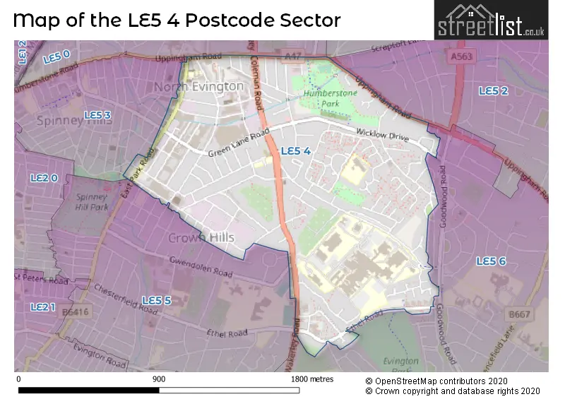
Map of the LE5 4 Postcode Sector
Explore the LE5 4 postcode sector by using our free interactive map.
| L | E | 5 | - | 4 | X | X |
| L | E | 5 | Space | 4 | Letter | Letter |
Official List of Streets
LEICESTER (113 Streets)
Unofficial Streets or Alternative Spellings
Bushby
UPPINGHAM ROADLEICESTER
CONSTANCE ROAD DOROTHY ROAD DRINKSTONE ROAD GEDDING ROAD GOODWOOD ROAD GREENACRE DRIVE HEADLAND ROAD HILLCROFT ROAD HUMBERSTONE DRIVE LONDON STREET MARTIVAL NANSEN ROAD ORSON STREET OSBORNE ROAD PETERS DRIVE SPENCE STREET STONEBRIDGE STREET THE PORTWEY THE RETREAT TURNER ROAD VENTNOR STREET BARNABAS ROAD BENS WAY BIRKENSHAW WAY CLOVELLY ROAD CROSS WALK ELWOOD CLOSE IFFLEY CLOSE MATERNITY ENTRANCE MCKENZIE WALK ROSEBERRY STREET SAINT SAVIOURS ROAD SANDFORD CLOSE THE WAYNE WARD TURNER WALKScraptoft
SCRAPTOFT LANEWeather Forecast for LE5 4
Press Button to Show Forecast for North Evington
| Time Period | Icon | Description | Temperature | Rain Probability | Wind |
|---|---|---|---|---|---|
| 18:00 to 21:00 | Light rain | 12.0°C (feels like 10.0°C) | 48.00% | WSW 11 mph | |
| 21:00 to 00:00 | Overcast | 11.0°C (feels like 9.0°C) | 15.00% | WSW 11 mph |
Press Button to Show Forecast for North Evington
| Time Period | Icon | Description | Temperature | Rain Probability | Wind |
|---|---|---|---|---|---|
| 00:00 to 03:00 | Cloudy | 10.0°C (feels like 8.0°C) | 11.00% | SW 9 mph | |
| 03:00 to 06:00 | Partly cloudy (night) | 8.0°C (feels like 6.0°C) | 6.00% | SW 9 mph | |
| 06:00 to 09:00 | Partly cloudy (day) | 9.0°C (feels like 7.0°C) | 4.00% | SW 9 mph | |
| 09:00 to 12:00 | Cloudy | 12.0°C (feels like 10.0°C) | 6.00% | SSW 11 mph | |
| 12:00 to 15:00 | Partly cloudy (day) | 15.0°C (feels like 13.0°C) | 5.00% | SSW 11 mph | |
| 15:00 to 18:00 | Cloudy | 16.0°C (feels like 14.0°C) | 11.00% | SSW 9 mph | |
| 18:00 to 21:00 | Cloudy | 15.0°C (feels like 14.0°C) | 11.00% | S 7 mph | |
| 21:00 to 00:00 | Partly cloudy (night) | 12.0°C (feels like 10.0°C) | 5.00% | SSE 7 mph |
Press Button to Show Forecast for North Evington
| Time Period | Icon | Description | Temperature | Rain Probability | Wind |
|---|---|---|---|---|---|
| 00:00 to 03:00 | Partly cloudy (night) | 10.0°C (feels like 9.0°C) | 6.00% | S 7 mph | |
| 03:00 to 06:00 | Cloudy | 9.0°C (feels like 7.0°C) | 12.00% | S 7 mph | |
| 06:00 to 09:00 | Cloudy | 10.0°C (feels like 8.0°C) | 14.00% | SSE 7 mph | |
| 09:00 to 12:00 | Cloudy | 13.0°C (feels like 12.0°C) | 9.00% | SSE 7 mph | |
| 12:00 to 15:00 | Cloudy | 15.0°C (feels like 13.0°C) | 12.00% | SE 7 mph | |
| 15:00 to 18:00 | Light rain shower (day) | 16.0°C (feels like 14.0°C) | 35.00% | SE 7 mph | |
| 18:00 to 21:00 | Cloudy | 14.0°C (feels like 13.0°C) | 12.00% | WSW 7 mph | |
| 21:00 to 00:00 | Cloudy | 12.0°C (feels like 10.0°C) | 10.00% | W 7 mph |
Schools and Places of Education Within the LE5 4 Postcode Sector
Al-Aqsa Schools Trust
Other independent school
The Wayne Way, Leicester, Leicestershire, LE5 4PP
Head: Mr Abdelhamid Chachi
Ofsted Rating: Good
Inspection: 2022-02-03 (820 days ago)
Website: Visit Al-Aqsa Schools Trust Website
Phone: 01162760953
Number of Pupils: 296
Ash Field Academy
Academy special converter
Broad Avenue, Leicester, , LE5 4PY
Head: Miss Tracey Lawrence
Ofsted Rating: Outstanding
Inspection: 2017-11-21 (2355 days ago)
Website: Visit Ash Field Academy Website
Phone: 01162737151
Number of Pupils: 165
Rowlatts Mead Primary Academy
Academy converter
Balderstone Close, Leicester, Leicestershire, LE5 4ES
Head: Mrs Jennie Henson
Ofsted Rating: Good
Inspection: 2023-10-04 (212 days ago)
Website: Visit Rowlatts Mead Primary Academy Website
Phone: 01162768812
Number of Pupils: 365
St Barnabas CofE Primary School
Voluntary controlled school
St Barnabas Road, Leicester, Leicestershire, LE5 4BD
Head: Mr Steve Nash
Ofsted Rating: Good
Inspection: 2023-06-28 (310 days ago)
Website: Visit St Barnabas CofE Primary School Website
Phone: 01162767612
Number of Pupils: 336
House Prices in the LE5 4 Postcode Sector
| Type of Property | 2018 Average | 2018 Sales | 2017 Average | 2017 Sales | 2016 Average | 2016 Sales | 2015 Average | 2015 Sales |
|---|---|---|---|---|---|---|---|---|
| Detached | £282,450 | 9 | £252,500 | 2 | £234,667 | 3 | £271,990 | 5 |
| Semi-Detached | £213,843 | 35 | £204,210 | 31 | £187,224 | 42 | £175,879 | 29 |
| Terraced | £174,952 | 68 | £157,649 | 53 | £147,329 | 61 | £136,607 | 64 |
| Flats | £70,050 | 10 | £73,357 | 14 | £71,550 | 10 | £64,359 | 11 |
Important Postcodes LE5 4 in the Postcode Sector
LE5 4AH is the postcode for Leicester City Council, St. Barnabas Library, French Road
LE5 4BD is the postcode for St. Barnabas C of E Primary School, St. Barnabas Road
LE5 4BP is the postcode for UPPINGHAM ROAD HEALTH CENTRE, 131 UPPINGHAM ROAD, LEICESTER, and Uppingham Road Health Centre, 131 Uppingham Road
LE5 4ES is the postcode for ROWLATTS MEAD PRIMARY ACADEMY, BALDERSTONE CLOSE, LEICESTER, Rowlatts Hill Primary School, Balderstone Close, and Coleman Neighbourhood Centre, Balderstone Close
LE5 4LH is the postcode for Coleman Road Ambulance Station, Coleman Road
LE5 4LJ is the postcode for The Willows Medical Centre, 184 Coleman Road
LE5 4LU is the postcode for Barnes Heath House, Humphries Close
LE5 4PW is the postcode for WAKERLEY LODGE, University Hospitals Of Leicester NHS Trust, Leicester General Hospital, MAIN BUILDING, University Hospitals Of Leicester NHS Trust, Leicester General Hospital, University Hospitals Of Leicester NHS Trust, Leicester General Hospital, THE NEVILLE CENTRE, University Hospitals Of Leicester NHS Trust, Leicester General Hospital, RENAL UNIT, University Hospitals Of Leicester NHS Trust, Leicester General Hospital, Leicestershire Partnership NHS Trust, Brandon Mental Health Unit, and The Neville Centre,, Leicester General Hospital,
LE5 4PY is the postcode for ASH FIELD ACADEMY, BROAD AVENUE, LEICESTER, Ash Field Academy, Broad Avenue, and SECONDARY BLOCK, Ash Field Academy, Broad Avenue
LE5 4QF is the postcode for University Hospitals of Leicester NHS Trust, Gwendolen House, and Gwendolen House, Gwendolen Road
LE5 4QG is the postcode for Leicestershire NHS Trust, Evington Centre, Gwendolen Road, and Evington Centre, Leicester General Hospital, Gwendolen Road
| The LE5 4 Sector is within these Local Authorities |
|
|---|---|
| The LE5 4 Sector is within these Counties |
|
| The LE5 4 Sector is within these Water Company Areas |
|