The LE5 3 postcode sector is within the county of Leicestershire.
Did you know? According to the 2021 Census, the LE5 3 postcode sector is home to a bustling 12,586 residents!
Given that each sector allows for 400 unique postcode combinations. Letters C, I, K, M, O and V are not allowed in the last two letters of a postcode. With 160 postcodes already in use, this leaves 240 units available.
The LE5 3 postal code covers the settlement of LEICESTER.
The LE5 3 Postcode shares a border with LE5 4 (LEICESTER), LE5 5 (LEICESTER), LE1 2 (LEICESTER), LE1 1 (LEICESTER), LE2 0 (LEICESTER) and LE5 0 (LEICESTER).
The sector is within the post town of LEICESTER.
LE5 3 is a postcode sector within the LE5 postcode district which is within the LE Leicester postcode area.
The Royal Mail delivery office for the LE5 3 postal sector is the Leicester East Delivery Office.
The area of the LE5 3 postcode sector is 0.28 square miles which is 0.73 square kilometres or 181.28 square acres.

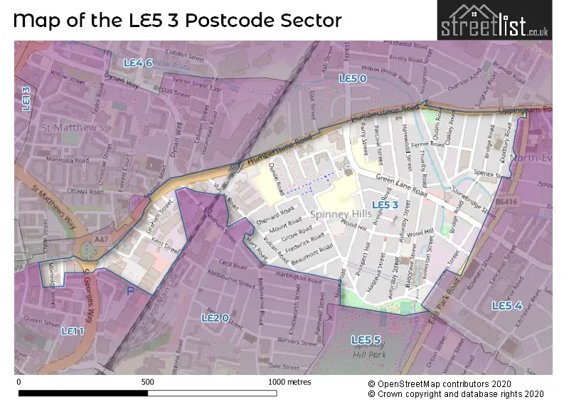
Map of the LE5 3 Postcode Sector
Explore the LE5 3 postcode sector by using our free interactive map.
| L | E | 5 | - | 3 | X | X |
| L | E | 5 | Space | 3 | Letter | Letter |
Official List of Streets
LEICESTER (75 Streets)
Unofficial Streets or Alternative Spellings
Bushby
UPPINGHAM ROAD ALBERTA STREET BARNABAS ROAD HARAMEAD ROAD HERON ROAD JAME WALK SAINT SAVIOURS ROAD ST BARNABAS ROAD ST GEORGES WAY SYSTON STREET EAST WINCHAT ROADLEICESTER
ANN STREET BURTON STREET CLYDE STREET DYSART WAY EAST PARK ROAD FARRINGDON STREET FOREST ROAD LAYTON ROAD MALABAR ROAD MAYNARD ROAD MORLEDGE STREET NEDHAM STREET OAK STREET OVERTON ROAD PEMBROKE STREET REDWOOD WALK SULGRAVE ROAD UPPER CHARNWOOD STREET WILLIAM STREET WILLOW BROOK ROAD WIMBLEDON STREETWeather Forecast for LE5 3
Press Button to Show Forecast for New Humberstone
| Time Period | Icon | Description | Temperature | Rain Probability | Wind |
|---|---|---|---|---|---|
| 21:00 to 00:00 | Cloudy | 6.0°C (feels like 4.0°C) | 6.00% | ENE 9 mph |
Press Button to Show Forecast for New Humberstone
| Time Period | Icon | Description | Temperature | Rain Probability | Wind |
|---|---|---|---|---|---|
| 00:00 to 03:00 | Cloudy | 6.0°C (feels like 3.0°C) | 7.00% | ENE 7 mph | |
| 03:00 to 06:00 | Cloudy | 5.0°C (feels like 2.0°C) | 6.00% | NE 7 mph | |
| 06:00 to 09:00 | Cloudy | 5.0°C (feels like 2.0°C) | 10.00% | NE 7 mph | |
| 09:00 to 12:00 | Cloudy | 8.0°C (feels like 5.0°C) | 48.00% | ENE 9 mph | |
| 12:00 to 15:00 | Overcast | 8.0°C (feels like 5.0°C) | 22.00% | ENE 11 mph | |
| 15:00 to 18:00 | Overcast | 8.0°C (feels like 5.0°C) | 16.00% | NE 11 mph | |
| 18:00 to 21:00 | Overcast | 8.0°C (feels like 4.0°C) | 15.00% | NE 11 mph | |
| 21:00 to 00:00 | Overcast | 6.0°C (feels like 3.0°C) | 12.00% | NE 11 mph |
Press Button to Show Forecast for New Humberstone
| Time Period | Icon | Description | Temperature | Rain Probability | Wind |
|---|---|---|---|---|---|
| 00:00 to 03:00 | Overcast | 6.0°C (feels like 3.0°C) | 21.00% | NNE 11 mph | |
| 03:00 to 06:00 | Light rain | 6.0°C (feels like 2.0°C) | 58.00% | N 13 mph | |
| 06:00 to 09:00 | Heavy rain | 6.0°C (feels like 2.0°C) | 87.00% | N 13 mph | |
| 09:00 to 12:00 | Heavy rain | 7.0°C (feels like 3.0°C) | 81.00% | NNW 11 mph | |
| 12:00 to 15:00 | Light rain | 8.0°C (feels like 5.0°C) | 58.00% | NW 11 mph | |
| 15:00 to 18:00 | Light rain | 10.0°C (feels like 8.0°C) | 49.00% | WNW 9 mph | |
| 18:00 to 21:00 | Partly cloudy (day) | 10.0°C (feels like 8.0°C) | 7.00% | W 9 mph | |
| 21:00 to 00:00 | Partly cloudy (night) | 7.0°C (feels like 5.0°C) | 3.00% | SW 7 mph |
Press Button to Show Forecast for New Humberstone
| Time Period | Icon | Description | Temperature | Rain Probability | Wind |
|---|---|---|---|---|---|
| 00:00 to 03:00 | Partly cloudy (night) | 6.0°C (feels like 3.0°C) | 1.00% | SSW 7 mph | |
| 03:00 to 06:00 | Clear night | 4.0°C (feels like 2.0°C) | 1.00% | SSW 7 mph | |
| 06:00 to 09:00 | Sunny day | 5.0°C (feels like 3.0°C) | 1.00% | S 7 mph | |
| 09:00 to 12:00 | Sunny day | 11.0°C (feels like 8.0°C) | 1.00% | S 11 mph | |
| 12:00 to 15:00 | Cloudy | 13.0°C (feels like 10.0°C) | 6.00% | S 13 mph | |
| 15:00 to 18:00 | Cloudy | 14.0°C (feels like 11.0°C) | 6.00% | S 13 mph | |
| 18:00 to 21:00 | Sunny day | 13.0°C (feels like 11.0°C) | 2.00% | S 11 mph | |
| 21:00 to 00:00 | Clear night | 9.0°C (feels like 7.0°C) | 2.00% | SSE 9 mph |
Press Button to Show Forecast for New Humberstone
| Time Period | Icon | Description | Temperature | Rain Probability | Wind |
|---|---|---|---|---|---|
| 00:00 to 03:00 | Clear night | 8.0°C (feels like 5.0°C) | 3.00% | SE 9 mph | |
| 03:00 to 06:00 | Clear night | 7.0°C (feels like 4.0°C) | 3.00% | SE 9 mph | |
| 06:00 to 09:00 | Sunny day | 8.0°C (feels like 6.0°C) | 4.00% | ESE 9 mph | |
| 09:00 to 12:00 | Cloudy | 13.0°C (feels like 11.0°C) | 7.00% | ESE 11 mph | |
| 12:00 to 15:00 | Partly cloudy (day) | 15.0°C (feels like 13.0°C) | 7.00% | SE 11 mph | |
| 15:00 to 18:00 | Partly cloudy (day) | 16.0°C (feels like 14.0°C) | 9.00% | SE 11 mph | |
| 18:00 to 21:00 | Cloudy | 14.0°C (feels like 13.0°C) | 9.00% | ESE 9 mph | |
| 21:00 to 00:00 | Cloudy | 12.0°C (feels like 10.0°C) | 10.00% | ESE 9 mph |
Schools and Places of Education Within the LE5 3 Postcode Sector
Bridge Junior School
Community school
Mere Close, Leicester, Leicestershire, LE5 3HH
Head: Ms Mina Vig
Ofsted Rating: Requires improvement
Inspection: 2022-11-30 (513 days ago)
Website: Visit Bridge Junior School Website
Phone:
Number of Pupils: 360
Green Lane Infant School
Academy converter
Spinney Hill Road, Leicester, Leicestershire, LE5 3GG
Head: Mrs Rebecca Conway
Ofsted Rating: Good
Inspection: 2023-04-26 (366 days ago)
Website: Visit Green Lane Infant School Website
Phone: 01162627050
Number of Pupils: 317
Sacred Heart Catholic Voluntary Academy
Academy converter
Mere Close, Leicester, Leicestershire, LE5 3HH
Head: Mrs Catherine Hayles
Ofsted Rating: Good
Inspection: 2021-11-04 (904 days ago)
Website: Visit Sacred Heart Catholic Voluntary Academy Website
Phone: 01162624418
Number of Pupils: 396
Shenton Primary School
Community school
Dunlin Road, Leicester, Leicestershire, LE5 3FP
Head: Ms Gita Patel
Ofsted Rating: Good
Inspection: 2020-01-29 (1549 days ago)
Website: Visit Shenton Primary School Website
Phone: 01162628778
Number of Pupils: 457
The Imam Muhammad Adam Institute School
Other independent school
97 Bridge Road, Leicester, , LE5 3LD
Head: Mr Fahim Sader
Ofsted Rating: Good
Inspection: 2021-06-24 (1037 days ago)
Website: Visit The Imam Muhammad Adam Institute School Website
Phone: 01162767600
Number of Pupils: 215
House Prices in the LE5 3 Postcode Sector
| Type of Property | 2018 Average | 2018 Sales | 2017 Average | 2017 Sales | 2016 Average | 2016 Sales | 2015 Average | 2015 Sales |
|---|---|---|---|---|---|---|---|---|
| Detached | £0 | 0 | £208,500 | 2 | £175,000 | 1 | £0 | 0 |
| Semi-Detached | £180,000 | 2 | £140,000 | 1 | £136,750 | 2 | £114,500 | 2 |
| Terraced | £170,098 | 51 | £147,945 | 73 | £132,665 | 65 | £132,543 | 90 |
| Flats | £115,000 | 1 | £99,000 | 2 | £78,367 | 3 | £0 | 0 |
Important Postcodes LE5 3 in the Postcode Sector
LE5 3FP is the postcode for Shenton Primary School, Dunlin Road
LE5 3FS is the postcode for Preston Lodge, 20 Kingfisher Avenue
LE5 3GG is the postcode for Green Lane Infant School, Spinney Hill Road
LE5 3GH is the postcode for 1, Spinney Hill Road, and Merlyn Vaz Health & Social Care Centre, 1 Spinney Hill Road
LE5 3HH is the postcode for Bridge Junior School, Mere Close, 'Sacred Heart Catholic Voluntary Academy, Mere Close, SACRED HEART CATHOLIC VOLUNTARY ACADEMY, MERE CLOSE, LEICESTER, and Sacred Heart Catholic Voluntary Academy, Mere Close
LE5 3NW is the postcode for Spence Street Sports Centre, Spence Street, and SPORTS HALL, Spence Street Sports Centre, Spence Street
| The LE5 3 Sector is within these Local Authorities |
|
|---|---|
| The LE5 3 Sector is within these Counties |
|
| The LE5 3 Sector is within these Water Company Areas |
|