The LE7 4 postcode sector is within the county of Leicestershire.
Did you know? According to the 2021 Census, the LE7 4 postcode sector is home to a bustling 3,748 residents!
Given that each sector allows for 400 unique postcode combinations. Letters C, I, K, M, O and V are not allowed in the last two letters of a postcode. With 113 postcodes already in use, this leaves 287 units available.
The largest settlement in the LE7 4 postal code is Rearsby followed by Thrussington, and Cossington.
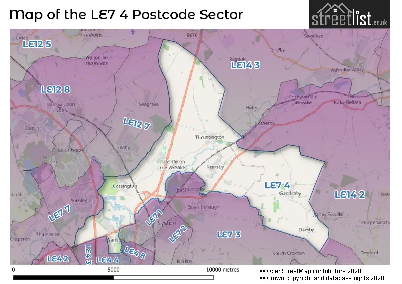
The LE7 4 Postcode shares a border with LE4 3 (Birstall), LE4 4 (Birstall), LE4 8 (Thurmaston), LE7 3 (Queniborough, East Goscote, Barkby), LE7 7 (Anstey, Rothley, Cropston), LE7 9 (Scraptoft, Thurnby, Houghton-on-the-Hill), LE12 7 (Sileby, Mountsorrel, Seagrave), LE14 2 (Wymondham, Frisby On The Wreake, Great Dalby), LE14 3 (Asfordby, Old Dalby, Asfordby Hill) and LE7 1 (Syston).
The sector is within the post town of LEICESTER.
LE7 4 is a postcode sector within the LE7 postcode district which is within the LE Leicester postcode area.
The Royal Mail delivery office for the LE7 4 postal sector is the Syston Scale Payment Delivery Office.
The area of the LE7 4 postcode sector is 17.76 square miles which is 46.01 square kilometres or 11,368.76 square acres.
The LE7 4 postcode sector is crossed by the A46 Major A road.
Waterways within the LE7 4 postcode sector include the Grand Union Canal, River Soar, River Wreake, River Wreake; Grand Union Canal, Rearsby Brook, Syston Brook.

Map of the LE7 4 Postcode Sector
Explore the LE7 4 postcode sector by using our free interactive map.
| L | E | 7 | - | 4 | X | X |
| L | E | 7 | Space | 4 | Letter | Letter |
Official List of Streets
Barsby (8 Streets)
Gaddesby (13 Streets)
Rearsby (26 Streets)
Cossington (12 Streets)
Thrussington (15 Streets)
Ratcliffe On The Wreake (5 Streets)
Wanlip (5 Streets)
LEICESTER (3 Streets)
Unofficial Streets or Alternative Spellings
East Goscote
BROOME LANE THE HEADLANDQueniborough
MELTON ROADFrisby On The Wreake
GADDESBY LANEAshby Folville
PASTURE LANESouth Croxton
THREE TURNS LANESyston
FOSSE WAY MEADOW LANE WANLIP ROADBirstall
LOUGHBOROUGH ROAD WANLIP LANESileby
COSSINGTON ROADRothley
COSSINGTON LANEBarrow Upon Soar
PAUDY LANEWalton On The Wolds
SIX HILLS ROADSeagrave
PARK HILL LANESchools and Places of Education Within the LE7 4 Postcode Sector
Cossington Church of England Primary School
Voluntary controlled school
Main Street, LEICESTER, Leicestershire, LE7 4UU
Head: Mr Matthew Yandell
Ofsted Rating: Good
Inspection: 2023-03-02 (448 days ago)
Website: Visit Cossington Church of England Primary School Website
Phone: 01509812565
Number of Pupils: 106
Gaddesby Primary School
Academy converter
Ashby Road, Leicester, Leicestershire, LE7 4WF
Head: Mr Leigh Fox
Ofsted Rating: Good
Inspection: 2023-11-29 (176 days ago)
Website: Visit Gaddesby Primary School Website
Phone: 01664840253
Number of Pupils: 191
St Michael & All Angels Church of England Primary School
Academy converter
Brookside, Leicester, Leicestershire, LE7 4YB
Head: Mr Neil Bardsley
Ofsted Rating: Good
Inspection: 2023-12-07 (168 days ago)
Website: Visit St Michael & All Angels Church of England Primary School Website
Phone: 01664424453
Number of Pupils: 78
Thrussington Church of England Primary School
Academy converter
Hoby Road, Leicester, Leicestershire, LE7 4TH
Head: Headteacher Hannah Roddy
Ofsted Rating: Good
Inspection: 2023-12-07 (168 days ago)
Website: Visit Thrussington Church of England Primary School Website
Phone: 01664424421
Number of Pupils: 87
House Prices in the LE7 4 Postcode Sector
| Type of Property | 2018 Average | 2018 Sales | 2017 Average | 2017 Sales | 2016 Average | 2016 Sales | 2015 Average | 2015 Sales |
|---|---|---|---|---|---|---|---|---|
| Detached | £408,580 | 25 | £438,749 | 38 | £412,313 | 38 | £393,968 | 67 |
| Semi-Detached | £287,035 | 13 | £200,306 | 8 | £256,056 | 9 | £254,088 | 17 |
| Terraced | £191,750 | 5 | £206,790 | 5 | £212,111 | 9 | £205,333 | 6 |
| Flats | £0 | 0 | £0 | 0 | £0 | 0 | £0 | 0 |
Important Postcodes LE7 4 in the Postcode Sector
LE7 4TH is the postcode for Thrussington C of E Primary School, Hoby Road
LE7 4WF is the postcode for Gaddesby Primary School, Ashby Road, Gaddesby, and Gaddesby Primary School, Ashby Road
LE7 4YB is the postcode for St. Michael & All Angels C of E School, Brookside
| The LE7 4 Sector is within these Local Authorities |
|
|---|---|
| The LE7 4 Sector is within these Counties |
|
| The LE7 4 Sector is within these Water Company Areas |
|