The M26 2 postcode sector is within the county of Greater Manchester.
Did you know? According to the 2021 Census, the M26 2 postcode sector is home to a bustling 7,014 residents!
Given that each sector allows for 400 unique postcode combinations. Letters C, I, K, M, O and V are not allowed in the last two letters of a postcode. With 177 postcodes already in use, this leaves 223 units available.
The M26 2 postal code covers the settlement of Radcliffe.
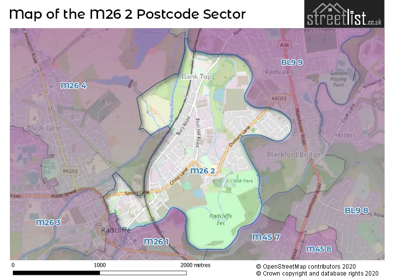
The M26 2 Postcode shares a border with BL8 2 (BURY), BL9 9 (BURY), M26 1 (Radcliffe), M26 4 (Radcliffe), BL9 8 (BURY, Unsworth), M26 3 (Radcliffe) and M45 7 (Whitefield).
The sector is within the post town of MANCHESTER.
M26 2 is a postcode sector within the M2 postcode district which is within the M Manchester postcode area.
The Royal Mail delivery office for the M26 2 postal sector is the Manchester Delivery Office.
The area of the M26 2 postcode sector is 1.05 square miles which is 2.72 square kilometres or 672.43 square acres.
Waterways within the M26 2 postcode sector include the Irwell, River Roch.

Map of the M26 2 Postcode Sector
Explore the M26 2 postcode sector by using our free interactive map.
| M | 2 | 6 | - | 2 | X | X |
| M | 2 | 6 | Space | 2 | Letter | Letter |
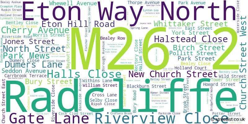
Official List of Streets
Radcliffe (118 Streets)
Unofficial Streets or Alternative Spellings
Radcliffe
ABDEN STREET MATHER STREET PARSONAGE STREET BAILLIE STREET CHEETHAM STREET CHURCH STREET CONEY GREEN TO WITHINS LANE PROW CROFT LANE CROOK STREET CROSS STREET CUNCLIFFE STREET CUNLIFFE STREET DURHAM STREET EDMUND STREET ETON WAY SOUTH GLEBE STREET GREY STREET HAGSIDE PROW HARDYS GATE HASSALL STREET HORROCKS STREET HUTCHINSON STREET LINLEY STREET LOWER WITHINS PATH NORMAN STREET OLIVE STREET PATH NW OF MONKEY BRIDGE QUARRY STREET RIVERSIDE WALK SPENCER STREET STORE STREET WITHINS LANE WHARF ACCESS LANE WRATH FOLD ROADWeather Forecast for M26 2
Press Button to Show Forecast for Radcliffe
| Time Period | Icon | Description | Temperature | Rain Probability | Wind |
|---|---|---|---|---|---|
| 06:00 to 09:00 | Partly cloudy (day) | 12.0°C (feels like 12.0°C) | 0.00% | NE 4 mph | |
| 09:00 to 12:00 | Cloudy | 14.0°C (feels like 13.0°C) | 4.00% | ENE 9 mph | |
| 12:00 to 15:00 | Cloudy | 16.0°C (feels like 15.0°C) | 8.00% | E 7 mph | |
| 15:00 to 18:00 | Cloudy | 17.0°C (feels like 16.0°C) | 5.00% | E 4 mph | |
| 18:00 to 21:00 | Partly cloudy (day) | 17.0°C (feels like 16.0°C) | 0.00% | E 7 mph | |
| 21:00 to 00:00 | Partly cloudy (night) | 14.0°C (feels like 14.0°C) | 0.00% | E 4 mph |
Press Button to Show Forecast for Radcliffe
| Time Period | Icon | Description | Temperature | Rain Probability | Wind |
|---|---|---|---|---|---|
| 00:00 to 03:00 | Partly cloudy (night) | 12.0°C (feels like 11.0°C) | 0.00% | ESE 4 mph | |
| 03:00 to 06:00 | Cloudy | 11.0°C (feels like 11.0°C) | 3.00% | ESE 2 mph | |
| 06:00 to 09:00 | Cloudy | 11.0°C (feels like 11.0°C) | 4.00% | SE 2 mph | |
| 09:00 to 12:00 | Cloudy | 14.0°C (feels like 13.0°C) | 4.00% | S 7 mph | |
| 12:00 to 15:00 | Cloudy | 17.0°C (feels like 16.0°C) | 5.00% | SSW 7 mph | |
| 15:00 to 18:00 | Cloudy | 18.0°C (feels like 17.0°C) | 12.00% | W 7 mph | |
| 18:00 to 21:00 | Cloudy | 16.0°C (feels like 15.0°C) | 5.00% | NW 7 mph | |
| 21:00 to 00:00 | Cloudy | 13.0°C (feels like 13.0°C) | 5.00% | NNW 4 mph |
Press Button to Show Forecast for Radcliffe
| Time Period | Icon | Description | Temperature | Rain Probability | Wind |
|---|---|---|---|---|---|
| 00:00 to 03:00 | Cloudy | 13.0°C (feels like 12.0°C) | 5.00% | NNW 2 mph | |
| 03:00 to 06:00 | Cloudy | 12.0°C (feels like 12.0°C) | 6.00% | WSW 2 mph | |
| 06:00 to 09:00 | Cloudy | 12.0°C (feels like 12.0°C) | 6.00% | SW 2 mph | |
| 09:00 to 12:00 | Cloudy | 15.0°C (feels like 15.0°C) | 5.00% | W 4 mph | |
| 12:00 to 15:00 | Cloudy | 17.0°C (feels like 17.0°C) | 4.00% | WNW 7 mph | |
| 15:00 to 18:00 | Cloudy | 18.0°C (feels like 17.0°C) | 3.00% | WNW 7 mph | |
| 18:00 to 21:00 | Cloudy | 17.0°C (feels like 16.0°C) | 4.00% | NW 7 mph | |
| 21:00 to 00:00 | Cloudy | 14.0°C (feels like 13.0°C) | 4.00% | NNW 4 mph |
Press Button to Show Forecast for Radcliffe
| Time Period | Icon | Description | Temperature | Rain Probability | Wind |
|---|---|---|---|---|---|
| 00:00 to 03:00 | Cloudy | 12.0°C (feels like 12.0°C) | 4.00% | NNE 2 mph | |
| 03:00 to 06:00 | Cloudy | 11.0°C (feels like 11.0°C) | 4.00% | NE 2 mph | |
| 06:00 to 09:00 | Cloudy | 13.0°C (feels like 13.0°C) | 4.00% | E 2 mph | |
| 09:00 to 12:00 | Cloudy | 16.0°C (feels like 16.0°C) | 4.00% | SE 2 mph | |
| 12:00 to 15:00 | Cloudy | 19.0°C (feels like 19.0°C) | 4.00% | S 4 mph | |
| 15:00 to 18:00 | Cloudy | 20.0°C (feels like 20.0°C) | 6.00% | S 4 mph | |
| 18:00 to 21:00 | Cloudy | 20.0°C (feels like 19.0°C) | 8.00% | S 4 mph | |
| 21:00 to 00:00 | Cloudy | 16.0°C (feels like 16.0°C) | 6.00% | SE 4 mph |
Press Button to Show Forecast for Radcliffe
| Time Period | Icon | Description | Temperature | Rain Probability | Wind |
|---|---|---|---|---|---|
| 00:00 to 03:00 | Clear night | 14.0°C (feels like 14.0°C) | 1.00% | SSE 4 mph | |
| 03:00 to 06:00 | Clear night | 12.0°C (feels like 12.0°C) | 1.00% | E 2 mph | |
| 06:00 to 09:00 | Sunny day | 14.0°C (feels like 13.0°C) | 2.00% | ESE 4 mph | |
| 09:00 to 12:00 | Sunny day | 18.0°C (feels like 17.0°C) | 2.00% | SSE 4 mph | |
| 12:00 to 15:00 | Partly cloudy (day) | 20.0°C (feels like 19.0°C) | 3.00% | S 7 mph | |
| 15:00 to 18:00 | Partly cloudy (day) | 21.0°C (feels like 20.0°C) | 4.00% | S 9 mph | |
| 18:00 to 21:00 | Partly cloudy (day) | 20.0°C (feels like 19.0°C) | 4.00% | SSW 7 mph | |
| 21:00 to 00:00 | Clear night | 16.0°C (feels like 15.0°C) | 3.00% | SE 4 mph |
Schools and Places of Education Within the M26 2 Postcode Sector
Radcliffe Hall Church of England Methodist Primary School
Academy sponsor led
Bury Street, Manchester, , M26 2GB
Head: Mr Paul Wilson
Ofsted Rating: Good
Inspection: 2023-11-29 (160 days ago)
Website: Visit Radcliffe Hall Church of England Methodist Primary School Website
Phone: 01617244928
Number of Pupils: 292
House Prices in the M26 2 Postcode Sector
| Type of Property | 2018 Average | 2018 Sales | 2017 Average | 2017 Sales | 2016 Average | 2016 Sales | 2015 Average | 2015 Sales |
|---|---|---|---|---|---|---|---|---|
| Detached | £240,333 | 6 | £203,844 | 13 | £201,612 | 47 | £188,216 | 61 |
| Semi-Detached | £153,176 | 25 | £125,977 | 24 | £135,938 | 48 | £135,054 | 55 |
| Terraced | £102,815 | 86 | £90,286 | 63 | £85,077 | 74 | £83,156 | 65 |
| Flats | £69,833 | 3 | £92,499 | 7 | £68,594 | 8 | £60,901 | 11 |
Important Postcodes M26 2 in the Postcode Sector
M26 2DT is the postcode for Whittaker House, 7 Whittaker Street, Radcliffe, Bury Metropolitan Borough Council, 7 Whittaker Street, Radcliffe, and Bury Metropolitan Borough Council, 7 Whittaker Street
M26 2GB is the postcode for Radcliffe Hall C Of E Methodist Primary School, Bury Street, Radcliffe, and Radcliffe Hall C of E Methodist Primary School, Bury Street
M26 2QD is the postcode for Bealey Community Hospital, Dumers Lane
M26 2SP is the postcode for Radcliffe Primary Care Centre, 69 Church Street West, Radcliffe, and Radcliffe Primary Care Centre, 69 Church Street West
M26 2SQ is the postcode for Radcliffe Primary Care Centre, 69 Church Street West
M26 2SZ is the postcode for Radcliffe Leisure Centre, Spring Lane, Spring Lane School, Spring Lane, Spring Lane School, Spring Lane, Radcliffe, and Radcliffe Leisure Centre, Spring Lane, Radcliffe
M26 2TD is the postcode for Whittaker House, 40 Whittaker Street
M26 2UH is the postcode for Radcliffe Civic Hall, Thomas Street
| The M26 2 Sector is within these Local Authorities |
|
|---|---|
| The M26 2 Sector is within these Counties |
|
| The M26 2 Sector is within these Water Company Areas |
|