The M45 7 postcode sector is within the county of Greater Manchester.
Did you know? According to the 2021 Census, the M45 7 postcode sector is home to a bustling 9,145 residents!
Given that each sector allows for 400 unique postcode combinations. Letters C, I, K, M, O and V are not allowed in the last two letters of a postcode. With 269 postcodes already in use, this leaves 131 units available.
The M45 7 postal code covers the settlement of Whitefield.
The M45 7 Postcode shares a border with M25 3 (Prestwich), M25 9 (Prestwich), M26 1 (Radcliffe), M26 2 (Radcliffe), M27 6 (Swinton), BL9 8 (BURY, Unsworth), M27 8 (Swinton), M45 6 (Whitefield) and M45 8 (Whitefield).
The sector is within the post town of MANCHESTER.
M45 7 is a postcode sector within the M45 postcode district which is within the M Manchester postcode area.
The Royal Mail delivery office for the M45 7 postal sector is the Prestwich Delivery Office.
The area of the M45 7 postcode sector is 2.57 square miles which is 6.65 square kilometres or 1,642.93 square acres.
The M45 7 postcode sector is crossed by the M60 motorway.
Waterways within the M45 7 postcode sector include the Irwell, River Irwell, Manchester, Bolton and Bury Canal.

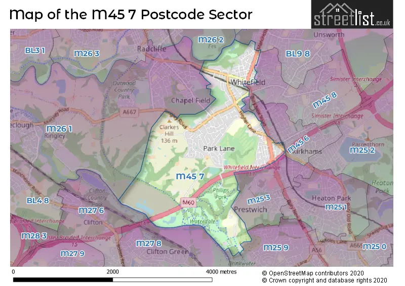
Map of the M45 7 Postcode Sector
Explore the M45 7 postcode sector by using our free interactive map.
| M | 4 | 5 | - | 7 | X | X |
| M | 4 | 5 | Space | 7 | Letter | Letter |
Official List of Streets
Whitefield (152 Streets)
Unofficial Streets or Alternative Spellings
Whitefield
CLEGG STREET GROSVENOR ROAD HOLLY FOLD MAYFAIR AVENUE RUFFORD DRIVE SELBY AVENUE THATCH LEACH LANE AGECROFT ROAD BARN STREET BLUE ROUTE BLUE ROUTE - RED SECTION BLUE ROUTE LINK CIRCULAR WALK CLIFTON AQUEDUCT CLOUGH DEAN CLOSE FAIRHAVEN CLOSE LOMAX STREET NORTH VEIW OUTWOOD TRAIL PHILIPS PARK ROAD PRESTWICH FOOTBRIDGE RED ROUTE REDCOT DRIVE RYE CROFT SPRINGWATER LANE THE PADDOCK THE SQUARE TOP O TH FIELDS TOTTINGTON LANE TOWPATH WHITEFIELD INTERCHANGERadcliffe
RADCLIFFE NEW ROAD STAND LANEPrestwich
BURY NEW ROAD BURY OLD ROAD CLIFTON ROADBURY
MANCHESTER ROAD MIDDLETON DRIVEWeather Forecast for M45 7
Press Button to Show Forecast for Chapel Field
| Time Period | Icon | Description | Temperature | Rain Probability | Wind |
|---|---|---|---|---|---|
| 15:00 to 18:00 | Cloudy | 22.0°C (feels like 19.0°C) | 3.00% | SE 11 mph | |
| 18:00 to 21:00 | Cloudy | 21.0°C (feels like 19.0°C) | 3.00% | SE 9 mph | |
| 21:00 to 00:00 | Cloudy | 18.0°C (feels like 16.0°C) | 3.00% | ESE 9 mph |
Press Button to Show Forecast for Chapel Field
| Time Period | Icon | Description | Temperature | Rain Probability | Wind |
|---|---|---|---|---|---|
| 00:00 to 03:00 | Cloudy | 15.0°C (feels like 14.0°C) | 3.00% | E 7 mph | |
| 03:00 to 06:00 | Cloudy | 13.0°C (feels like 12.0°C) | 3.00% | ENE 7 mph | |
| 06:00 to 09:00 | Cloudy | 14.0°C (feels like 12.0°C) | 4.00% | ENE 9 mph | |
| 09:00 to 12:00 | Cloudy | 18.0°C (feels like 16.0°C) | 3.00% | E 9 mph | |
| 12:00 to 15:00 | Cloudy | 22.0°C (feels like 20.0°C) | 9.00% | SE 11 mph | |
| 15:00 to 18:00 | Cloudy | 22.0°C (feels like 20.0°C) | 35.00% | SE 11 mph | |
| 18:00 to 21:00 | Light rain shower (day) | 21.0°C (feels like 19.0°C) | 40.00% | SE 9 mph | |
| 21:00 to 00:00 | Cloudy | 18.0°C (feels like 17.0°C) | 33.00% | E 7 mph |
Press Button to Show Forecast for Chapel Field
| Time Period | Icon | Description | Temperature | Rain Probability | Wind |
|---|---|---|---|---|---|
| 00:00 to 03:00 | Light rain shower (night) | 16.0°C (feels like 15.0°C) | 33.00% | SE 7 mph | |
| 03:00 to 06:00 | Partly cloudy (night) | 14.0°C (feels like 14.0°C) | 10.00% | SE 4 mph | |
| 06:00 to 09:00 | Cloudy | 14.0°C (feels like 13.0°C) | 13.00% | SSE 7 mph | |
| 09:00 to 12:00 | Cloudy | 16.0°C (feels like 14.0°C) | 13.00% | S 9 mph | |
| 12:00 to 15:00 | Cloudy | 18.0°C (feels like 15.0°C) | 16.00% | S 11 mph | |
| 15:00 to 18:00 | Cloudy | 18.0°C (feels like 15.0°C) | 20.00% | SSE 13 mph | |
| 18:00 to 21:00 | Light rain | 16.0°C (feels like 14.0°C) | 54.00% | SE 11 mph | |
| 21:00 to 00:00 | Light rain | 14.0°C (feels like 13.0°C) | 58.00% | SE 11 mph |
Press Button to Show Forecast for Chapel Field
| Time Period | Icon | Description | Temperature | Rain Probability | Wind |
|---|---|---|---|---|---|
| 00:00 to 03:00 | Light rain | 14.0°C (feels like 12.0°C) | 58.00% | SE 9 mph | |
| 03:00 to 06:00 | Light rain | 13.0°C (feels like 12.0°C) | 50.00% | SE 9 mph | |
| 06:00 to 09:00 | Light rain | 13.0°C (feels like 12.0°C) | 54.00% | SE 7 mph | |
| 09:00 to 12:00 | Cloudy | 14.0°C (feels like 13.0°C) | 24.00% | SE 9 mph | |
| 12:00 to 15:00 | Light rain shower (day) | 16.0°C (feels like 14.0°C) | 43.00% | SSE 11 mph | |
| 15:00 to 18:00 | Heavy rain shower (day) | 17.0°C (feels like 15.0°C) | 58.00% | SSE 11 mph | |
| 18:00 to 21:00 | Light rain shower (day) | 16.0°C (feels like 14.0°C) | 40.00% | SSE 9 mph | |
| 21:00 to 00:00 | Light rain shower (night) | 14.0°C (feels like 12.0°C) | 33.00% | SSE 9 mph |
Press Button to Show Forecast for Chapel Field
| Time Period | Icon | Description | Temperature | Rain Probability | Wind |
|---|---|---|---|---|---|
| 00:00 to 03:00 | Partly cloudy (night) | 13.0°C (feels like 11.0°C) | 8.00% | SSE 9 mph | |
| 03:00 to 06:00 | Partly cloudy (night) | 12.0°C (feels like 10.0°C) | 6.00% | SE 9 mph | |
| 06:00 to 09:00 | Partly cloudy (day) | 12.0°C (feels like 10.0°C) | 6.00% | SE 9 mph | |
| 09:00 to 12:00 | Partly cloudy (day) | 14.0°C (feels like 12.0°C) | 11.00% | SSE 11 mph | |
| 12:00 to 15:00 | Light rain shower (day) | 16.0°C (feels like 14.0°C) | 36.00% | SSE 11 mph | |
| 15:00 to 18:00 | Light rain shower (day) | 17.0°C (feels like 15.0°C) | 36.00% | S 11 mph | |
| 18:00 to 21:00 | Light rain shower (day) | 16.0°C (feels like 14.0°C) | 39.00% | S 9 mph | |
| 21:00 to 00:00 | Clear night | 14.0°C (feels like 13.0°C) | 10.00% | SSE 7 mph |
Schools and Places of Education Within the M45 7 Postcode Sector
Higher Lane Primary School
Academy converter
Egerton Road, Manchester, , M45 7EX
Head: Mr Ian Tetlow
Ofsted Rating: Good
Inspection: 2021-11-17 (906 days ago)
Website: Visit Higher Lane Primary School Website
Phone: 01617662005
Number of Pupils: 456
Philips High School
Community school
Higher Lane, Manchester, , M45 7PH
Head: Ms T J Owen
Ofsted Rating: Requires improvement
Inspection: 2022-06-15 (696 days ago)
Website: Visit Philips High School Website
Phone: 01613512200
Number of Pupils: 882
House Prices in the M45 7 Postcode Sector
| Type of Property | 2018 Average | 2018 Sales | 2017 Average | 2017 Sales | 2016 Average | 2016 Sales | 2015 Average | 2015 Sales |
|---|---|---|---|---|---|---|---|---|
| Detached | £513,665 | 47 | £453,239 | 56 | £424,515 | 49 | £413,116 | 51 |
| Semi-Detached | £230,168 | 64 | £190,863 | 66 | £234,546 | 57 | £183,699 | 69 |
| Terraced | £185,449 | 41 | £212,238 | 39 | £195,714 | 44 | £161,417 | 47 |
| Flats | £189,350 | 37 | £245,613 | 31 | £142,780 | 23 | £129,780 | 28 |
Important Postcodes M45 7 in the Postcode Sector
M45 7EX is the postcode for Higher Lane Primary School, Egerton Road, Whitefield, and Higher Lane Primary School, Egerton Road
M45 7NY is the postcode for Whitfield Library, Pinfold Lane, and Pinfold Lane Day Care Centre, Pinfold Lane
M45 7PH is the postcode for MAIN BUILDING, Philips High School, Higher Lane, Philips High School, Higher Lane, and SPORTS HALL, Philips High School, Higher Lane
M45 7SY is the postcode for Greater Manchester Fire & Rescue Service, Fire Station, Bury New Road
M45 7TA is the postcode for Elms Square, Elms Sqaure, and Total Fitness 2010 Limited, Elms Square
| The M45 7 Sector is within these Local Authorities |
|
|---|---|
| The M45 7 Sector is within these Counties |
|
| The M45 7 Sector is within these Water Company Areas |
|