The M20 5 postcode sector is within the county of Greater Manchester.
Did you know? According to the 2021 Census, the M20 5 postcode sector is home to a bustling 4,701 residents!
Given that each sector allows for 400 unique postcode combinations. Letters C, I, K, M, O and V are not allowed in the last two letters of a postcode. With 99 postcodes already in use, this leaves 301 units available.
The M20 5 postal code covers the settlement of MANCHESTER.
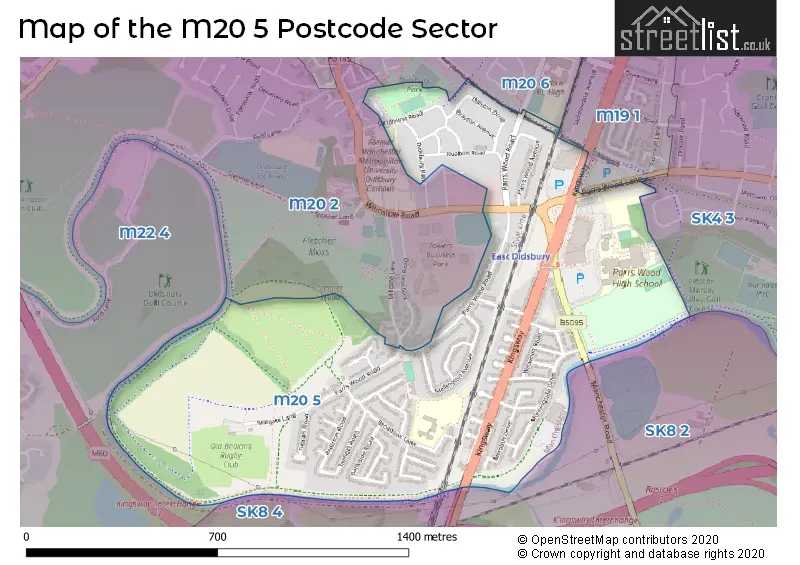
The M20 5 Postcode shares a border with M19 1 (MANCHESTER), M20 2 (MANCHESTER, Didsbury), M22 4 (MANCHESTER, Sharston Industrial Area, Northenden), SK4 3 (STOCKPORT, Heaton Mersey), SK8 2 (CHEADLE), SK8 4 (Gatley) and M20 6 (MANCHESTER).
The sector is within the post town of MANCHESTER.
M20 5 is a postcode sector within the M20 postcode district which is within the M Manchester postcode area.
The Royal Mail delivery office for the M20 5 postal sector is the Manchester South Delivery Office.
The area of the M20 5 postcode sector is 0.62 square miles which is 1.60 square kilometres or 394.48 square acres.
Waterways within the M20 5 postcode sector include the River Mersey, Micker Brook.

Map of the M20 5 Postcode Sector
Explore the M20 5 postcode sector by using our free interactive map.
| M | 2 | 0 | - | 5 | X | X |
| M | 2 | 0 | Space | 5 | Letter | Letter |
Official List of Streets
MANCHESTER (48 Streets)
Unofficial Streets or Alternative Spellings
MANCHESTER
WINGATE DRIVECHEADLE
MANCHESTER ROADGatley
KINGSWAYDidsbury
WILMSLOW ROAD BROADOAK LANE DRAYTON MANORSchools and Places of Education Within the M20 5 Postcode Sector
Broad Oak Primary School
Community school
Broad Oak Lane, Manchester, Greater Manchester, M20 5QB
Head: Mr Kevin Corteen
Ofsted Rating: Requires improvement
Inspection: 2022-03-30 (800 days ago)
Website: Visit Broad Oak Primary School Website
Phone: 01614456577
Number of Pupils: 408
Parrs Wood High School
Academy converter
Wilmslow Road, Manchester, , M20 5PG
Head: Mr Mark McElwee
Ofsted Rating: Good
Inspection: 2019-05-16 (1849 days ago)
Website: Visit Parrs Wood High School Website
Phone: 01614468640
Number of Pupils: 1923
House Prices in the M20 5 Postcode Sector
| Type of Property | 2018 Average | 2018 Sales | 2017 Average | 2017 Sales | 2016 Average | 2016 Sales | 2015 Average | 2015 Sales |
|---|---|---|---|---|---|---|---|---|
| Detached | £1,028,464 | 7 | £596,200 | 5 | £402,071 | 7 | £305,000 | 3 |
| Semi-Detached | £317,714 | 46 | £329,083 | 53 | £284,919 | 39 | £261,390 | 60 |
| Terraced | £268,500 | 1 | £277,139 | 9 | £263,600 | 5 | £329,500 | 2 |
| Flats | £226,329 | 12 | £197,625 | 12 | £155,395 | 22 | £180,160 | 17 |
Important Postcodes M20 5 in the Postcode Sector
M20 5PG is the postcode for SPORTS HALL, Parrs Wood High School, Wilmslow Road, PARRS WOOD HOUSE, Parrs Wood High School, Wilmslow Road, Parrs Wood High School, Wilmslow Road, and MAIN BUILDING, Parrs Wood High School, Wilmslow Road
M20 5QB is the postcode for Broad Oak Primary School, Broad Oak Lane, and MAIN SCHOOL, Broad Oak Primary School, Broad Oak Lane
| The M20 5 Sector is within these Local Authorities |
|
|---|---|
| The M20 5 Sector is within these Counties |
|
| The M20 5 Sector is within these Water Company Areas |
|