The M22 4 postcode sector is within the county of Greater Manchester.
Did you know? According to the 2021 Census, the M22 4 postcode sector is home to a bustling 10,836 residents!
Given that each sector allows for 400 unique postcode combinations. Letters C, I, K, M, O and V are not allowed in the last two letters of a postcode. With 304 postcodes already in use, this leaves 96 units available.
The largest settlement in the M22 4 postal code is MANCHESTER followed by Sharston Industrial Area, and Northenden.
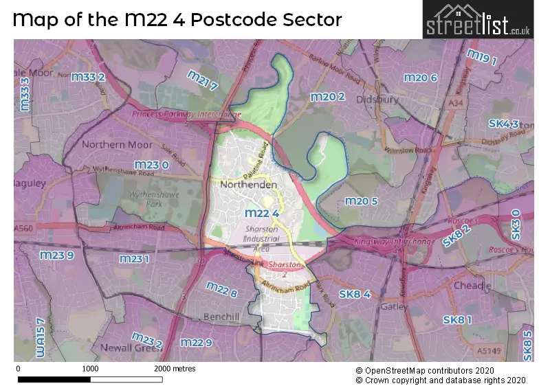
The M22 4 Postcode shares a border with M20 2 (MANCHESTER, Didsbury), M21 7 (MANCHESTER, Chorlton Cum Hardy), M22 5 (MANCHESTER, Wythenshawe), M23 0 (MANCHESTER, Wythenshawe), SK8 4 (Gatley), M20 5 (MANCHESTER), M22 8 (MANCHESTER, Wythenshawe), M22 9 (MANCHESTER, Wythenshawe) and M23 1 (MANCHESTER).
The sector is within the post town of MANCHESTER.
M22 4 is a postcode sector within the M22 postcode district which is within the M Manchester postcode area.
The Royal Mail delivery office for the M22 4 postal sector is the Wythenshawe Delivery Office.
The area of the M22 4 postcode sector is 1.59 square miles which is 4.13 square kilometres or 1,020.11 square acres.
The M22 4 postcode sector is crossed by the M56 motorway.
The M22 4 postcode sector is crossed by the M60 motorway.
The M22 4 postcode sector is crossed by the A5103 Major A road.
Waterways within the M22 4 postcode sector include the River Mersey.

Map of the M22 4 Postcode Sector
Explore the M22 4 postcode sector by using our free interactive map.
| M | 2 | 2 | - | 4 | X | X |
| M | 2 | 2 | Space | 4 | Letter | Letter |
Official List of Streets
MANCHESTER (131 Streets)
Northenden (6 Streets)
Sharston Industrial Area (9 Streets)
Wythenshawe (1 Streets)
Unofficial Streets or Alternative Spellings
Gatley
ALTRINCHAM ROAD HOLLYHEDGE ROAD OGDEN GROVE ORCHARD GARDENS PARK ROAD ROSEWOOD GARDENS STYAL ROADMANCHESTER
CROSSACRES ROAD LONGHEY ROAD MAYFAIR ROAD SOLWAY ROAD WYTHENSHAWE ROAD CARRSFIELD ROAD CHANDLER CLOSE DUKEFIELD STREET HOMEWOOD AVENUE PIPERHILL AVENUE PRINCESS PARKWAY ROYAL GREEN ROAD SHARSTON INTERCHANGE SHARSTON LINK SIMONS BRIDGE TATTON ARMS BRIDGEWythenshawe
BROWNLEY COURT ROAD ROYALTHORN ROADDidsbury
FORD LANEWeather Forecast for M22 4
Press Button to Show Forecast for Sharston
| Time Period | Icon | Description | Temperature | Rain Probability | Wind |
|---|---|---|---|---|---|
| 03:00 to 06:00 | Cloudy | 5.0°C (feels like 3.0°C) | 5.00% | NE 4 mph | |
| 06:00 to 09:00 | Cloudy | 5.0°C (feels like 3.0°C) | 5.00% | NE 7 mph | |
| 09:00 to 12:00 | Cloudy | 8.0°C (feels like 6.0°C) | 6.00% | ENE 9 mph | |
| 12:00 to 15:00 | Cloudy | 10.0°C (feels like 8.0°C) | 14.00% | ESE 9 mph | |
| 15:00 to 18:00 | Light rain | 9.0°C (feels like 7.0°C) | 49.00% | ENE 9 mph | |
| 18:00 to 21:00 | Cloudy | 9.0°C (feels like 7.0°C) | 9.00% | ENE 9 mph | |
| 21:00 to 00:00 | Cloudy | 7.0°C (feels like 5.0°C) | 5.00% | NE 7 mph |
Press Button to Show Forecast for Sharston
| Time Period | Icon | Description | Temperature | Rain Probability | Wind |
|---|---|---|---|---|---|
| 00:00 to 03:00 | Cloudy | 6.0°C (feels like 4.0°C) | 4.00% | NNE 7 mph | |
| 03:00 to 06:00 | Cloudy | 6.0°C (feels like 3.0°C) | 7.00% | N 7 mph | |
| 06:00 to 09:00 | Cloudy | 6.0°C (feels like 3.0°C) | 14.00% | N 7 mph | |
| 09:00 to 12:00 | Light rain | 7.0°C (feels like 5.0°C) | 46.00% | NNW 7 mph | |
| 12:00 to 15:00 | Light rain | 9.0°C (feels like 7.0°C) | 46.00% | NW 9 mph | |
| 15:00 to 18:00 | Cloudy | 10.0°C (feels like 8.0°C) | 13.00% | WNW 11 mph | |
| 18:00 to 21:00 | Sunny day | 10.0°C (feels like 8.0°C) | 5.00% | W 9 mph | |
| 21:00 to 00:00 | Clear night | 7.0°C (feels like 5.0°C) | 3.00% | SW 7 mph |
Press Button to Show Forecast for Sharston
| Time Period | Icon | Description | Temperature | Rain Probability | Wind |
|---|---|---|---|---|---|
| 00:00 to 03:00 | Partly cloudy (night) | 6.0°C (feels like 3.0°C) | 1.00% | SSW 7 mph | |
| 03:00 to 06:00 | Partly cloudy (night) | 4.0°C (feels like 2.0°C) | 2.00% | SSE 7 mph | |
| 06:00 to 09:00 | Partly cloudy (day) | 6.0°C (feels like 3.0°C) | 3.00% | SSE 7 mph | |
| 09:00 to 12:00 | Partly cloudy (day) | 10.0°C (feels like 8.0°C) | 2.00% | S 11 mph | |
| 12:00 to 15:00 | Overcast | 13.0°C (feels like 10.0°C) | 11.00% | S 13 mph | |
| 15:00 to 18:00 | Overcast | 14.0°C (feels like 11.0°C) | 11.00% | S 13 mph | |
| 18:00 to 21:00 | Cloudy | 13.0°C (feels like 11.0°C) | 10.00% | S 11 mph | |
| 21:00 to 00:00 | Clear night | 11.0°C (feels like 8.0°C) | 3.00% | SSE 9 mph |
Press Button to Show Forecast for Sharston
| Time Period | Icon | Description | Temperature | Rain Probability | Wind |
|---|---|---|---|---|---|
| 00:00 to 03:00 | Partly cloudy (night) | 9.0°C (feels like 7.0°C) | 3.00% | SE 9 mph | |
| 03:00 to 06:00 | Partly cloudy (night) | 8.0°C (feels like 6.0°C) | 2.00% | SE 9 mph | |
| 06:00 to 09:00 | Sunny day | 9.0°C (feels like 6.0°C) | 3.00% | ESE 9 mph | |
| 09:00 to 12:00 | Sunny day | 13.0°C (feels like 10.0°C) | 4.00% | ESE 11 mph | |
| 12:00 to 15:00 | Partly cloudy (day) | 15.0°C (feels like 12.0°C) | 8.00% | SE 13 mph | |
| 15:00 to 18:00 | Cloudy | 16.0°C (feels like 14.0°C) | 11.00% | SE 13 mph | |
| 18:00 to 21:00 | Partly cloudy (day) | 15.0°C (feels like 13.0°C) | 8.00% | ESE 11 mph | |
| 21:00 to 00:00 | Cloudy | 13.0°C (feels like 11.0°C) | 6.00% | ESE 9 mph |
Schools and Places of Education Within the M22 4 Postcode Sector
Northenden Community School
Community school
Bazley Road, Manchester, , M22 4FL
Head: Mrs Allison Collis
Ofsted Rating: Good
Inspection: 2019-10-23 (1648 days ago)
Website: Visit Northenden Community School Website
Phone: 01619984825
Number of Pupils: 231
Southern Cross School
Community special school
Roundwood Road, Manchester, , M22 4AB
Head: Mrs Kate Burke
Ofsted Rating: Good
Inspection: 2023-09-27 (213 days ago)
Website: Visit Southern Cross School Website
Phone: 01618812695
Number of Pupils: 129
St Wilfrid's CofE Aided Primary School Northenden
Academy sponsor led
Patterdale Road, Manchester, , M22 4NR
Head: Mrs Helena Miller
Ofsted Rating: Good
Inspection: 2019-03-06 (1879 days ago)
Website: Visit St Wilfrid's CofE Aided Primary School Northenden Website
Phone: 01619983663
Number of Pupils: 339
House Prices in the M22 4 Postcode Sector
| Type of Property | 2018 Average | 2018 Sales | 2017 Average | 2017 Sales | 2016 Average | 2016 Sales | 2015 Average | 2015 Sales |
|---|---|---|---|---|---|---|---|---|
| Detached | £312,640 | 21 | £294,073 | 18 | £304,737 | 19 | £312,714 | 14 |
| Semi-Detached | £233,086 | 81 | £214,208 | 83 | £210,898 | 81 | £212,543 | 73 |
| Terraced | £180,638 | 64 | £189,673 | 66 | £193,502 | 98 | £165,658 | 89 |
| Flats | £130,237 | 43 | £140,987 | 92 | £111,938 | 62 | £114,117 | 41 |
Important Postcodes M22 4 in the Postcode Sector
M22 4DH is the postcode for Manchester Primary Care Trust, Northenden Health Centre, Mancunian Community Health N H S Trust, Northenden Health Centre, 489 Palatine Road, and NORTHENDEN HEALTH CENTRE, 489 PALATINE ROAD, MANCHESTER
M22 4DJ is the postcode for Parkway Green Housing, Parkway Green House, Palatine Road
M22 4FL is the postcode for MAIN SCHOOL, Northenden Community School, Bazley Road, and Northenden Community School, Bazley Road
M22 4GA is the postcode for Brownley Green Health Centre, Brownley Road, Brownley Green Health Centre, Brownley Road, Wythenshaw, and Brownley Green Medical Centre, Brownley Road
M22 4HY is the postcode for Manchester Social Services, Oakwood Lodge, 177 Longley Lane
M22 4JG is the postcode for The Longmire Centre, 181 Longley Lane
M22 4NR is the postcode for St. Wilfrids C of E Primary School, Patterdale Road, MAIN BUILDING, St. Wilfrids C of E Primary School, Patterdale Road, and NURSERY BUILDING, St. Wilfrids C of E Primary School, Patterdale Road
M22 4PJ is the postcode for Wythenshawe Health Care Centre, Stancliffe Road
M22 4RQ is the postcode for Manchester City Council, Longley Lane
M22 4UN is the postcode for The Open University, 351 Altrincham Road
| The M22 4 Sector is within these Local Authorities |
|
|---|---|
| The M22 4 Sector is within these Counties |
|
| The M22 4 Sector is within these Water Company Areas |
|