The M22 8 postcode sector is within the county of Greater Manchester.
Did you know? According to the 2021 Census, the M22 8 postcode sector is home to a bustling 5,735 residents!
Given that each sector allows for 400 unique postcode combinations. Letters C, I, K, M, O and V are not allowed in the last two letters of a postcode. With 149 postcodes already in use, this leaves 251 units available.
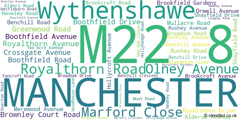
The largest settlements in the M22 8 postal code are MANCHESTER and Wythenshawe.
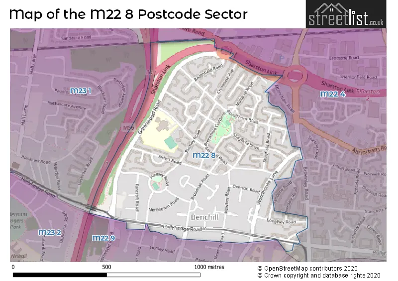
The M22 8 Postcode shares a border with M22 4 (MANCHESTER, Sharston Industrial Area, Northenden), M23 0 (MANCHESTER, Wythenshawe), M22 9 (MANCHESTER, Wythenshawe), M23 1 (MANCHESTER) and M23 2 (MANCHESTER).
The sector is within the post town of MANCHESTER.
M22 8 is a postcode sector within the M22 postcode district which is within the M Manchester postcode area.
The Royal Mail delivery office for the M22 8 postal sector is the Wythenshawe Delivery Office.
The area of the M22 8 postcode sector is 0.33 square miles which is 0.85 square kilometres or 211.10 square acres.
The M22 8 postcode sector is crossed by the M56 motorway.

Map of the M22 8 Postcode Sector
Explore the M22 8 postcode sector by using our free interactive map.
| M | 2 | 2 | - | 8 | X | X |
| M | 2 | 2 | Space | 8 | Letter | Letter |
Official List of Streets
MANCHESTER (50 Streets)
Unofficial Streets or Alternative Spellings
Weather Forecast for M22 8
Press Button to Show Forecast for Wythenshawe
| Time Period | Icon | Description | Temperature | Rain Probability | Wind |
|---|---|---|---|---|---|
| 12:00 to 15:00 | Cloudy | 20.0°C (feels like 21.0°C) | 4.00% | SSW 2 mph | |
| 15:00 to 18:00 | Cloudy | 22.0°C (feels like 22.0°C) | 3.00% | SE 2 mph | |
| 18:00 to 21:00 | Cloudy | 22.0°C (feels like 21.0°C) | 3.00% | SE 4 mph | |
| 21:00 to 00:00 | Partly cloudy (night) | 18.0°C (feels like 18.0°C) | 1.00% | ESE 7 mph |
Press Button to Show Forecast for Wythenshawe
| Time Period | Icon | Description | Temperature | Rain Probability | Wind |
|---|---|---|---|---|---|
| 00:00 to 03:00 | Cloudy | 16.0°C (feels like 16.0°C) | 3.00% | SE 4 mph | |
| 03:00 to 06:00 | Cloudy | 15.0°C (feels like 15.0°C) | 4.00% | E 4 mph | |
| 06:00 to 09:00 | Cloudy | 16.0°C (feels like 15.0°C) | 3.00% | E 4 mph | |
| 09:00 to 12:00 | Partly cloudy (day) | 19.0°C (feels like 19.0°C) | 0.00% | SSE 4 mph | |
| 12:00 to 15:00 | Cloudy | 21.0°C (feels like 20.0°C) | 3.00% | SE 9 mph | |
| 15:00 to 18:00 | Cloudy | 22.0°C (feels like 20.0°C) | 4.00% | SSE 9 mph | |
| 18:00 to 21:00 | Cloudy | 21.0°C (feels like 20.0°C) | 3.00% | SE 9 mph | |
| 21:00 to 00:00 | Cloudy | 18.0°C (feels like 16.0°C) | 3.00% | ESE 9 mph |
Press Button to Show Forecast for Wythenshawe
| Time Period | Icon | Description | Temperature | Rain Probability | Wind |
|---|---|---|---|---|---|
| 00:00 to 03:00 | Cloudy | 16.0°C (feels like 15.0°C) | 4.00% | ESE 9 mph | |
| 03:00 to 06:00 | Cloudy | 14.0°C (feels like 13.0°C) | 4.00% | E 7 mph | |
| 06:00 to 09:00 | Cloudy | 15.0°C (feels like 14.0°C) | 3.00% | E 4 mph | |
| 09:00 to 12:00 | Cloudy | 18.0°C (feels like 17.0°C) | 4.00% | ESE 7 mph | |
| 12:00 to 15:00 | Cloudy | 21.0°C (feels like 19.0°C) | 9.00% | SE 9 mph | |
| 15:00 to 18:00 | Light rain shower (day) | 21.0°C (feels like 19.0°C) | 38.00% | SSE 11 mph | |
| 18:00 to 21:00 | Heavy rain shower (day) | 18.0°C (feels like 18.0°C) | 57.00% | S 7 mph | |
| 21:00 to 00:00 | Light rain shower (night) | 16.0°C (feels like 16.0°C) | 36.00% | SSE 7 mph |
Press Button to Show Forecast for Wythenshawe
| Time Period | Icon | Description | Temperature | Rain Probability | Wind |
|---|---|---|---|---|---|
| 00:00 to 03:00 | Partly cloudy (night) | 15.0°C (feels like 14.0°C) | 13.00% | SSE 4 mph | |
| 03:00 to 06:00 | Partly cloudy (night) | 14.0°C (feels like 13.0°C) | 10.00% | SSE 4 mph | |
| 06:00 to 09:00 | Cloudy | 14.0°C (feels like 13.0°C) | 12.00% | SSE 7 mph | |
| 09:00 to 12:00 | Cloudy | 15.0°C (feels like 14.0°C) | 15.00% | SSE 9 mph | |
| 12:00 to 15:00 | Light rain shower (day) | 17.0°C (feels like 15.0°C) | 42.00% | SSE 11 mph | |
| 15:00 to 18:00 | Heavy rain | 17.0°C (feels like 14.0°C) | 77.00% | SSE 11 mph | |
| 18:00 to 21:00 | Heavy rain | 15.0°C (feels like 14.0°C) | 81.00% | SSE 11 mph | |
| 21:00 to 00:00 | Heavy rain | 14.0°C (feels like 12.0°C) | 77.00% | SSE 9 mph |
Press Button to Show Forecast for Wythenshawe
| Time Period | Icon | Description | Temperature | Rain Probability | Wind |
|---|---|---|---|---|---|
| 00:00 to 03:00 | Light rain | 13.0°C (feels like 11.0°C) | 52.00% | SSE 9 mph | |
| 03:00 to 06:00 | Cloudy | 12.0°C (feels like 10.0°C) | 17.00% | SE 9 mph | |
| 06:00 to 09:00 | Cloudy | 12.0°C (feels like 10.0°C) | 8.00% | SSE 9 mph | |
| 09:00 to 12:00 | Light rain shower (day) | 14.0°C (feels like 12.0°C) | 34.00% | SSE 11 mph | |
| 12:00 to 15:00 | Light rain shower (day) | 16.0°C (feels like 13.0°C) | 38.00% | SSE 13 mph | |
| 15:00 to 18:00 | Light rain shower (day) | 16.0°C (feels like 13.0°C) | 40.00% | SSE 13 mph | |
| 18:00 to 21:00 | Light rain shower (day) | 15.0°C (feels like 13.0°C) | 37.00% | SSE 11 mph | |
| 21:00 to 00:00 | Light rain shower (night) | 13.0°C (feels like 11.0°C) | 30.00% | SSE 9 mph |
Schools and Places of Education Within the M22 8 Postcode Sector
Benchill Primary School
Foundation school
Benchill Road, Manchester, , M22 8EJ
Head: Helen Eken Stuart
Ofsted Rating: Good
Inspection: 2019-09-12 (1702 days ago)
Website: Visit Benchill Primary School Website
Phone: 01619983075
Number of Pupils: 550
House Prices in the M22 8 Postcode Sector
| Type of Property | 2018 Average | 2018 Sales | 2017 Average | 2017 Sales | 2016 Average | 2016 Sales | 2015 Average | 2015 Sales |
|---|---|---|---|---|---|---|---|---|
| Detached | £0 | 0 | £0 | 0 | £0 | 0 | £133,500 | 1 |
| Semi-Detached | £134,548 | 20 | £127,021 | 21 | £113,474 | 20 | £93,200 | 5 |
| Terraced | £130,615 | 13 | £110,864 | 11 | £110,042 | 20 | £106,032 | 14 |
| Flats | £107,795 | 11 | £96,600 | 5 | £84,156 | 8 | £84,250 | 8 |
Important Postcodes M22 8 in the Postcode Sector
M22 8EJ is the postcode for Benchill Primary School, Benchill Road, Benchill Community Centre, Benchill Road, and NEW BUILD, Benchill Primary School, Benchill Road
M22 8LF is the postcode for Benchill Neighbourhood Office, 34 Benchill Road, and The Enterprise Centre, 34 Benchill Road
| The M22 8 Sector is within these Local Authorities |
|
|---|---|
| The M22 8 Sector is within these Counties |
|
| The M22 8 Sector is within these Water Company Areas |
|