The M28 postcode district is a postal district located in the M Manchester postcode area with a population of 43,560 residents according to the 2021 England and Wales Census.
The area of the M28 postcode district is 9.60 square miles which is 24.85 square kilometres or 6,141.30 acres.
Currently, the M28 district has about 1077 postcode units spread across 5 geographic postcode sectors.
Given that each sector allows for 400 unique postcode combinations, the district has a capacity of 2,000 postcodes. With 1077 postcodes already in use, this leaves 923 units available.
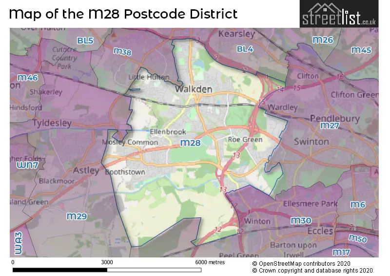
The M28 postal code covers the settlement of Worsley.
The M28 Postcode shares a border with M38 (Little Hulton), M27 (Swinton), M29 (Tyldesley), M30 (Eccles) and BL4 (Farnworth, Kearsley).
The primary settlement in the M28 postcode district is Worsley, located in Greater Manchester. Other significant settlements in this district include Manchester. The primary post town is Manchester in the county of Greater Manchester.
For the district M28, we have data on 6 postcode sectors. Here's a breakdown: The sector M28 0, covers Worsley in Greater Manchester. The sector M28 1, covers Worsley in Greater Manchester. The sector M28 2, covers Worsley in Greater Manchester. The sector M28 3, covers Worsley in Greater Manchester. The sector M28 7, covers Worsley in Greater Manchester. The sector M28 8 is non-geographic. It's often designated for PO Boxes, large organisations, or special services.


Map of the M28 Postcode District
Explore the M28 postcode district by using our free interactive map.
When it comes to local government, postal geography often disregards political borders. However, for a breakdown in the M28 District: the district mostly encompasses the Salford District (B) (1026 postcodes), and finally, the Wigan District (B) area (73 postcodes).
Recent House Sales in M28
| Date | Price | Address |
|---|---|---|
| 13/10/2023 | £198,000 | Fairhurst Drive, Worsley, Manchester, M28 0JJ |
| 12/10/2023 | £295,000 | Lambton Road, Worsley, Manchester, M28 2SU |
| 03/10/2023 | £136,000 | Bolton Road, Worsley, Manchester, M28 3BJ |
| 29/09/2023 | £230,000 | Roe Green Avenue, Worsley, Manchester, M28 2SA |
| 15/09/2023 | £400,000 | Highclove Lane, Worsley, Manchester, M28 1GZ |
| 13/09/2023 | £240,000 | Ribble Drive, Worsley, Manchester, M28 1JT |
| 08/09/2023 | £400,000 | Woodland Grange, Worsley, Manchester, M28 7AS |
| 05/09/2023 | £875,000 | Poynt Chase, Worsley, Manchester, M28 1FQ |
| 05/09/2023 | £85,660 | Worsley Gardens, Worsley, Manchester, M28 3ST |
| 30/08/2023 | £175,000 | Manchester Road, Worsley, Manchester, M28 3NS |
Weather Forecast for M28
Press Button to Show Forecast for Worsley
| Time Period | Icon | Description | Temperature | Rain Probability | Wind |
|---|---|---|---|---|---|
| 09:00 to 12:00 | Partly cloudy (day) | 7.0°C (feels like 6.0°C) | 2.00% | ENE 4 mph | |
| 12:00 to 15:00 | Cloudy | 9.0°C (feels like 8.0°C) | 9.00% | E 4 mph | |
| 15:00 to 18:00 | Cloudy | 10.0°C (feels like 9.0°C) | 6.00% | E 4 mph | |
| 18:00 to 21:00 | Cloudy | 9.0°C (feels like 9.0°C) | 6.00% | NE 4 mph | |
| 21:00 to 00:00 | Partly cloudy (night) | 6.0°C (feels like 4.0°C) | 4.00% | ENE 7 mph |
Press Button to Show Forecast for Worsley
| Time Period | Icon | Description | Temperature | Rain Probability | Wind |
|---|---|---|---|---|---|
| 00:00 to 03:00 | Partly cloudy (night) | 4.0°C (feels like 2.0°C) | 6.00% | ENE 4 mph | |
| 03:00 to 06:00 | Clear night | 3.0°C (feels like 1.0°C) | 4.00% | ENE 4 mph | |
| 06:00 to 09:00 | Partly cloudy (day) | 4.0°C (feels like 2.0°C) | 4.00% | ENE 7 mph | |
| 09:00 to 12:00 | Partly cloudy (day) | 8.0°C (feels like 6.0°C) | 5.00% | E 7 mph | |
| 12:00 to 15:00 | Overcast | 10.0°C (feels like 8.0°C) | 15.00% | E 7 mph | |
| 15:00 to 18:00 | Overcast | 10.0°C (feels like 8.0°C) | 19.00% | E 9 mph | |
| 18:00 to 21:00 | Cloudy | 10.0°C (feels like 8.0°C) | 14.00% | ENE 9 mph | |
| 21:00 to 00:00 | Cloudy | 7.0°C (feels like 5.0°C) | 15.00% | NE 9 mph |
Press Button to Show Forecast for Worsley
| Time Period | Icon | Description | Temperature | Rain Probability | Wind |
|---|---|---|---|---|---|
| 00:00 to 03:00 | Cloudy | 6.0°C (feels like 3.0°C) | 16.00% | NE 9 mph | |
| 03:00 to 06:00 | Cloudy | 6.0°C (feels like 3.0°C) | 18.00% | NNE 9 mph | |
| 06:00 to 09:00 | Light rain | 7.0°C (feels like 4.0°C) | 48.00% | NNE 9 mph | |
| 09:00 to 12:00 | Heavy rain | 8.0°C (feels like 5.0°C) | 70.00% | NNE 11 mph | |
| 12:00 to 15:00 | Heavy rain | 9.0°C (feels like 6.0°C) | 75.00% | N 11 mph | |
| 15:00 to 18:00 | Heavy rain | 10.0°C (feels like 7.0°C) | 76.00% | NNW 9 mph | |
| 18:00 to 21:00 | Light rain shower (day) | 10.0°C (feels like 8.0°C) | 36.00% | NNW 9 mph | |
| 21:00 to 00:00 | Partly cloudy (night) | 7.0°C (feels like 6.0°C) | 12.00% | NW 7 mph |
Where is the M28 Postcode District?
The data shows that the postcode district M28 is located in the town of Manchester. Manchester is surrounded by several nearby towns including Salford to the East, Leigh to the West, Bolton to the North, Sale to the South East, Bury to the North East, and Altrincham to the South. The distance between M28 and London is approximately 168.19 miles.
The district is within the post town of MANCHESTER.
The sector has postcodes within the nation of England.
The M28 Postcode District is covers the following regions.
- Greater Manchester South West - Greater Manchester - North West (England)
- Greater Manchester North West - Greater Manchester - North West (England)
| Postcode Sector | Delivery Office |
|---|---|
| M28 0 | North West (m) Delivery Office |
| M28 1 | North West (m) Delivery Office |
| M28 2 | North West (m) Delivery Office |
| M28 3 | North West (m) Delivery Office |
| M28 7 | North West (m) Delivery Office |
| M | 2 | 8 | - | X | X | X |
| M | 2 | 8 | Space | Numeric | Letter | Letter |
Current Monthly Rental Prices
| # Bedrooms | Min Price | Max Price | Avg Price |
|---|---|---|---|
| 1 | £750 | £750 | £750 |
| 2 | £795 | £1,400 | £944 |
| 3 | £995 | £2,000 | £1,366 |
| 4 | £1,300 | £3,195 | £1,991 |
| 5 | £1,950 | £5,000 | £3,475 |
Current House Prices
| # Bedrooms | Min Price | Max Price | Avg Price |
|---|---|---|---|
| 1 | £150,000 | £150,000 | £150,000 |
| 2 | £95,000 | £450,000 | £222,673 |
| 3 | £170,000 | £985,000 | £315,762 |
| 4 | £165,000 | £1,400,000 | £484,650 |
| 5 | £330,000 | £1,900,000 | £847,350 |
| 6 | £220,000 | £585,000 | £451,667 |
Estate Agents who Operate in the M28 District
| Logo | Name | Brand Name | Address | Contact Number | Total Properties |
|---|---|---|---|---|---|
 | Worsley | Sell Well | Office 6, Ellenbrook Village Centre, Worsley M28 1PB | 0161 524 2355 | 62 |
 | Worsley | Briscombe | 9 Barton Road Worsley Manchester M28 2PD | 0161 524 8117 | 34 |
 | Swinton | Miller Metcalfe | 2nd Floor, Lowry Mill Lees Street Pendlebury Swinton Salford M27 6DB | 0161 524 0938 | 26 |
 | Worsley | Millbrooke Estate Agents | 271 Mosley Common Road, Boothstown, Manchester M28 1BZ | 0161 524 9328 | 22 |
 | Worsley | Hunters | The Mill House, 6 Worsley Road, Worsley, Manchester, M28 2NL | 0161 524 3343 | 21 |
| Type of Property | 2018 Average | 2018 Sales | 2017 Average | 2017 Sales | 2016 Average | 2016 Sales | 2015 Average | 2015 Sales |
|---|---|---|---|---|---|---|---|---|
| Detached | £352,304 | 256 | £320,733 | 300 | £328,020 | 258 | £291,294 | 178 |
| Semi-Detached | £208,665 | 331 | £216,235 | 374 | £189,522 | 367 | £182,028 | 279 |
| Terraced | £162,912 | 273 | £158,593 | 267 | £151,482 | 272 | £132,403 | 220 |
| Flats | £113,147 | 42 | £120,228 | 71 | £93,941 | 74 | £100,013 | 60 |