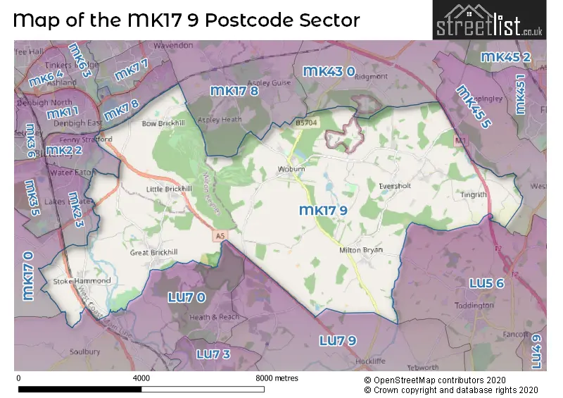
The MK17 9 postcode sector stands on the Bedfordshire and Buckinghamshire border.
Did you know? According to the 2021 Census, the MK17 9 postcode sector is home to a bustling 4,946 residents!
Given that each sector allows for 400 unique postcode combinations. Letters C, I, K, M, O and V are not allowed in the last two letters of a postcode. With 196 postcodes already in use, this leaves 204 units available.
The largest settlement in the MK17 9 postal code is Woburn followed by Stoke Hammond, and Great Brickhill.
The MK17 9 Postcode shares a border with MK17 8 (Woburn Sands, Glebe Farm, Aspley Guise), MK43 0 (Cranfield, Marston Moretaine, Lidlington), MK45 5 (Westoning, Pulloxhill, Flitton), LU5 6 (Toddington, Houghton Regis, Harlington), LU7 0 (Wing, Stewkley, Cheddington), MK17 0 (Newton Longville, Great Horwood, Little Horwood), LU7 9 (Pitstone, LEIGHTON BUZZARD, Hockliffe), MK1 1 (Bletchley, MILTON KEYNES), MK2 2 (Bletchley), MK2 3 (Bletchley) and MK7 8 (Old Farm Park, Caldecotte, Browns Wood).
The sector is within the post town of MILTON KEYNES.
MK17 9 is a postcode sector within the MK17 postcode district which is within the MK Milton Keynes postcode area.
The Royal Mail delivery office for the MK17 9 postal sector is the Brinklow (mk) Postal Delivery Office and Woburn Scale Payment Delivery Office and Little Brickhill Scale Payment Delivery Office.
The area of the MK17 9 postcode sector is 26.42 square miles which is 68.43 square kilometres or 16,910.08 square acres.
The MK17 9 postcode sector is crossed by the A5 Major A road.
The MK17 9 postcode sector is crossed by the M1 motorway.
Waterways within the MK17 9 postcode sector include the Grand Union Canal, Ouzel River, Clipstone Brook.

Map of the MK17 9 Postcode Sector
Explore the MK17 9 postcode sector by using our free interactive map.
| M | K | 1 | 7 | - | 9 | X | X |
| M | K | 1 | 7 | Space | 9 | Letter | Letter |
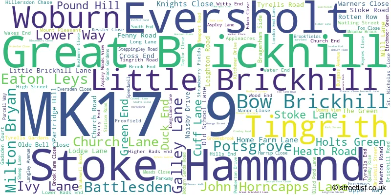
Official List of Streets
Stoke Hammond (25 Streets)
Woburn (27 Streets)
Bow Brickhill (17 Streets)
Eaton Leys (15 Streets)
Eversholt (12 Streets)
Little Brickhill (10 Streets)
Milton Bryan (3 Streets)
Great Brickhill (23 Streets)
Unofficial Streets or Alternative Spellings
Bletchley
STOKE ROAD WATLING STREET BATTLESDEN AVENUE BEDFORDSHIRE ROW - FP5 BEDFORDSHIRE ROW FP11 BELVEDERE LANE BRAGENHAM LANE EVERSHOLT ROAD BRIDGE GU104 HARLINGTON FOOTBRIDGE HOCKLIFFE ROAD HOME FARM TUNNEL KELLYS KITCHEN ROUNDABOUT LONDON ROAD LONGSLADE TRAIL (MTB RED ROUTE) MAGS LANE NEW WATER END OLD WATER END OLDE BELLE CLOSE PENNYCUIK PHEOBES ORCHARD POTTERS END RUSHMERE COURT SANDY LANE SHEEPLANE SHEEPS LANE STOKE HAMMOND AND LINSLADE WESTERN BYPASS TOWN MEAD BRIDGE TOWPATH V10 BRICKHILL ROAD V4 WATLING STREET WOBURN FIRE STATIONSteppingley
EVERSHOLT ROADToddington
PARK ROADStoke Hammond
DORCAS LANELEIGHTON BUZZARD
STOKE ROADTebworth
THE LANEHusborne Crawley
TURNPIKE ROADWoburn Sands
BOW BRICKHILL ROAD SANDY LANE WOBURN ROADHeath and Reach
WATLING STREETSchools and Places of Education Within the MK17 9 Postcode Sector
Bow Brickhill CofE VA Primary School
Voluntary aided school
Station Road, Milton Keynes, Buckinghamshire, MK17 9JT
Head: Mrs Pam McBurnie
Ofsted Rating: Good
Inspection: 2018-10-16 (2046 days ago)
Website: Visit Bow Brickhill CofE VA Primary School Website
Phone: 01908373672
Number of Pupils: 83
Eversholt Lower School
Academy converter
Church End, Milton Keynes, Bedfordshire, MK17 9DU
Head: Mrs Gaynor Miller
Ofsted Rating: Good
Inspection: 2023-11-15 (190 days ago)
Website: Visit Eversholt Lower School Website
Phone: 01525280298
Number of Pupils: 81
High Ash Church of England Primary School
Voluntary controlled school
Pound Hill, Milton Keynes, Buckinghamshire, MK17 9AS
Head: Mrs Ruth Lewin
Ofsted Rating: Requires improvement
Inspection: 2023-11-15 (190 days ago)
Website: Visit High Ash Church of England Primary School Website
Phone: 01525261620
Number of Pupils: 282
Woburn Lower School
Community school
Bedford Street, Woburn, Bedfordshire, MK17 9QL
Head: Mrs Paula Black
Ofsted Rating: Good
Inspection: 2023-12-06 (169 days ago)
Website: Visit Woburn Lower School Website
Phone: 01525290207
Number of Pupils: 57
House Prices in the MK17 9 Postcode Sector
| Type of Property | 2018 Average | 2018 Sales | 2017 Average | 2017 Sales | 2016 Average | 2016 Sales | 2015 Average | 2015 Sales |
|---|---|---|---|---|---|---|---|---|
| Detached | £707,931 | 29 | £590,428 | 64 | £555,463 | 43 | £665,712 | 30 |
| Semi-Detached | £430,423 | 13 | £337,708 | 12 | £338,500 | 15 | £331,423 | 13 |
| Terraced | £279,455 | 11 | £344,508 | 16 | £317,606 | 18 | £284,771 | 24 |
| Flats | £196,333 | 3 | £165,010 | 5 | £255,125 | 4 | £223,150 | 6 |
Important Postcodes MK17 9 in the Postcode Sector
MK17 9AS is the postcode for High Ash C of E Combined School, Pound Hill, Great Brickhill, and High Ash C of E Combined School, Pound Hill
MK17 9DU is the postcode for Eversholt Lower School, Church End
MK17 9JT is the postcode for Bow Brickhill C of E Primary School, Station Road
MK17 9LJ is the postcode for Woburn Golf Club, Little Brickhill
MK17 9PX is the postcode for The Woburn Hotel, George Street
MK17 9PY is the postcode for Buckinghamshire Fire & Rescue Service, Fire Station, George Street
MK17 9WA is the postcode for Woburn Abbey, Woburn
| The MK17 9 Sector is within these Local Authorities |
|
|---|---|
| The MK17 9 Sector is within these Counties |
|
| The MK17 9 Sector is within these Water Company Areas |
|
Tourist Attractions within the MK17 9 Postcode Area
We found 1 visitor attractions within the MK17 postcode area
| Go Ape! Tree Top Adventure - Woburn Safari Park |
|---|
| Country Parks |
| Country Park |
| View Go Ape! Tree Top Adventure - Woburn Safari Park on Google Maps |