The NE61 5 postcode sector is within the county of Northumberland.
Did you know? According to the 2021 Census, the NE61 5 postcode sector is home to a bustling 8,008 residents!
Given that each sector allows for 400 unique postcode combinations. Letters C, I, K, M, O and V are not allowed in the last two letters of a postcode. With 268 postcodes already in use, this leaves 132 units available.
The largest settlement in the NE61 5 postal code is Widdrington followed by Ellington, and Lynemouth.
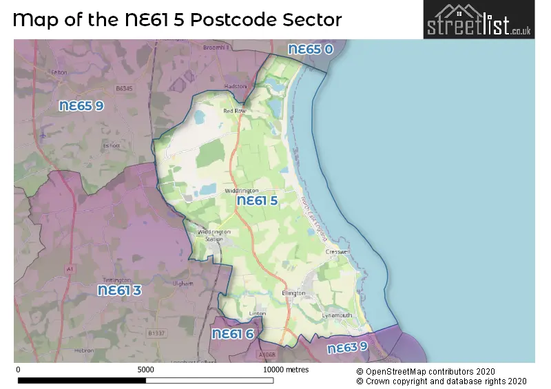
The NE61 5 Postcode shares a border with NE65 9 (Felton, Hadston, Swarland), NE61 6 (Pegswood, Stannington, St. Mary Park), NE63 8 (ASHINGTON, Jubilee Industrial Estate), NE63 9 (ASHINGTON, North Seaton, Meadow Vale), NE65 0 (Amble, Warkworth, High Hauxley) and NE61 3 (MORPETH, Longhirst, Ulgham).
The sector is within the post town of MORPETH.
NE61 5 is a postcode sector within the NE6 postcode district which is within the NE Newcastle upon Tyne postcode area.
The Royal Mail delivery office for the NE61 5 postal sector is the Heaton Delivery Office.
The area of the NE61 5 postcode sector is 19.61 square miles which is 50.79 square kilometres or 12,551.54 square acres.
Waterways within the NE61 5 postcode sector include the River Lyne, Linton Burn.

Map of the NE61 5 Postcode Sector
Explore the NE61 5 postcode sector by using our free interactive map.
| N | E | 6 | 1 | - | 5 | X | X |
| N | E | 6 | 1 | Space | 5 | Letter | Letter |
Official List of Streets
Stobswood (6 Streets)
Ellington (56 Streets)
Lynemouth (26 Streets)
Cresswell (7 Streets)
Widdrington (39 Streets)
Widdrington Village (5 Streets)
Linton Colliery (8 Streets)
Unofficial Streets or Alternative Spellings
Weather Forecast for NE61 5
Press Button to Show Forecast for Widdrington
| Time Period | Icon | Description | Temperature | Rain Probability | Wind |
|---|---|---|---|---|---|
| 00:00 to 03:00 | Clear night | 5.0°C (feels like 2.0°C) | 7.00% | SSW 9 mph | |
| 03:00 to 06:00 | Light rain shower (night) | 6.0°C (feels like 2.0°C) | 34.00% | S 9 mph | |
| 06:00 to 09:00 | Cloudy | 7.0°C (feels like 4.0°C) | 20.00% | SSW 9 mph | |
| 09:00 to 12:00 | Cloudy | 10.0°C (feels like 7.0°C) | 14.00% | S 16 mph | |
| 12:00 to 15:00 | Cloudy | 12.0°C (feels like 9.0°C) | 32.00% | S 16 mph | |
| 15:00 to 18:00 | Cloudy | 13.0°C (feels like 9.0°C) | 13.00% | S 16 mph | |
| 18:00 to 21:00 | Cloudy | 12.0°C (feels like 9.0°C) | 11.00% | S 18 mph | |
| 21:00 to 00:00 | Cloudy | 11.0°C (feels like 8.0°C) | 6.00% | S 16 mph |
Press Button to Show Forecast for Widdrington
| Time Period | Icon | Description | Temperature | Rain Probability | Wind |
|---|---|---|---|---|---|
| 00:00 to 03:00 | Cloudy | 10.0°C (feels like 7.0°C) | 4.00% | S 13 mph | |
| 03:00 to 06:00 | Partly cloudy (night) | 9.0°C (feels like 6.0°C) | 1.00% | SSE 11 mph | |
| 06:00 to 09:00 | Cloudy | 9.0°C (feels like 6.0°C) | 4.00% | SSE 13 mph | |
| 09:00 to 12:00 | Partly cloudy (day) | 11.0°C (feels like 8.0°C) | 1.00% | SE 16 mph | |
| 12:00 to 15:00 | Sunny day | 13.0°C (feels like 10.0°C) | 0.00% | SE 16 mph | |
| 15:00 to 18:00 | Partly cloudy (day) | 12.0°C (feels like 9.0°C) | 2.00% | SE 18 mph | |
| 18:00 to 21:00 | Cloudy | 11.0°C (feels like 8.0°C) | 5.00% | SE 16 mph | |
| 21:00 to 00:00 | Partly cloudy (night) | 9.0°C (feels like 7.0°C) | 5.00% | SE 11 mph |
Press Button to Show Forecast for Widdrington
| Time Period | Icon | Description | Temperature | Rain Probability | Wind |
|---|---|---|---|---|---|
| 00:00 to 03:00 | Partly cloudy (night) | 9.0°C (feels like 7.0°C) | 6.00% | SE 9 mph | |
| 03:00 to 06:00 | Cloudy | 8.0°C (feels like 7.0°C) | 10.00% | SE 4 mph | |
| 06:00 to 09:00 | Cloudy | 9.0°C (feels like 8.0°C) | 13.00% | SE 4 mph | |
| 09:00 to 12:00 | Cloudy | 11.0°C (feels like 9.0°C) | 12.00% | E 7 mph | |
| 12:00 to 15:00 | Partly cloudy (day) | 12.0°C (feels like 10.0°C) | 9.00% | E 7 mph | |
| 15:00 to 18:00 | Overcast | 11.0°C (feels like 9.0°C) | 11.00% | ENE 9 mph | |
| 18:00 to 21:00 | Overcast | 9.0°C (feels like 8.0°C) | 11.00% | NE 7 mph | |
| 21:00 to 00:00 | Cloudy | 9.0°C (feels like 7.0°C) | 11.00% | NNE 9 mph |
Press Button to Show Forecast for Widdrington
| Time Period | Icon | Description | Temperature | Rain Probability | Wind |
|---|---|---|---|---|---|
| 00:00 to 03:00 | Cloudy | 9.0°C (feels like 6.0°C) | 9.00% | N 11 mph | |
| 03:00 to 06:00 | Overcast | 9.0°C (feels like 6.0°C) | 11.00% | N 11 mph | |
| 06:00 to 09:00 | Cloudy | 9.0°C (feels like 6.0°C) | 8.00% | N 13 mph | |
| 09:00 to 12:00 | Cloudy | 10.0°C (feels like 8.0°C) | 7.00% | N 13 mph | |
| 12:00 to 15:00 | Partly cloudy (day) | 12.0°C (feels like 9.0°C) | 3.00% | NNE 13 mph | |
| 15:00 to 18:00 | Partly cloudy (day) | 11.0°C (feels like 9.0°C) | 1.00% | NNE 13 mph | |
| 18:00 to 21:00 | Cloudy | 10.0°C (feels like 8.0°C) | 4.00% | NNE 13 mph | |
| 21:00 to 00:00 | Partly cloudy (night) | 9.0°C (feels like 6.0°C) | 2.00% | N 11 mph |
Schools and Places of Education Within the NE61 5 Postcode Sector
Ellington Primary School
Community school
Warkworth Drive, Morpeth, Northumberland, NE61 5HL
Head: Mr Kevin Hodgson
Ofsted Rating: Good
Inspection: 2019-01-09 (1937 days ago)
Website: Visit Ellington Primary School Website
Phone: 01670860769
Number of Pupils: 215
Grange View Church of England Voluntary Controlled First School
Voluntary controlled school
Grange Road, Morpeth, Northumberland, NE61 5LZ
Head: Mrs Louise Laskey
Ofsted Rating: Good
Inspection: 2019-02-27 (1888 days ago)
Website: Visit Grange View Church of England Voluntary Controlled First School Website
Phone: 01670790686
Number of Pupils: 107
Linton Primary School
Community school
Linton, Morpeth, Northumberland, NE61 5SG
Head: Mrs Samantha Mason
Ofsted Rating: Good
Inspection: 2019-06-26 (1769 days ago)
Website: Visit Linton Primary School Website
Phone: 01670860361
Number of Pupils: 21
Red Row First School
Community school
Red Row, Morpeth, Northumberland, NE61 5AS
Head: Mr Richard Bollands
Ofsted Rating: Good
Inspection: 2023-01-20 (465 days ago)
Website: Visit Red Row First School Website
Phone: 01670760282
Number of Pupils: 94
House Prices in the NE61 5 Postcode Sector
| Type of Property | 2018 Average | 2018 Sales | 2017 Average | 2017 Sales | 2016 Average | 2016 Sales | 2015 Average | 2015 Sales |
|---|---|---|---|---|---|---|---|---|
| Detached | £220,456 | 51 | £227,352 | 45 | £223,837 | 31 | £217,405 | 38 |
| Semi-Detached | £119,234 | 53 | £124,097 | 45 | £120,122 | 36 | £121,050 | 34 |
| Terraced | £74,275 | 61 | £103,554 | 55 | £88,511 | 51 | £66,797 | 56 |
| Flats | £53,333 | 3 | £45,000 | 1 | £67,113 | 4 | £50,475 | 4 |
Important Postcodes NE61 5 in the Postcode Sector
NE61 5AS is the postcode for Red Row First School, Red Row
NE61 5HL is the postcode for MAIN BUILDING, Ellington County First School, Warkworth Drive, and Ellington Primary School, Warkworth Drive
NE61 5LX is the postcode for The Widdrington Surgery, Grange Road
NE61 5LZ is the postcode for Widdrington Grange View County First School, Grange Road, and Grange View C Of E Vol Controlled First School, Grange Road
NE61 5SG is the postcode for Linton County First School, Linton Colliery
NE61 5TB is the postcode for Lynemouth Medical Centre, Albion Terrace
NE61 5TR is the postcode for William Leech C of E Academy, Church Square, Lynemouth, William Leech Campus, Church Square, Ncea William Leech C Of E Primary, Church Square, and Lynemouth First School, Church Square
| The NE61 5 Sector is within these Local Authorities |
|
|---|---|
| The NE61 5 Sector is within these Counties |
|
| The NE61 5 Sector is within these Water Company Areas |
|