The NE61 6 postcode sector is within the county of Northumberland.
Did you know? According to the 2021 Census, the NE61 6 postcode sector is home to a bustling 6,365 residents!
Given that each sector allows for 400 unique postcode combinations. Letters C, I, K, M, O and V are not allowed in the last two letters of a postcode. With 270 postcodes already in use, this leaves 130 units available.
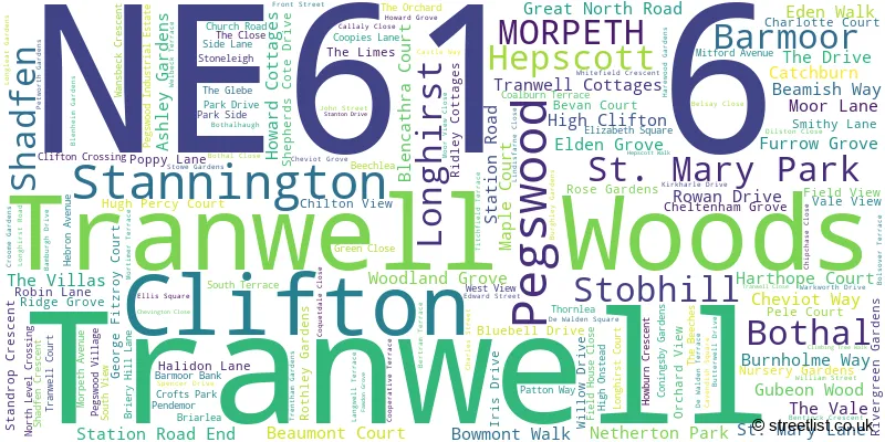
The largest settlement in the NE61 6 postal code is Pegswood followed by Stannington, and St. Mary Park.
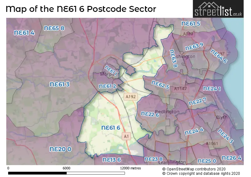
The NE61 6 Postcode shares a border with NE22 6 (BEDLINGTON, Fenwick Park, Nedderton Village), NE23 1 (CRAMLINGTON, St. Nicholas Manor, Nelson Village), NE61 1 (MORPETH), NE61 5 (Widdrington, Ellington, Lynemouth), NE62 5 (CHOPPINGTON, Scotland Gate, West Sleekburn), NE63 8 (ASHINGTON, Jubilee Industrial Estate), NE13 6 (Wideopen, Seaton Burn, North Gosforth), NE20 0 (Ponteland, Belsay, Matfen), NE23 3 (CRAMLINGTON, Hartford, Shankhouse), NE23 8 (CRAMLINGTON, The Fairways, West Meadows), NE61 2 (MORPETH, Loansdean, Collingwood Manor) and NE61 3 (MORPETH, Longhirst, Ulgham).
The sector is within the post town of MORPETH.
NE61 6 is a postcode sector within the NE61 postcode district which is within the NE Newcastle upon Tyne postcode area.
The Royal Mail delivery office for the NE61 6 postal sector is the Morpeth Delivery Office.
The area of the NE61 6 postcode sector is 21.26 square miles which is 55.07 square kilometres or 13,607.47 square acres.
The NE61 6 postcode sector is crossed by the A1 Major A road.
Waterways within the NE61 6 postcode sector include the Wansbeck, Blyth.

Map of the NE61 6 Postcode Sector
Explore the NE61 6 postcode sector by using our free interactive map.
| N | E | 6 | 1 | - | 6 | X | X |
| N | E | 6 | 1 | Space | 6 | Letter | Letter |
Official List of Streets
Pegswood (70 Streets)
St. Mary Park (19 Streets)
Barmoor (1 Streets)
Stannington (32 Streets)
MORPETH (8 Streets)
Hepscott (11 Streets)
Clifton (2 Streets)
Tranwell Woods (1 Streets)
Tranwell (1 Streets)
Unofficial Streets or Alternative Spellings
MORPETH
BROOM CLOSE CHOPPINGTON ROAD RENNINGTON CLOSE SHIELDS ROAD TURNER SQUARESeaton Burn
GREEN LANEWeather Forecast for NE61 6
Press Button to Show Forecast for Carlisle Park (Morpeth)
| Time Period | Icon | Description | Temperature | Rain Probability | Wind |
|---|---|---|---|---|---|
| 09:00 to 12:00 | Cloudy | 6.0°C (feels like 4.0°C) | 8.00% | NNE 7 mph | |
| 12:00 to 15:00 | Cloudy | 7.0°C (feels like 5.0°C) | 28.00% | ENE 7 mph | |
| 15:00 to 18:00 | Cloudy | 7.0°C (feels like 6.0°C) | 10.00% | E 7 mph | |
| 18:00 to 21:00 | Sunny day | 7.0°C (feels like 5.0°C) | 4.00% | E 7 mph | |
| 21:00 to 00:00 | Clear night | 3.0°C (feels like 1.0°C) | 2.00% | SE 4 mph |
Press Button to Show Forecast for Carlisle Park (Morpeth)
| Time Period | Icon | Description | Temperature | Rain Probability | Wind |
|---|---|---|---|---|---|
| 00:00 to 03:00 | Partly cloudy (night) | 2.0°C (feels like 0.0°C) | 2.00% | SE 4 mph | |
| 03:00 to 06:00 | Clear night | 1.0°C (feels like -1.0°C) | 3.00% | SSW 4 mph | |
| 06:00 to 09:00 | Partly cloudy (day) | 3.0°C (feels like 1.0°C) | 5.00% | SSE 4 mph | |
| 09:00 to 12:00 | Cloudy | 8.0°C (feels like 6.0°C) | 9.00% | ESE 7 mph | |
| 12:00 to 15:00 | Partly cloudy (day) | 9.0°C (feels like 6.0°C) | 8.00% | ESE 9 mph | |
| 15:00 to 18:00 | Sunny day | 9.0°C (feels like 6.0°C) | 6.00% | E 11 mph | |
| 18:00 to 21:00 | Partly cloudy (day) | 8.0°C (feels like 5.0°C) | 6.00% | E 11 mph | |
| 21:00 to 00:00 | Cloudy | 6.0°C (feels like 3.0°C) | 11.00% | E 7 mph |
Press Button to Show Forecast for Carlisle Park (Morpeth)
| Time Period | Icon | Description | Temperature | Rain Probability | Wind |
|---|---|---|---|---|---|
| 00:00 to 03:00 | Cloudy | 5.0°C (feels like 2.0°C) | 14.00% | NE 7 mph | |
| 03:00 to 06:00 | Cloudy | 6.0°C (feels like 3.0°C) | 14.00% | NE 9 mph | |
| 06:00 to 09:00 | Overcast | 7.0°C (feels like 3.0°C) | 17.00% | NE 11 mph | |
| 09:00 to 12:00 | Light rain | 7.0°C (feels like 4.0°C) | 49.00% | NE 13 mph | |
| 12:00 to 15:00 | Light rain | 8.0°C (feels like 4.0°C) | 50.00% | NNE 13 mph | |
| 15:00 to 18:00 | Cloudy | 8.0°C (feels like 5.0°C) | 19.00% | NNE 13 mph | |
| 18:00 to 21:00 | Partly cloudy (day) | 8.0°C (feels like 7.0°C) | 13.00% | NNE 9 mph | |
| 21:00 to 00:00 | Partly cloudy (night) | 6.0°C (feels like 3.0°C) | 10.00% | SE 9 mph |
Schools and Places of Education Within the NE61 6 Postcode Sector
Pegswood Primary School
Community school
Longhirst Road, Morpeth, Northumberland, NE61 6XG
Head: Mr Andrew Waterfield
Ofsted Rating: Good
Inspection: 2022-06-22 (674 days ago)
Website: Visit Pegswood Primary School Website
Phone: 01670512834
Number of Pupils: 158
Rosewood Independent School
Other independent special school
Ardlea, Station Road End, Morpeth, Northumberland, NE61 6DR
Head: Mrs Janice Woods
Ofsted Rating: Good
Inspection: 2023-10-19 (190 days ago)
Website: Visit Rosewood Independent School Website
Phone: 07899827630
Number of Pupils: 20
Stannington First School
Community school
Church Road, Morpeth, Northumberland, NE61 6HJ
Head: Mrs Alexandra Palmer
Ofsted Rating: Good
Inspection: 2022-11-23 (520 days ago)
Website: Visit Stannington First School Website
Phone: 01670789276
Number of Pupils: 123
House Prices in the NE61 6 Postcode Sector
| Type of Property | 2018 Average | 2018 Sales | 2017 Average | 2017 Sales | 2016 Average | 2016 Sales | 2015 Average | 2015 Sales |
|---|---|---|---|---|---|---|---|---|
| Detached | £338,068 | 82 | £346,299 | 76 | £396,400 | 56 | £369,599 | 49 |
| Semi-Detached | £148,437 | 44 | £145,474 | 47 | £134,907 | 30 | £175,459 | 29 |
| Terraced | £152,276 | 39 | £112,744 | 24 | £169,939 | 18 | £155,014 | 13 |
| Flats | £122,662 | 24 | £117,415 | 6 | £136,390 | 5 | £49,167 | 3 |
Important Postcodes NE61 6 in the Postcode Sector
NE61 6DE is the postcode for Northumberland County Council, Kyloe House Secure Unit, Kyloe House Secure Unit, Netherton Park, Stannington, BLOCK 7, Northumberland County Council, Netherton Park Childrens Home,, Northumberland County Council, Netherton Park Childrens Home,, BLOCK 1, Northumberland County Council, Netherton Park Childrens Home,, and Assessment Centre, Netherton Park
NE61 6HJ is the postcode for Stannington First School, Stannington
NE61 6JT is the postcode for Northumberland County Council, Coopies Lane Depot, Coopies Lane, and Northumberland County Council Depot, Coopies Way
NE61 6NF is the postcode for TWEED HOUSE, Northumberland County Council, Hepscott Park,, Northumberland County Council, Hepscott Park,, and ADMIN BLOCK, Northumberland County Council, Hepscott Park,
NE61 6SH is the postcode for Pegswood Fire Station, Bothal Road, Pegswood, and Pegswood Fire Station, Bothal Road
NE61 6XG is the postcode for Pegswood County First School, Longhirst Road, Pegswood, KEY STAGE 2 BUILDING, Pegswood County First School, Longhirst Road, and MAIN BUILDING, Pegswood County First School, Longhirst Road
| The NE61 6 Sector is within these Local Authorities |
|
|---|---|
| The NE61 6 Sector is within these Counties |
|
| The NE61 6 Sector is within these Water Company Areas |
|