The NG19 postcode district is a postal district located in the NG Nottingham postcode area with a population of 54,389 residents according to the 2021 England and Wales Census.
The area of the NG19 postcode district is 15.54 square miles which is 40.24 square kilometres or 9,944.56 acres.
Currently, the NG19 district has about 1206 postcode units spread across 5 geographic postcode sectors.
Given that each sector allows for 400 unique postcode combinations, the district has a capacity of 2,000 postcodes. With 1206 postcodes already in use, this leaves 794 units available.
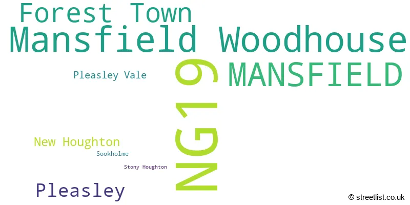
The largest settlement in the NG19 postal code is Mansfield Woodhouse followed by MANSFIELD, and Forest Town.
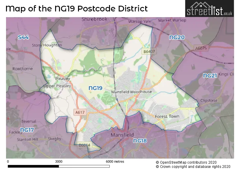
The NG19 Postcode shares a border with NG17 (SUTTON-IN-ASHFIELD, Kirkby-in-Ashfield, Huthwaite), S44 (Bolsover, Calow, Duckmanton), NG20 (Shirebrook, Warsop, Langwith), NG21 (Rainworth, Edwinstowe, Clipstone Village) and NG18 (MANSFIELD).
The primary settlement in the NG19 postcode district is Forest Town, located in Mansfield, Nottinghamshire. Other significant settlements in the district include Mansfield Woodhouse, Pleasley, New Houghton, Pleasley Vale, Sookholme, and Stony Houghton. The postcode district is primarily associated with the post town of Mansfield in Nottinghamshire, England.
For the district NG19, we have data on 5 postcode sectors. Here's a breakdown: The sector NG19 0, covers Forest Town in Nottinghamshire. The sector NG19 6, covers Mansfield in Nottinghamshire. The sector NG19 7, covers Mansfield and Pleasley in Nottinghamshire. The sector NG19 7, covers Pleasley in Derbyshire. The sector NG19 8, covers Mansfield Woodhouse in Nottinghamshire. The sector NG19 8, covers New Houghton in Derbyshire. The sector NG19 9, covers Mansfield Woodhouse in Nottinghamshire.

Map of the NG19 Postcode District
Explore the NG19 postcode district by using our free interactive map.
When it comes to local government, postal geography often disregards political borders. However, for a breakdown in the NG19 District: the district mostly encompasses the Mansfield District (1132 postcodes), and finally, the Bolsover District area (82 postcodes).
Recent House Sales in NG19
| Date | Price | Address |
|---|---|---|
| 13/10/2023 | £179,995 | West Bank Lea, Mansfield, NG19 7BY |
| 09/10/2023 | £150,000 | Grizedale Close, Forest Town, Mansfield, NG19 0GY |
| 06/10/2023 | £110,000 | Fairholme Drive, Mansfield, NG19 6DJ |
| 06/10/2023 | £120,000 | Skegby Lane, Mansfield, NG19 6PF |
| 06/10/2023 | £103,000 | Yorke Street, Mansfield Woodhouse, Mansfield, NG19 9NG |
| 29/09/2023 | £192,000 | Garwick Close, Forest Town, Mansfield, NG19 0LU |
| 28/09/2023 | £210,000 | Robey Close, Forest Town, Mansfield, NG19 0DY |
| 26/09/2023 | £173,000 | Edgehill Grove, Mansfield Woodhouse, Mansfield, NG19 9AS |
| 15/09/2023 | £268,000 | Beech Hill Crescent, Mansfield, NG19 7EW |
| 15/09/2023 | £153,000 | Walton Close, Forest Town, Mansfield, NG19 0DA |
Weather Forecast for NG19
Press Button to Show Forecast for Mansfield Woodhouse
| Time Period | Icon | Description | Temperature | Rain Probability | Wind |
|---|---|---|---|---|---|
| 21:00 to 00:00 | Cloudy | 6.0°C (feels like 4.0°C) | 5.00% | ENE 4 mph |
Press Button to Show Forecast for Mansfield Woodhouse
| Time Period | Icon | Description | Temperature | Rain Probability | Wind |
|---|---|---|---|---|---|
| 00:00 to 03:00 | Cloudy | 5.0°C (feels like 3.0°C) | 4.00% | NE 4 mph | |
| 03:00 to 06:00 | Partly cloudy (night) | 4.0°C (feels like 2.0°C) | 2.00% | NNE 4 mph | |
| 06:00 to 09:00 | Cloudy | 4.0°C (feels like 1.0°C) | 5.00% | NNE 4 mph | |
| 09:00 to 12:00 | Cloudy | 8.0°C (feels like 5.0°C) | 13.00% | NE 9 mph | |
| 12:00 to 15:00 | Overcast | 9.0°C (feels like 7.0°C) | 22.00% | ENE 9 mph | |
| 15:00 to 18:00 | Overcast | 9.0°C (feels like 6.0°C) | 16.00% | ENE 11 mph | |
| 18:00 to 21:00 | Overcast | 8.0°C (feels like 5.0°C) | 13.00% | NE 11 mph | |
| 21:00 to 00:00 | Overcast | 7.0°C (feels like 4.0°C) | 11.00% | NE 9 mph |
Press Button to Show Forecast for Mansfield Woodhouse
| Time Period | Icon | Description | Temperature | Rain Probability | Wind |
|---|---|---|---|---|---|
| 00:00 to 03:00 | Overcast | 6.0°C (feels like 3.0°C) | 10.00% | NNE 11 mph | |
| 03:00 to 06:00 | Light rain | 6.0°C (feels like 2.0°C) | 77.00% | N 11 mph | |
| 06:00 to 09:00 | Heavy rain | 5.0°C (feels like 2.0°C) | 81.00% | N 13 mph | |
| 09:00 to 12:00 | Heavy rain | 6.0°C (feels like 3.0°C) | 82.00% | NNW 13 mph | |
| 12:00 to 15:00 | Light rain | 7.0°C (feels like 4.0°C) | 50.00% | NW 11 mph | |
| 15:00 to 18:00 | Cloudy | 10.0°C (feels like 7.0°C) | 13.00% | WNW 9 mph | |
| 18:00 to 21:00 | Sunny day | 10.0°C (feels like 8.0°C) | 5.00% | W 9 mph | |
| 21:00 to 00:00 | Clear night | 7.0°C (feels like 5.0°C) | 3.00% | SW 7 mph |
Press Button to Show Forecast for Mansfield Woodhouse
| Time Period | Icon | Description | Temperature | Rain Probability | Wind |
|---|---|---|---|---|---|
| 00:00 to 03:00 | Clear night | 5.0°C (feels like 3.0°C) | 1.00% | SW 7 mph | |
| 03:00 to 06:00 | Clear night | 4.0°C (feels like 2.0°C) | 0.00% | SSW 7 mph | |
| 06:00 to 09:00 | Sunny day | 5.0°C (feels like 3.0°C) | 1.00% | SSW 7 mph | |
| 09:00 to 12:00 | Sunny day | 10.0°C (feels like 8.0°C) | 1.00% | S 11 mph | |
| 12:00 to 15:00 | Cloudy | 13.0°C (feels like 10.0°C) | 5.00% | S 13 mph | |
| 15:00 to 18:00 | Overcast | 14.0°C (feels like 11.0°C) | 19.00% | S 13 mph | |
| 18:00 to 21:00 | Partly cloudy (day) | 13.0°C (feels like 11.0°C) | 3.00% | S 11 mph | |
| 21:00 to 00:00 | Clear night | 10.0°C (feels like 8.0°C) | 2.00% | SSE 9 mph |
Press Button to Show Forecast for Mansfield Woodhouse
| Time Period | Icon | Description | Temperature | Rain Probability | Wind |
|---|---|---|---|---|---|
| 00:00 to 03:00 | Clear night | 8.0°C (feels like 6.0°C) | 2.00% | SSE 9 mph | |
| 03:00 to 06:00 | Clear night | 7.0°C (feels like 5.0°C) | 2.00% | SE 7 mph | |
| 06:00 to 09:00 | Mist | 7.0°C (feels like 5.0°C) | 16.00% | ESE 7 mph | |
| 09:00 to 12:00 | Cloudy | 12.0°C (feels like 10.0°C) | 8.00% | ESE 9 mph | |
| 12:00 to 15:00 | Partly cloudy (day) | 15.0°C (feels like 13.0°C) | 5.00% | ESE 11 mph | |
| 15:00 to 18:00 | Cloudy | 16.0°C (feels like 13.0°C) | 10.00% | ESE 11 mph | |
| 18:00 to 21:00 | Partly cloudy (day) | 14.0°C (feels like 13.0°C) | 7.00% | ESE 9 mph | |
| 21:00 to 00:00 | Cloudy | 12.0°C (feels like 10.0°C) | 9.00% | E 7 mph |
Where is the NG19 Postcode District?
The postcode district NG19 is located in Mansfield, a town in Nottinghamshire. It is situated nearby Sutton-in-Ashfield to the South West, Chesterfield to the North West, Worksop to the North East, Southwell to the South East, and Nottingham to the South. The distance from NG19 to London is approximately 123.65 miles.
The district is within the post town of MANSFIELD.
The sector has postcodes within the nation of England.
The NG19 Postcode District is covers the following regions.
- North Nottinghamshire - Derbyshire and Nottinghamshire - East Midlands (England)
- East Derbyshire - Derbyshire and Nottinghamshire - East Midlands (England)
| Postcode Sector | Delivery Office |
|---|---|
| NG19 1 | Mansfield Delivery Office |
| NG19 2 | Mansfield Delivery Office |
| NG19 3 | Mansfield Delivery Office |
| NG19 4 | Mansfield Delivery Office |
| NG19 5 | Mansfield Delivery Office |
| NG19 6 | Mansfield Delivery Office |
| NG19 7 | Mansfield Delivery Office |
| NG19 8 | Mansfield Delivery Office |
| NG19 9 | Mansfield Delivery Office |
| N | G | 1 | 9 | - | X | X | X |
| N | G | 1 | 9 | Space | Numeric | Letter | Letter |
Current Monthly Rental Prices
| # Bedrooms | Min Price | Max Price | Avg Price |
|---|---|---|---|
| £150 | £150 | £150 | |
| 1 | £464 | £750 | £552 |
| 2 | £635 | £750 | £709 |
| 3 | £695 | £1,200 | £928 |
| 4 | £1,195 | £1,370 | £1,279 |
Current House Prices
| # Bedrooms | Min Price | Max Price | Avg Price |
|---|---|---|---|
| £5,000 | £850,000 | £323,333 | |
| 2 | £90,000 | £650,000 | £167,588 |
| 3 | £74,000 | £425,000 | £211,698 |
| 4 | £125,000 | £690,000 | £327,532 |
| 5 | £490,000 | £750,000 | £638,000 |
| 6 | £430,000 | £850,000 | £710,000 |
| 7 | £800,000 | £800,000 | £800,000 |
Estate Agents who Operate in the NG19 District
| Logo | Name | Brand Name | Address | Contact Number | Total Properties |
|---|---|---|---|---|---|
 | Mansfield | BuckleyBrown | 55-57 Leeming Street, Mansfield, Notts, NG18 1ND | 01623 705218 | 81 |
 | Mansfield | John Sankey | 41 Albert Street, Mansfield, NG18 1EA | 01623 705319 | 25 |
 | covering Nottingham | Purplebricks | Suite 7 First Floor Cranmore Drive Shirley Solihull B90 4RZ | 020 3908 1066 | 18 |
 | Mansfield Woodhouse | Bairstow Eves | 5 High Street, Mansfield Woodhouse, Mansfield, Nottinghamshire, NG19 8BB | 01623 701199 | 17 |
 | Nottingham | Pygott & Crone | 43 Bridlesmith Gate Nottingham NG1 2GN | 0115 647 9352 | 14 |
| Type of Property | 2018 Average | 2018 Sales | 2017 Average | 2017 Sales | 2016 Average | 2016 Sales | 2015 Average | 2015 Sales |
|---|---|---|---|---|---|---|---|---|
| Detached | £202,994 | 349 | £184,980 | 302 | £178,262 | 349 | £180,657 | 358 |
| Semi-Detached | £122,767 | 415 | £120,560 | 415 | £109,790 | 427 | £106,577 | 393 |
| Terraced | £91,664 | 213 | £88,186 | 193 | £85,314 | 188 | £82,196 | 186 |
| Flats | £76,457 | 23 | £69,214 | 27 | £83,221 | 19 | £74,355 | 21 |